Ordinary Meeting of Council
Minutes
Monday 27 June 2016
At 7 pm
Council Chamber
Functions Centre
45 Princes Highway
Werribee
Ordinary Meeting of Council
Minutes
Monday 27 June 2016
At 7 pm
Council Chamber
Functions Centre
45 Princes Highway
Werribee
|
|
MINUTES
Ordinary Meeting of Council HELD AT THE COUNCIL CHAMBERS, CIVIC CENTRE, 45 PRINCES HIGHWAY, WERRIBEE ON Monday 27 June 2016 |
The meeting commenced at 7.01 pm.
PRESENT: Cr Adele Hegedich (Chairperson)
Cr Peter Maynard
Cr Bob Fairclough
Cr Heather Marcus
Cr Marie Brittan
Cr Glenn Goodfellow
Cr Gautam Gupta
Cr John Gibbons
Cr Intaj Khan
Cr Michele Wharrie
IN ATTENDANCE: Kelly Grigsby Chief Executive Officer
Binda Gokhale A/Director Corporate Services
David Suder Director Infrastructure
Bill Forrest Director Advocacy
Dean Rochfort Director Sustainable Development
Jenny McMahon A/Director Community Development
Emily Keogh Manager Communications & Events
Xavier Smerdon Communications Officer
Nicole Battle A/Co-ordinator Governance & City Engagement
Sandra Noonan Governance Officer
1. OPENING PRAYER & WELCOME
The Mayor, Cr Hegedich, welcomed all in attendance to the meeting.
2. APOLOGIES & REQUESTS FOR LEAVE
|
CRS Peter Maynard / Bob Fairclough
That apologies be accepted from Cr Peter Gibbons.
(CARRIED) |
3. DECLARATION BY COUNCILLORS OF DISCLOSURE OF CONFLICT OF INTEREST/CONFLICTING PERSONAL INTEREST IN ANY ITEM OF THE AGENDA
Cr Heather Marcus declared a conflict of interest in the following item:
6.5.2 Adoption of Integrated Plan and Budget 2016/17 (Point 1 and 2) – direct conflict of interest due to financial interest in commercial property in the vicinity of the item being considered.
Cr Intaj Khan declared a conflict of interest in the following item:
6.5.2 Proposed Integrated Plan and Budget 2016/17 (Point 3) – direct conflict of interest due to ownership of residential property in the vicinity of the item being considered.
4. CONFIRMATION OF MINUTES OF PREVIOUS MEETING
|
CRS Peter Maynard / John Gibbons That the following minutes, as prepared and circulated, be confirmed: 1. Ordinary Council Meeting held on Monday, 23 May 2016;
2. Special Council Meeting held 5.30pm on Tuesday, 14 June 2016; - Review of Councillors Code of Conduct.
3. Special Council Meeting held 7.00pm on Tuesday 14 June 2016; - Hearing of Submissions on the Integrated Plan and Budget 2016/17. - Two items of a confidential nature relating to contractual matters.
(CARRIED) |
5. Deputations and Presentations
Queen’s Birthday Honours List 2016 - Australian Police Medal
The Mayor congratulated Superintendent Stuart Bateson, on receiving the Australian Police Medal as part of the Queen’s Birthday Honours Awards. Stuart’s contribution to the Victoria Police has been significant across so many areas of work and it is terrific that he has received public recognition for so many years of dedicated service in such complex and challenging roles.
From Council’s perspective, we have been fortunate to have Stuart’s involvement and willingness to partner with us through structures such as the Wyndham Community Safety Roundtable and on a range of issues that impact on the wellbeing and safety of our local community. The Mayor also acknowledged his personal commitment and willingness to support and mentor young people.
Council will send letters of congratulations and appreciation to Superintendent Stuart Bateson.
Wyndham Leaders of the Future 2016 Program
Councillor Marie Brittan together with Councillor Bob Fairclough had great pleasure in attending a ceremony for the Wyndham Leaders of the Future Kokoda Expedition. This is a group of young people who went through physical training for quite some time, to undertake a trek on the Kokoda Trail.
Councillor Brittan mentioned that it was interesting that Stuart Bateson had been acknowledged previously as he went on the trek as Local Area Commander, Westgate Divisional Command, together with James Ridsdale of our local police who was one of the leaders of the group.
An integral part of this program involved community engagement with a structured partnership forged with Rotary branches within Wyndham. This enabled young leaders to build upon their skills and user knowledge by participating in scheduled Rotary community events. It also provides them with exposure to prominent local businesses. Another structured community engagement event is assisting in supervision of the Blue Light Discos.
Powerful words such as endurance, courage, mateship and sacrifice had described how Australian soldiers made it through their World War II campaign in Papua New Guinea and also epitomised the enduring qualities of the young leaders who trekked the Kokoda Trail as they realised the mental strength within them to overcome many obstacles on the Kokoda Trail and indeed in life. This experience will be a major focus of the project to ultimately build an individual’s resilience.
The young people acknowledged this, they were physically fit and all completed the trek but found that they really had some challenges on the journey. There were emotional challenges, one of which was making it to the end of the trek, standing at the memorial at the top and having a ceremony. They were extremely touched by the number of graves on the trek and the number of unnamed graves and felt it was very sad that Australian soldiers lay up there in graves with no names on them.
The experience stands them in very good stead as future leaders in our community.
Councillors Brittan and Fairclough were presented with a photo in recognition of the support that Wyndham City Council continues to give this group of people which Councillor Brittan presented to the Mayor.
6. OFFICERS’ REPORTS (incorporating questions with notice)
6.1 Petitions
NIL
6.2 Strategic Reports
6.2.1 Wyndham Integrated Transport Policy and Wyndham Integrated Transport Strategy 7
6.3 Policy/Advocacy
6.3.1 Procurement Policy Review June 2016 13
6.3.2 Residential Growth Management Strategy Review and Update 15
6.3.3 Submission to Infrastructure Victoria "All things Considered" 25
6.4 Strategic & Town Planning
6.4.1 Wyndham North Development Contributions Plan - Project Implementation Programme 37
6.4.2 Planning Scheme Amendment C197 - Boundary Road Design Guidelines 45
6.4.3 Planning Permit Application WYP8078/14 - Amendment for VCAT - 500 Purchas Street - Residential Subdivision 53
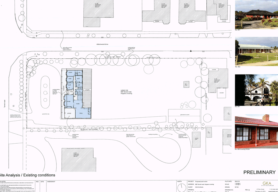
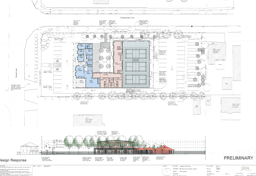
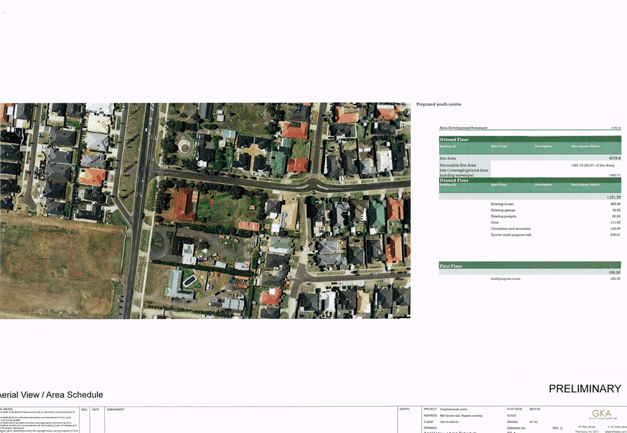
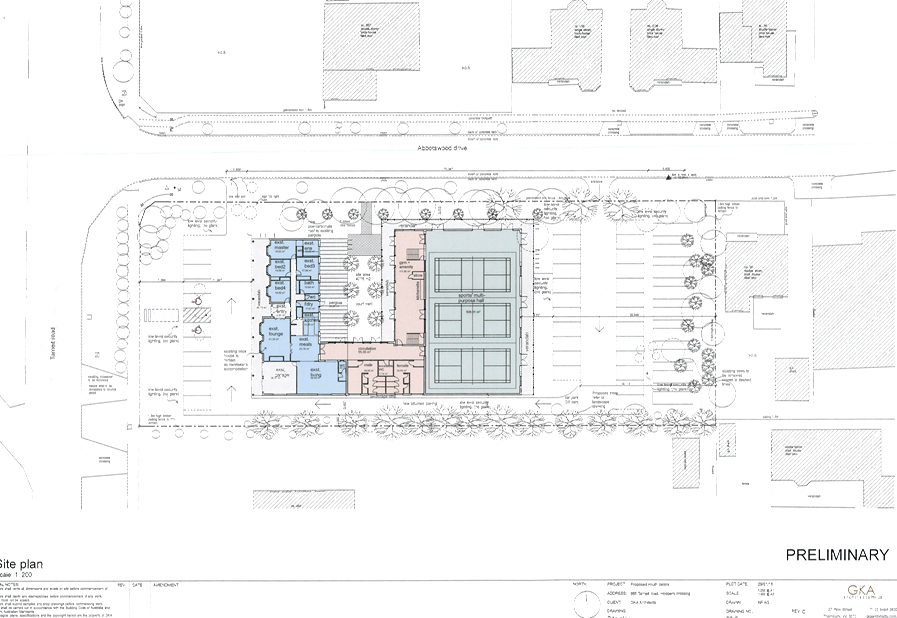
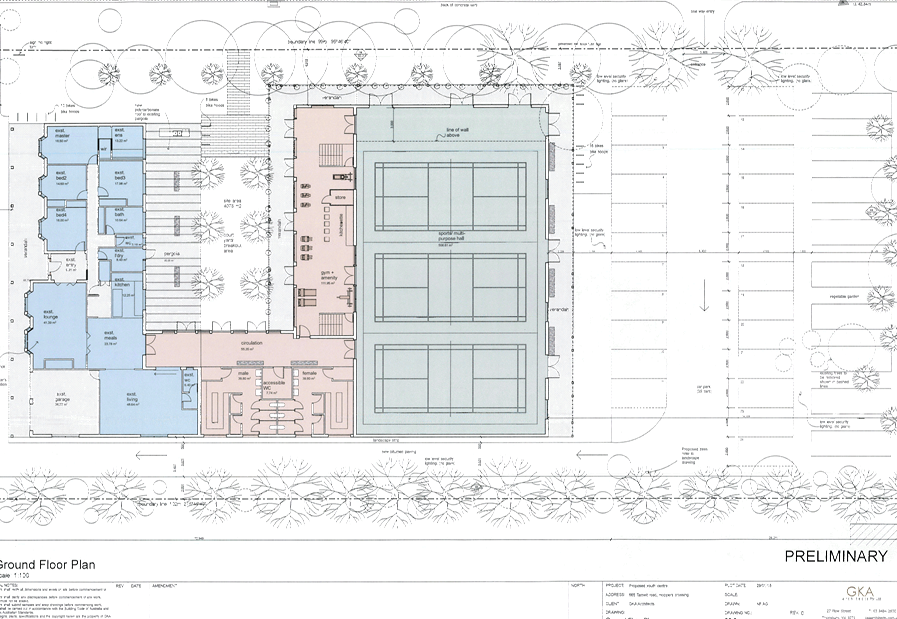
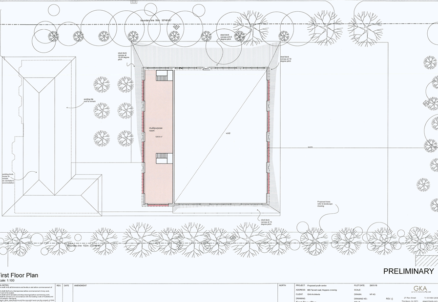
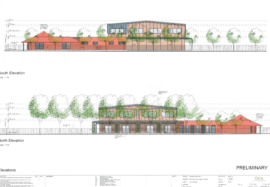
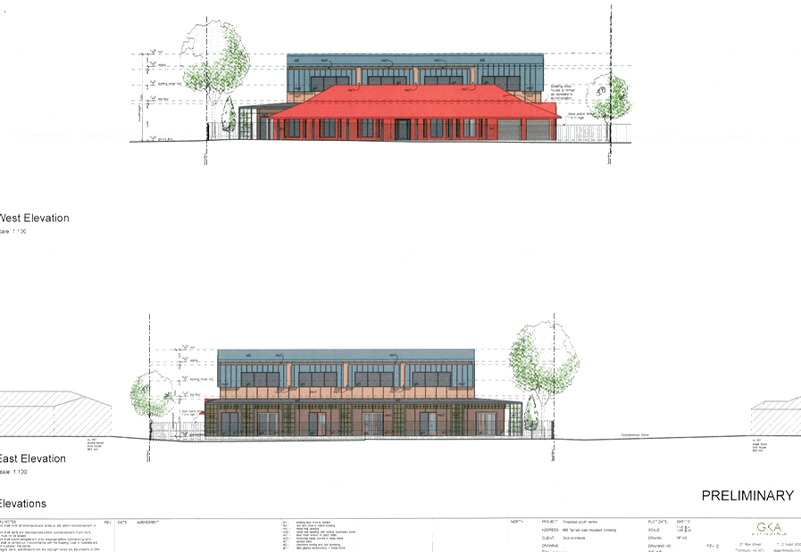
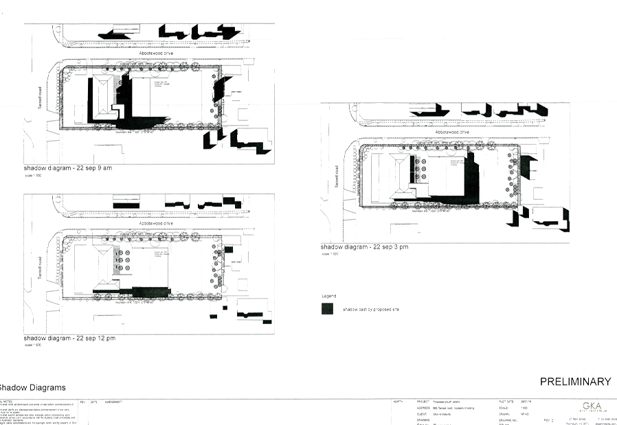
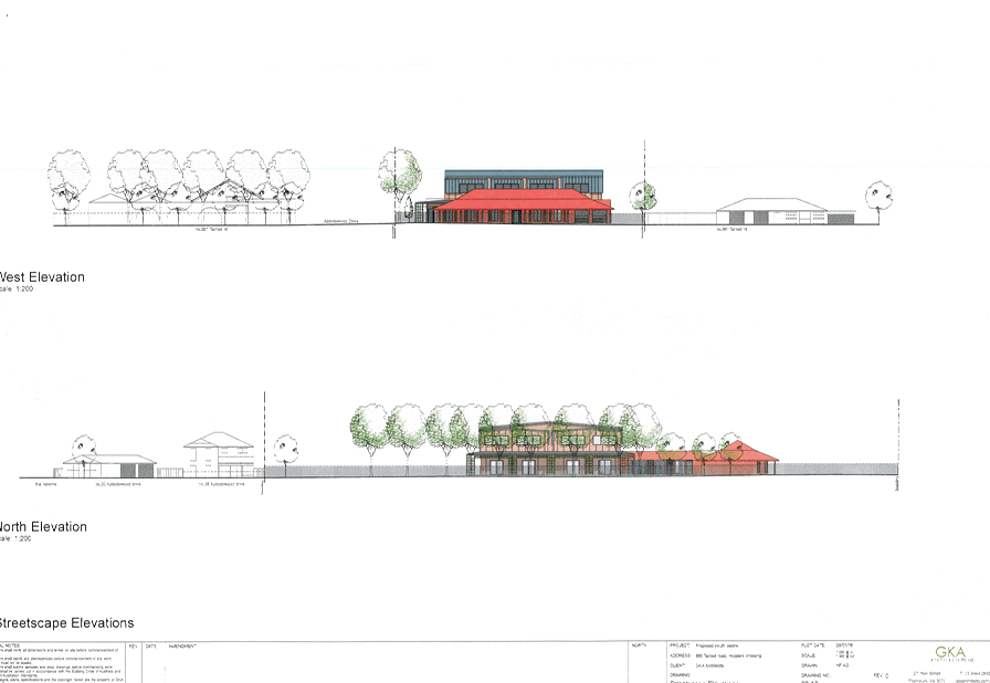
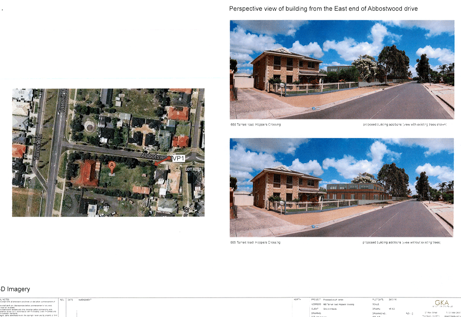
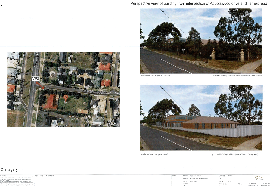
6.4.4 Planning Permit Application WYP8760/15 - 665 Tarneit Road Hoppers Crossing - Caretaker House, Place of Assembly and Indoor Recreation Facility 78
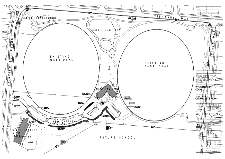
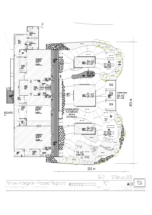
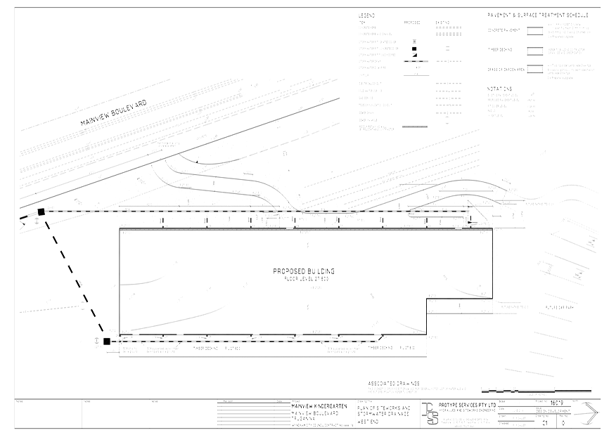
6.4.5 Planning Permit Application WYP9088/16 - 5 Vibrandia Way, Truganina - Kindergarten with Maternal Child Health 117
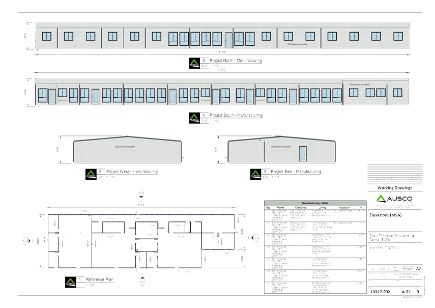
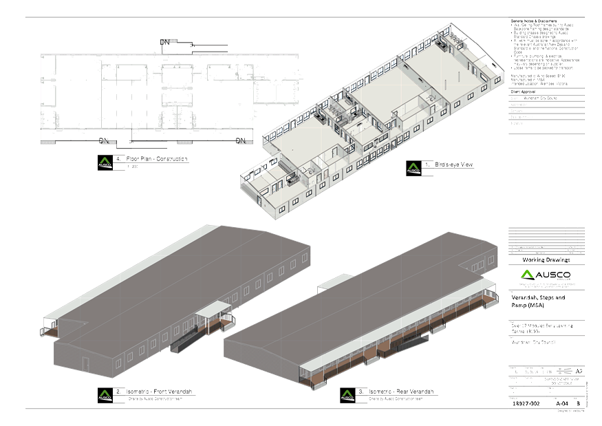
6.4.6 Planning Permit Application WYP9089/16 - 5 Vibrandia Way, Truganina - Sports Pavilion 149
6.5 Other Reports
6.5.1 Consideration of Submissions Regarding Council's Proposed Integrated Plan & Budget 2016/17 171
6.5.2 Adoption of Council's Integrated Plan & Budget 2016/2017 175
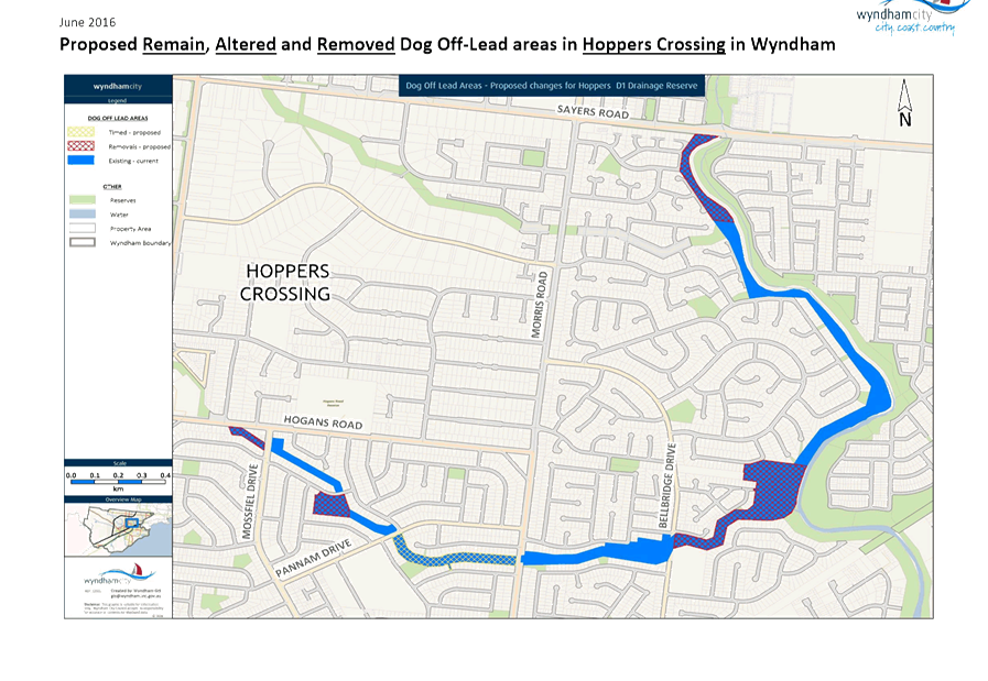
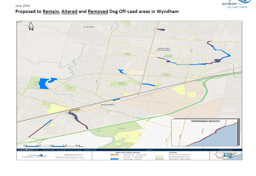
6.5.3 Dog Off Lead Order - 2016 185
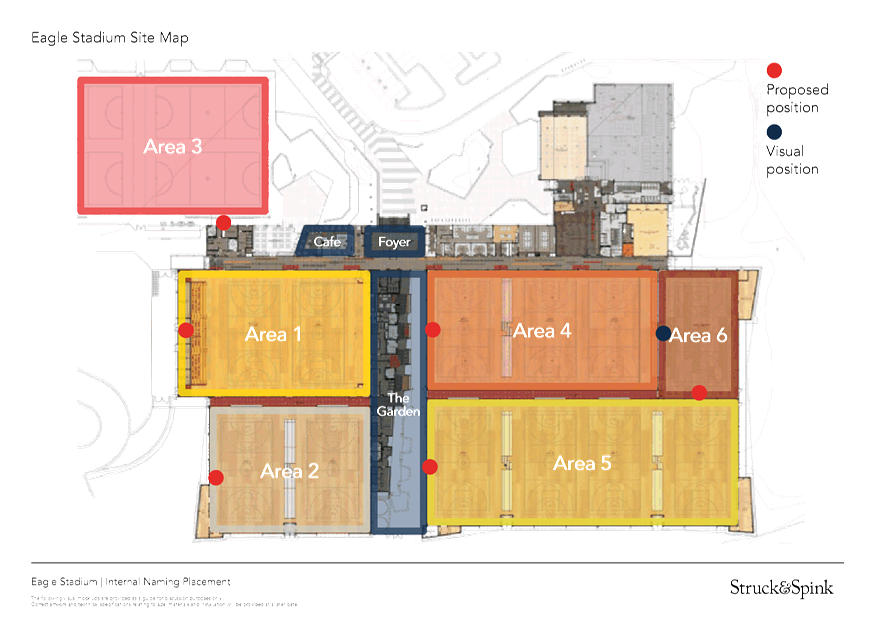
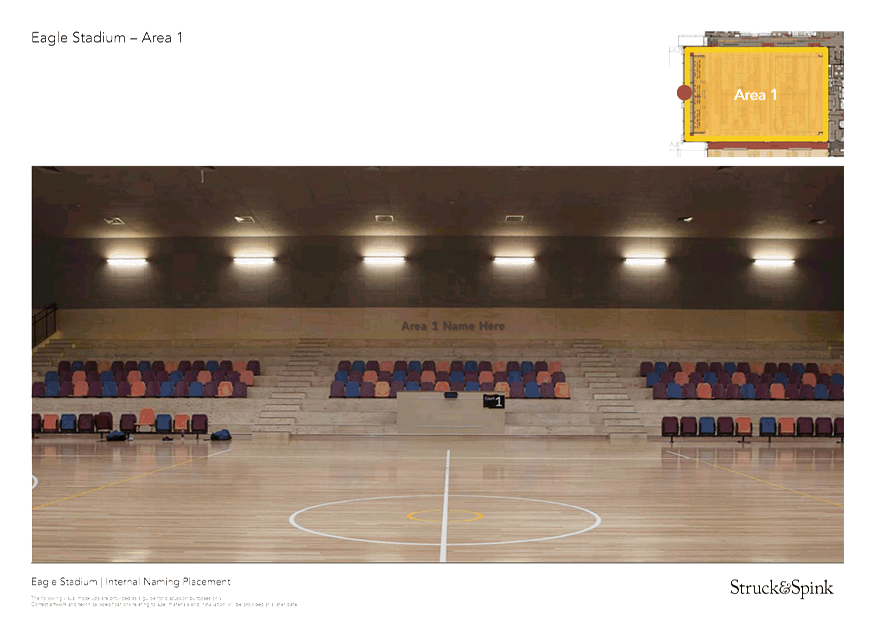
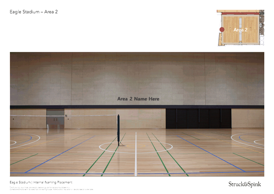
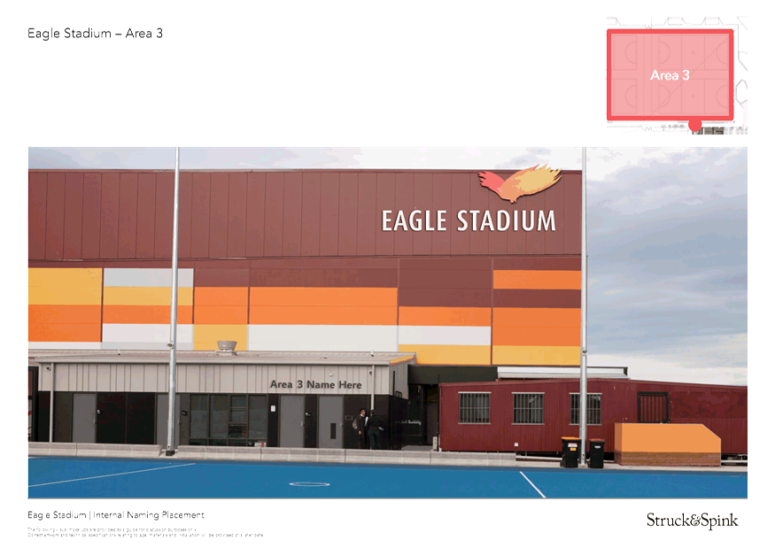
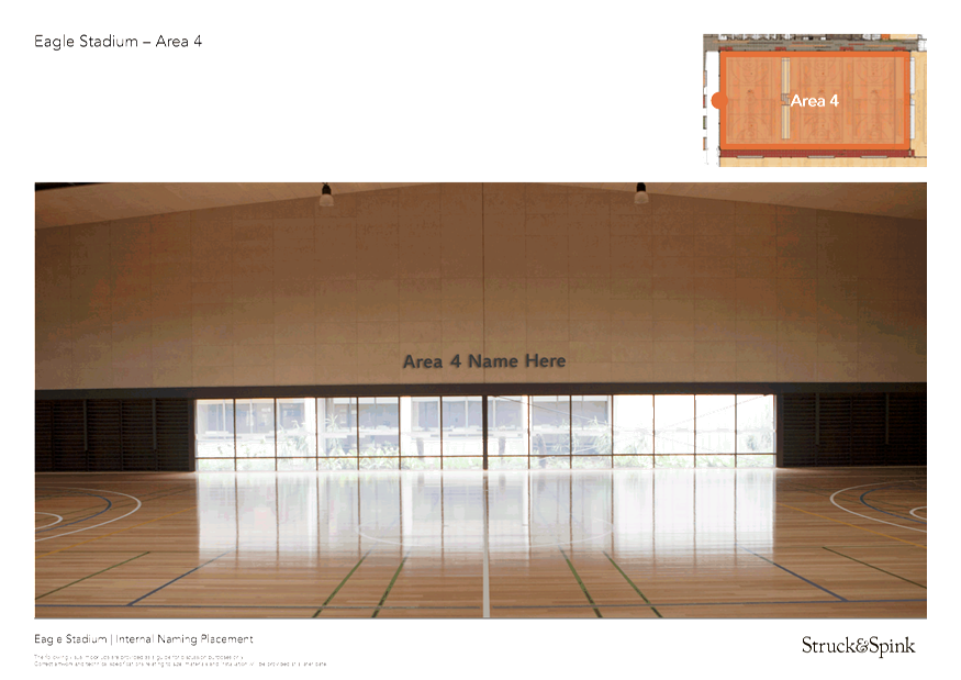
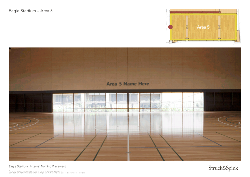
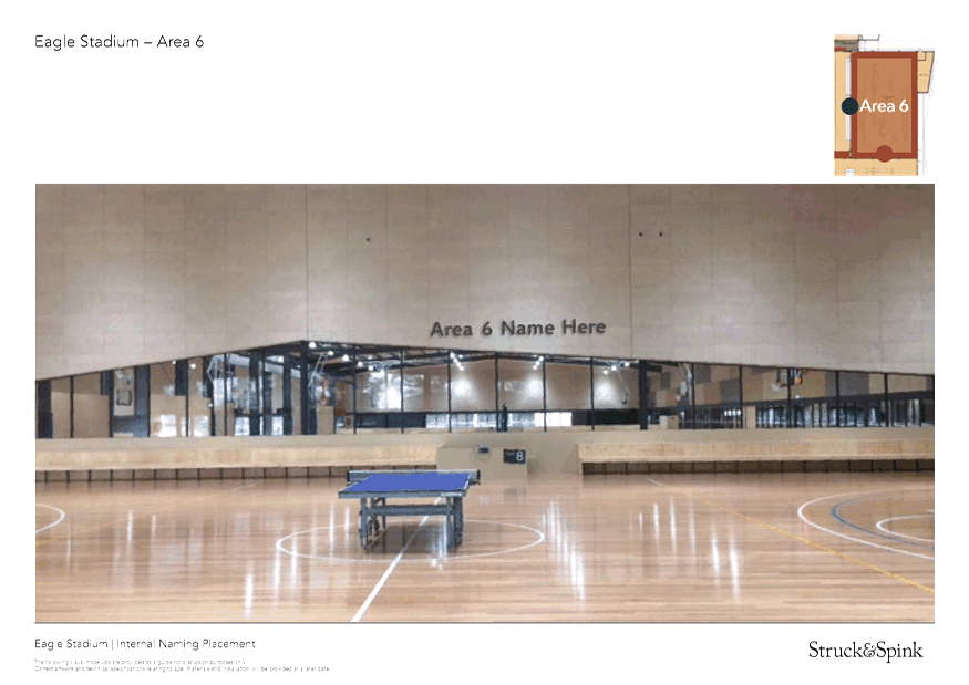
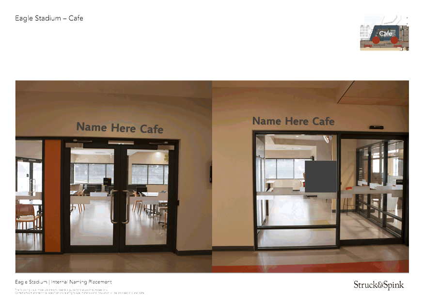
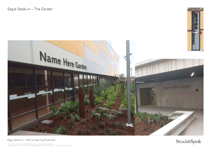
6.5.4 Eagle Stadium Internal Naming Components Proposed Names 197
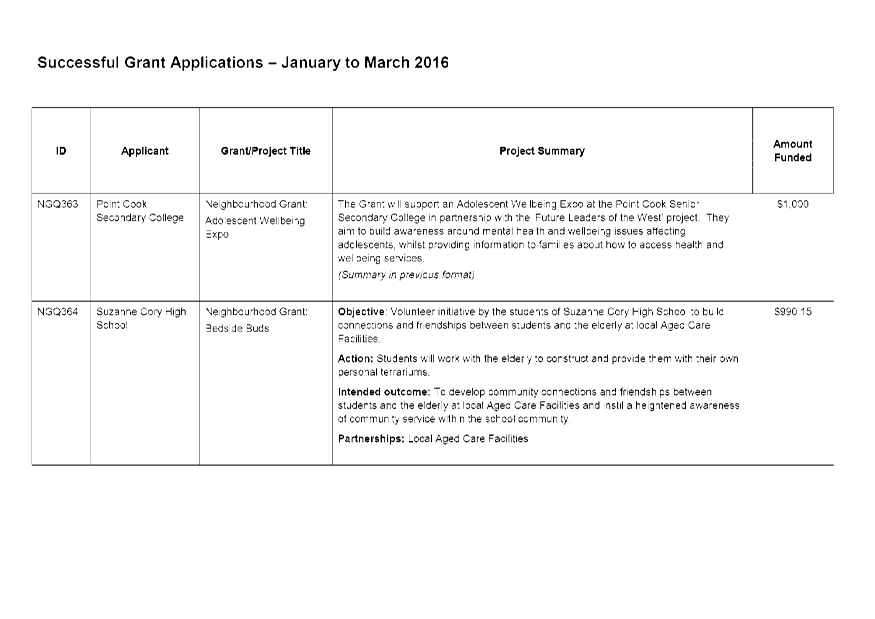
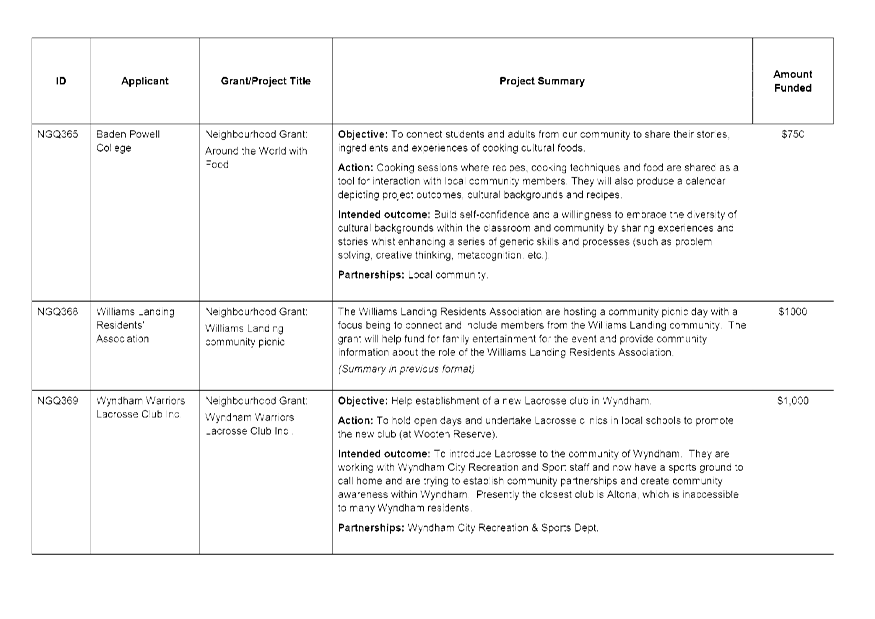
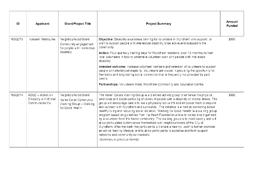
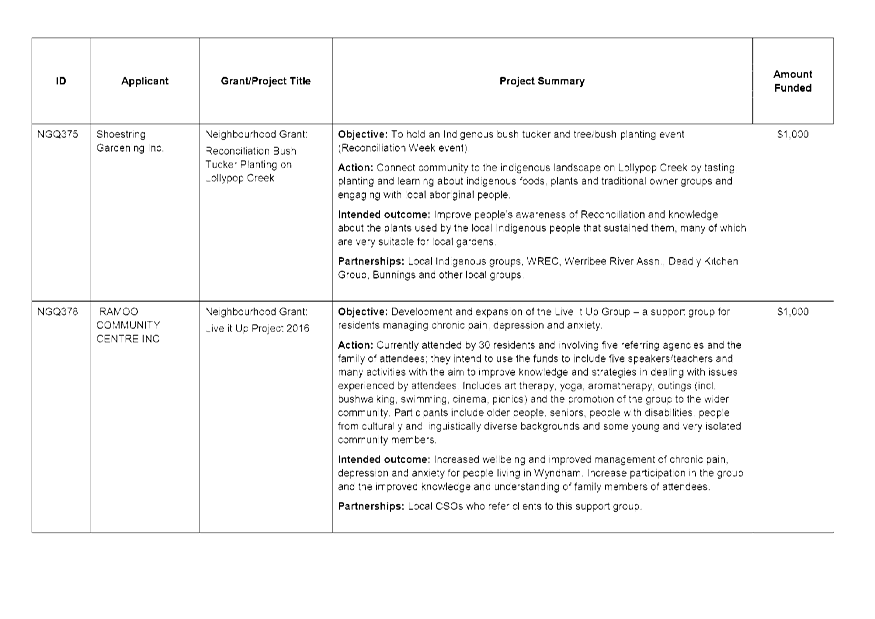
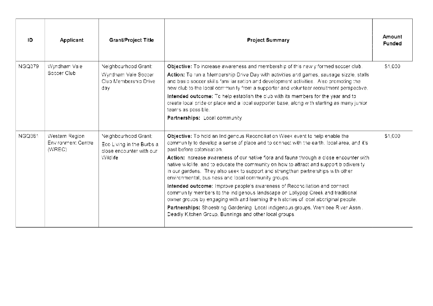
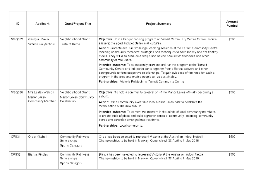
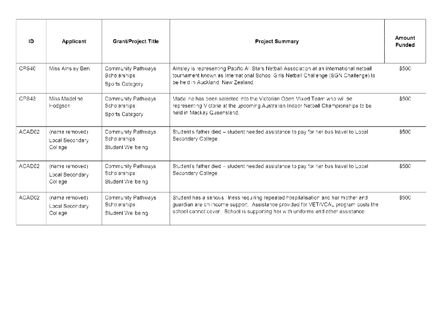
6.5.5 Quarterly Service Report - Grants - January to March 2016 215
6.5.6 Quarterly Service Report - Kindergarten Services - January to March 2016 226
6.5.7 Assembly of Councillors - May 2016 232
6.5.8 Status of Reports Returning to Council 238
7. Notices of Motion
7.1 Notice of Motion 564 - Metropolitan Integrated Transport Planning 239
7.2 Notice of Motion 565 - Recruit Smarter: A Better Way To Do Business 241
8. Council Seal
8.1 Awarding of Contract: Road Marking 243
9. Contract Summary
9.1 Infrastructure Contract Summary Report 249
10. QUESTIONS WITH NOTICE FROM PUBLIC GALLERY 252
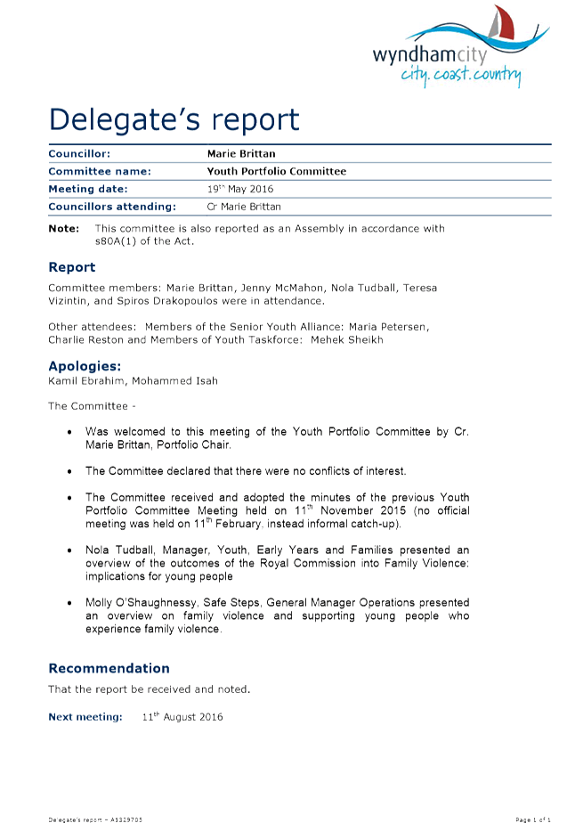
11. COUNCILLOR DELEGATES REPORTS
11.1 Councillor Delegates Reports 255
12. URGENT BUSINESS
13. CONFIDENTIAL BUSINESS
13.1 contractual matters 270
13.2 any matter which Council considers prejudicial to Council or any person 270
14. CLOSE OF MEETING
|
Strategic Reports |
|
Ordinary Council Meeting Monday, 27 June 2016 |
|
File No: 0
|
|
Item No: 6.2.1 Director Infrastructure - David Suder |
|
|
|
|
|
Wyndham Integrated Transport Policy and Wyndham Integrated Transport Strategy |
||
The final draft of the Wyndham Integrated Transport Policy (WITP) and Wyndham Integrated Transport Strategy (WITS) has been prepared in response to one of the most pressing concerns of residents in Wyndham - transport and traffic. The WITS is evidence-based and provides an overarching framework for local and regional transport planning, development and investment priority over time.
A major public consultation program occurred in March 2016.This report provides a summary of the public consultation feedback received and the associated changes made to the WITP and WITS. Minor changes were required to the content of the draft WITS in response to submissions. The majority of changes have focused on aligning the programs, actions and associated timelines.
This report seeks Council’s adoption of the final draft WITP and WITS as key documents that will assist in achieving the Wyndham 2040 Vision for transport, “Wyndham’s transport system will be efficient. People will be able to move around Wyndham easily. There will be more ways to connect to greater Melbourne.”
Attachments
|
1. |
Wyndham Integrated Transport Policy - Final Draft Policy - 2016-06-15 - printed in separate document |
|
2. |
Wyndham Integrated Transport Strategy - Final Draft Strategy - 2016-06-15 - printed in separate document |
Officers’ Declaration of Interests
Under Section 80C of the Local Government Act 1989 (as amended), officers providing advice
to Council must disclose any interests, including the type of interest.
Director Infrastructure - David Suder
In providing this advice as the Director, I have no disclosable interests in this report.
Acting Manager Traffic & Transport - Tim Cottrell
In providing this advice as the Manager, I have no disclosable interests in this report
Co-ordinator Transport Planning - Dean Ellis
In providing this advice as the Author, I have no disclosable interests in this report.
Key Issues
· Public Consultation Feedback
· Wyndham Integrated Transport Policy (WITP)
· Wyndham Integrated Transport Strategy (WITS)
RECOMMENDATION
That Council adopt the Wyndham Integrated Transport Policy (June 2016) and the Wyndham Integrated Transport Strategy (June 2016).
|
CRS Glenn Goodfellow / Intaj Khan
That Council adopt the Wyndham Integrated Transport Policy (June 2016) and the Wyndham Integrated Transport Strategy (June 2016). (CARRIED) |
1. Background
The development of the WITS has been divided into four phases:
· Phase One involved preparation of an Issues Paper containing the evidence base used to inform the development of the WITS.
· Phase Two involved drafting a Wyndham Integrated Transport Policy (WITP). The WITP Vision and Policy Statements were adopted by Council at the Ordinary Council Meeting on 26 October 2015.
· Phase Three involved revising the WITP and drafting a WITS (with targets, programs, actions, and timeframes). Following a review of the feedback, the draft final WITP and WITS have been prepared and is the basis of this report.
· Phase Four will develop an implementation plan for the actions and identify the monitoring needed to achieve the targets. This work will commence from late 2016.
2. Discussion
2.1 Public Consultation Feedback
There has been consultation and input at several levels during the course of the WITS project:
· There have been regular Project Working Group and Steering Group meetings to obtain internal, cross department input.
· Focused input from community representatives through the Transport Portfolio Committee and Transport Champions.
· Broad community consultation during two, one month periods to review both the Policy and Strategy.
Broad Community Input
Public consultation of the draft WITP occurred over August 2015 using an online survey, and received 104 responses. This survey only sought feedback from Wyndham residents, business, and local community groups. The results of this survey indicated that the community generally supported the Draft Transport Policy as presented. Many of the comments related to specific transport issues that were more relevant to the WITS development phase, rather than the policy.
The Draft WITS public consultation occurred over March 2016, and received 17 responses. Feedback was received from eight residents/local business/community groups, VicRoads, PTV, MPA, DEDJTR, RACV, CDC (Westrans), Avalon 2020, and two developers/consultants.
A brief summary of the feedback on WITS is:
· General comments on issues and the proposed targets, programs, and actions. They did not indicate major issues or concerns with the strategy. Changes have been incorporated as appropriate.
· Requesting one mode be prioritized over another. These comments were not supported as all modes are integral to the transport network in Wyndham.
· Raised issues that were already covered in other sections of WITS, by other Council strategies or policies, or addressed by other planning documents, e.g. Precinct Structure Plans.
· Requested more infrastructure or service levels for modes for which Council does not have responsibility. The WITS addresses these modes as requiring ongoing advocacy and consultation with State and Federal Governments.
· Raised issues that will need to be addressed in the strategies and projects that have been identified in the actions, e.g. Wyndham Walking Strategy.
· Wanted to see stronger targets set for Active and Public Transport modes. The Active Transport Target was amended. The other targets were not amended as they are considered to require considerable travel behaviour change by 2040.
· VicRoads had no identified issues but noting the VicRoads Corporate Plan, that there is general alignment with VicRoads planning and WITS.
· MPA was supportive, but noted that Council needed to take greater responsibility for actions rather than falling back on advocacy.
· DEDJTR noted that Plan Melbourne is currently being refreshed and that the aspiration to reduce peak travel times is supported. The role of sustainable transport and local job creation was stressed, as population growth will continue to place pressure on the arterial road network, even as the network matures through successive upgrades.
· PTV provided the most detailed submission. Their comments related to and provided significantly more detail on land uses and land management within WITS as well as acknowledging existing State Government plans and strategies such as the Network Development Plan – Metropolitan Rail (December 2012).
· The RACV took a collaborative approach to their comments. Whilst there were some minor changes recommended, their theme was to identify the areas they feel they can work on with Council. An example is that they have experience in rolling out electric vehicle charging stations at some facilities and some major tourist attractions/destinations. The RACV also focused on the need for clear measurable actions and targets to ensure better monitoring in the future.
All feedback, including the responses from August 2015, has been considered as input to the finalization of the WITS.
Council officers have indicated to submitters that they will receive an email when the WITP and WITS has been formally endorsed by Council. Included in the email will be a consolidated table of the feedback and the response from Council officers. Submitters will be offered the opportunity to meet and discuss this response with Council officers.
2.2 Wyndham Integrated Transport Policy (WITP)
(See Attachment 1, ‘Wyndham Integrated Transport Policy – Final Draft Policy- 2016-06-15’)
The draft WITP endorsed by Council for public consultation (22 February 2016 OCM) did not receive any feedback that required changes to the endorsed Vision and Policy Statements. Therefore, the changes to the draft final WITP have been to ensure any revised text in the draft final WITS have been captured in the WITP.
It is recommended that Council adopt the attached Wyndham Integrated Transport Policy.
2.3 Wyndham Integrated Transport Strategy (WITS)
(See Attachment 2, ‘Wyndham Integrated Transport Strategy – Final Draft Strategy- 2016-06-15’)
The basic structure of the final WITS is unchanged from the publically exhibited version. The following is a brief summary of the changes that were made following consideration of the submissions indicated in Section 2.1.
· The ‘Wyndham Target’ for walking and cycling has been amended to state, ‘Proportion of mode share’ to triple by 2040. Without this change, tripling walking and cycling would have been nearly achieved just through population growth.
· Where greater clarity was requested in the WITS, this has been incorporated. For example, ensuring only the major Activity Centres are shown in Figures 3 & 5, and adding definitions as footnotes.
· There has been greater recognition of State agency planning and provision. An example of this is reference to PTV’s Network Development Plan – Metropolitan Rail.
· A greater recognition of traffic congestion impacting upon public transport and the need for bus priority measures and improved access to bus stops.
· Under each ‘Wyndham Target’, each Program has been clearly linked to a supporting Action(s) and Timeframe.
The final draft WITS attached to this report is complete in regards to content, but a publication layout version is still being finalized. The final publication layout version of the WITS will be available prior to the formal launch, proposed to occur in July.
It is recommended that Council adopt the attached Wyndham Integrated Transport Strategy.
3. City Plan
The Wyndham 2040 Vision for transport is, “Wyndham’s transport system will be efficient. People will be able to move around Wyndham easily. There will be more ways to connect to greater Melbourne.”
The City Plan 2013-2017, Theme 2 ‘Place: Strong identity and managed growth’ and its associated objective of ‘Sustainable Growth’ is relevant to this report:
2.3 Sustainable Growth - To ensure Wyndham's population growth is matched by the development of new physical, social and economic infrastructure, while protecting the City's existing assets and natural environment.
The Wyndham City Integrated Plan & Budget 2015/16 includes Initiative 14, which is to prepare the WITS.
4. Council Policy
Council’s Municipal Strategic Statement Transport objectives at Clause 21.09 are:
· To improve and upgrade transport infrastructure to meet existing and future population growth.
· To provide safe walking and cycling routes to connect people to destinations.
· To provide for the safe, efficient and effective operation of public transport.
5. Financial Implications
The preparation of the WITS to date has been achieved through existing staff resources and two personnel on short term engagements to assist with drafting the documents. The cost of the consultants has been from the additional funds allocated in the 2015/16 budget for targeted work required to assist in completing and/or implementing the WITS.
6. Social Implications
In addition to the Wyndham 2040 Vision for transport, the following Wyndham Community Health Wellbeing and Safety Plan 2013-2017 key priority areas have been considered:
· A City Built for Health, Wellbeing and Safety: A city that is planned and built to support long term community health, wellbeing and safety.
· A Safe and Confident City: A city in which people feel confident to move freely and where they feel safe and secure in their homes.
Issues such as safety, accessibility, equity and sense of community can all be enhanced by an integrated transport network.The WITS has been developed in the context of these existing policies and taken into account the social needs of all people.
7. Environmental Implications
The WITS addresses the City Plan and Municipal Strategic Statement visions and objectives through actions aimed to minimize urban congestion, energy use and ‘greenhouse’ impacts. Consideration has also been given to the Environment & Sustainability Strategy 2016-2040 topic statement on transport:
· With rapid population growth and development pressures, Wyndham’s road network is increasingly congested, driving the need for more sustainable transport options and alternative ways to travel across, in and out of the City.
At present, the dominant environmental impact of transport remains with road use. A wide range of proposals is intended to increase active and public transport travel, and moderate the need for motor vehicle use. However, there are major barriers to the scope reducing motor vehicle use in growth corridors in real numbers and it will remain the dominant mode of transport in Wyndham.
8. Economic/Employment Considerations
The WITS will guide the development of an integrated transport network to provide for a range of public and private transport modes. This network will be planned to support the economic viability of Wyndham as a community by its internal permeability and links to surrounding communities. This will be especially important for freight movement, by road and rail, as Wyndham’s contribution to the State and National economy depends heavily on freight movement.
As sections of the network are upgraded to meet demand, it will progressively improve access to community services, employment opportunities, and public transport services, and assist in attracting further investment. The ongoing construction of a program of transport projects will also require investment and create jobs.
9. Communication Strategy
Submitters to the draft WITS will be notified by email when the WITP and WITS has been formally endorsed by Council and provided with the opportunity to discuss the Council officer response to their submission.
|
Policy/Advocacy |
|
Ordinary Council Meeting Monday, 27 June 2016 |
|
File No: Procurement Policy
|
|
Item No: 6.3.1 Director Corporate Services - Steven Lambert |
|
|
|
|
|
Procurement Policy Review June 2016 |
||
Section 186(A) (7) of the Local Government Act 1989 states a review of Council’s Procurement Policy must be undertaken at least once in each financial year and in accordance with this section Council may amend the policy if required.
This report presents a revised Procurement Policy for consideration and adoption by Council.
Attachments
|
1. |
Procurement Policy June 2016 - printed in separate document |
Officers’ Declaration of Interests
Under Section 80C of the Local Government Act 1989 (as amended), officers providing advice
to Council must disclose any interests, including the type of interest.
Director Corporate Services - Steven Lambert
In providing this advice as the Director, I have no disclosable interests in this report.
Manager Financial Services - Binda Gokhale
In providing this advice as the Manager, I have no disclosable interests in this report.
Co-ordinator Procurement - Shaun Collins
In providing this advice as the Author, I have no disclosable interests in this report.
Key Issues
· Compliance with the Local Government Act 198 Section 186A (7).
|
RECOMMENDATION That Council adopts the revised Procurement Policy dated June 2016.
|
|
CRS Intaj Khan / Marie Brittan That Council adopts the revised Procurement Policy dated June 2016. (CARRIED) |
1. Background
Section 186A of the Local Government Act 1989 requires Council to prepare and approve a Procurement Policy and at least once in each financial year review the policy and make amendments if required.
The current policy based on the MAV Model Procurement Policy was adopted by Council in October 2009 with additional changes and updates last made in May 2015.
2. Discussion
The annual review of Wyndham City Councils Procurement Policy commenced on 23 March 2016. The review invited comments, feedback and suggestions from Directors, Managers, Team Leaders and associated staff members as to how the policy could be improved or clarified where required. Submissions closed on 22 April 2016 with follow-up discussions with all who submitted a response. All amendments included in the revised policy are a result of those discussions in order to assist and clarify procurement responsibilities for all Council Officers.
In addition to the policy review and to support Council’s ongoing focus on sustainable procurement, the inclusion of an environmental questionnaire previously designated for Capital Works Projects (Procurement Policy May 2015) will now be extended to all major procurement processes to assist in delivering Council’s sustainable procurement targets as outlined in the Wyndham City Environment and Sustainability Strategy 2016 -2040 and the Green Procurement Action Plan.
3. City Plan/QCP
5.1 Good Governance - To maintain community confidence in the integrity and efficiency of the organisation. To continue to ensure there is a focus and commitment to transparency and accountability in Council decision making processes.
4. Council Policy
Councils Procurement Policy and processes are reviewed on a regular basis in line with the Victorian Local Government Best Practice Procurement Guidelines 2013 and the requirements of Section 186A of the Local Government Act.
5. Financial Implications
Council’s procurement activities are carried on the basis of value for money.
6. Environmental Implications
The inclusion of an environmental questionnaire in all major procurement processes will assist Council in meeting sustainable procurement targets.
7. Communication Strategy
Policy changes and updates will be communicated to all Council officers undertaking procurement activities within Council.
|
Policy/Advocacy |
|
Ordinary Council Meeting Monday, 27 June 2016 |
|
File No: 0000
|
|
Item No: 6.3.2 Director Advocacy - Bill Forrest |
|
|
|
|
|
Residential Growth Management Strategy Review and Update |
||
In 2012 Council adopted a Growth Management Strategy, which sought to provide direction for managing residential growth in Wyndham in a way that aims to overcome barriers to the timely delivery of infrastructure and services reasonably expected to secure a continuing high quality of life in Wyndham.
In 2015 Council commissioned SGS Economics and Planning to undertake a review and update of the Strategy, having regard for feedback from the community, development industry and government agencies, and the progression of government planning and infrastructure delivery policy in particular Plan Melbourne Refresh, and more recently “All things considered”, produced by Infrastructure Victoria as a step towards a 30 year infrastructure strategies for Victoria.
The Residential Growth Management Strategy (RGMS) lays out the:
· nature of the growth management challenge in Wyndham;
· policy and governance framework that influences growth management possibilities in Wyndham;
· solutions to promote mutually beneficial alignment between residential development and infrastructure provision; and
· outcomes to be expected from managing growth for different stakeholders, including the community, government and land developers.
It is structured to include chapters on:
· Wyndham’s growth challenge;
· Planning and infrastructure responsibilities: the governance framework;
· The role of density in managing growth;
· The role of sequencing in managing growth; and
· An approach to growth management.
Based on the evidence outlined in the report a strategy built around three themes is proposed as Council’s preferred means of managing residential growth;
· More active management of the number of growth funds under development at any one point in time,
· Strengthening the statutory controls to require higher densities in locations identified as appropriate in Council’s Housing Strategy, and
· Managing out of sequence development by requiring proponents to build viable communities and cover the costs of “bringing forward” necessary infrastructure and services.
It includes recommendations for both Council and the State Government. For Council these relate to giving statutory effect to the Housing Strategy, developing and adopting Project Implementation Plans (PIP) for infrastructure in Wyndham North and Wyndham West funded from developer contributions, working in partnership with other growth area councils, and the development industry in relation to secure Federal and State Government commitments to address infrastructure backlogs.
The State Government recommendations relate to improving regulatory frameworks to manage out of sequence development, local infrastructure delivery plans, indexation of development contributions, and a moratorium on any further work on residential precinct structure plans further than 3 km from an existing railway station.
Attachments
|
1. |
Residential Growth Management Strategy - printed in separate document |
|
2. |
Residential Growth Management Strategy Information Sheet - printed in separate document |
Officers’ Declaration of Interests
Under Section 80C of the Local Government Act 1989 (as amended), officers providing advice
to Council must disclose any interests, including the type of interest.
Director Advocacy - Bill Forrest
In providing this advice as the Director, I have no disclosable interests in this report.
Director Sustainable Development - Dean Rochfort
In providing this advice as the Director and Author, I have no disclosable interests in this report.
Manager Strategic Planning - Aaron Chiles
In providing this advice as the Manager and Author, I have no disclosable interests in this report.
Key Issues
· Timely provision of services and infrastructure given rapid residential growth.
· Better management of costs and timely infrastructure provision associated with out of sequence development.
· Addressing infrastructure backlogs.
· Securing higher density residential development in preferred locations.
|
RECOMMENDATION
That Council: 1. Adopt the revised and updated Residential Growth Management Strategy 2016 as attached to this report. 2. Adopt the recommendations to Council outlined in section 5.4 of the Strategy. 3. Write to the Minister for Planning, Metropolitan Planning Authority (MPA) and Department of Environment, Land, Water and Planning (DELWP) in relation to the recommendations of the State Government contained in section 5.5 of the Strategy.
|
|
CRS Bob Fairclough / John Gibbons
That Council: 1. Adopt the revised and updated Residential Growth Management Strategy 2016 as attached to this report. 2. Adopt the recommendations to Council outlined in section 5.4 of the Strategy. 3. Write to the Minister for Planning, Metropolitan Planning Authority (MPA) and Department of Environment, Land, Water and Planning (DELWP) in relation to the recommendations of the State Government contained in section 5.5 of the Strategy. (CARRIED) |
1. Background
Wyndham was the fastest growing municipality in Victoria between 2006 and 2011. The population grew by close to 50,000 people in this period, with around 80 babies born each week and nearly 20 new residents moving in every day by 2011. While the rate of growth has not returned to the pace of 2011, the population continues to grow rapidly. It is projected to increase from around 165,000 in 2011 to over 465,000 in 2041 (Source: forecast.id and ABS). Furthermore, building permits enabling housing construction have been issued at an increasing rate since 2013 from 2,076 to 3,368 in 2015.
In 2012 Council identified rapid residential growth is a major concern to the community, to the extent that timely provision of infrastructure and services, and local job creation was not keeping pace with this growth. Council adopted a draft growth management strategy, and undertook consultation with the development industry prior to formally adopting a “Strategy for Managing Growth in Wyndham” in June 2013. This Strategy identifies priorities for managing Australia’s fastest-growing municipality and its infrastructure needs. It identified the challenges as being:
1) A vibrant new city centre.
2) More local jobs.
3) Managing residential growth.
4) Getting quality urban design.
The goals for the strategy were identified as:
1) A great place to live.
2) A city with 10 suburbs by 2030.
3) Good public transport and roads.
4) Greater community infrastructure.
Since that time much work has been done on both the challenges and the goals including:
· structure planning, works and activation strategies for Werribee City Centre;
· development of a housing strategy;
· development of neighbourhood character strategy and guidelines;
· continued implementation of the economic development strategy; and
· the development of the Wyndham 2040 Vision.
The Strategy identified the growth rates of over 5000 new dwellings per year were unsustainable and indicated that a rate of 3000 or less, was manageable. The document was primarily an advocacy document as Council does not have the statutory powers to limit the amount of residential growth. Through 2014 the Strategy was the subject of intense scrutiny at Independent planning panels established to assess pressing structure plans and development contribution plans for Wyndham north and west. Recommendations arising from the work of the independent panels were not supportive of some of the work Council had undertaken within the Strategy to determine how residential growth should be sequenced. The Panel recommended further work by Council and the MPA on the issue of managing the sequencing of residential growth and Council’s revised Strategy has had regard for this.
2. Discussion
2.1 Characterising the growth management challenge
The growth management problem facing Council and, indeed, State Government can be characterised as too little infrastructure chasing too much thinly spread development. A very large amount of land has been made development ready –in the statutory planning sense– through the PSP process. This potentially gives Wyndham, and Victoria, a major advantage in terms of housing affordability. However, this prodigious expanse of development opportunities opens up the reality of multiple, simultaneous growth fronts. The Strategy identifies (see figure 15) over 20 “development fronts” simultaneously under development. The thresholds for the delivery of all manner of infrastructure items are being exceeded almost daily in multiple locations, but the funding and delivery capacity of Council and State Government agencies alike can cope with only a handful of such fronts in any given period.
High growth has increased demand for services and infrastructure, though provision has not kept pace with community needs. Development occurring in Wyndham has been heavily skewed towards housing, this has produced a poor quantum and mix of local jobs and services. This means, for example, that families travel longer to reach schools and places of employment in Wyndham compared to the rest of Melbourne. It also means that people living in some neighbourhoods do not enjoy convenient access to basic services like public transport and schools.
The main reasons that infrastructure supply has not met demand relates to a funding gap and the misalignment in timing between the pace and distribution of residential expansion and the rollout of infrastructure. In essence, suburbs are usually built before infrastructure - such as schools, parks, community centres and health clinics - is financially viable for governments to deliver. It isn’t financially feasible under current policy arrangements because insufficient revenue is raised to bring infrastructure plans forward in areas of greenfield expansion. This produces backlogs in delivery or high costs to bring infrastructure delivery forward.
The financial viability of infrastructure provision is undermined not only by the misalignment in pace of urban expansion and infrastructure planning, but also because of the geographic spread of new development fronts.
2.2 The preferred strategy for managing growth
For the benefit of future and current residents of Wyndham, as well as to contribute to an orderly and efficient development of the entire metropolitan area, it is important to have an effective residential growth management strategy in place.
All three levels of government - Local, State and Federal - and non-government sectors have a critical part to play in managing residential growth in Wyndham: Council needs to ensure that each suburb is appropriately planned and provided with access to local infrastructure and services; State and Federal Governments have an essential role in delivering city-shaping infrastructure and setting strategic policy frameworks that enable high-quality development outcomes; and developers play an important role in delivering urban development in optimum timeframes with high quality design and good access to services.
Based on the evidence and analysis in this report and the opportunities for Council to effect change within current governance settings, the preferred residential growth management strategy for Wyndham comprises three key elements:
1) Actively manage the number of areas under development at any one time to optimise the capacity to provide infrastructure in a timely manner. The primary vehicle for achieving this will be the ‘benchmark sequence of development’ preferably agreed between Council and State Government agencies. The sequence developed in this RGMS is based only on Council’s roads, community infrastructure and parks staging plans. This should be refined over time to incorporate Council’s infrastructure planning updates (planned for mid-2016) as well as State Government policy and infrastructure plans, for example, through the proposed “local infrastructure delivery plans” (DEWLP, 2015). This will ensure that the sequence reflects infrastructure planning at both the local and state level. Furthermore, Council should pursue greater regulatory tools to manage this and financial incentives to develop “in sequence” and disincentives to develop “out-of-sequence”.
2) Within this benchmark sequence, transition development to higher densities in areas with good public transport access, consistent with Council’s adopted Housing Policy. At present, Plan Melbourne is under review and one possibility under consideration is an increase to overall average densities from 15 to 25 dwellings per hectare (Plan Melbourne Refresh, 2015). Council’s Housing Strategy promotes an overall average density of over 20 dwellings per hectare (See figure 7 in the Strategy and the Housing Strategy Overview on page 28), - achieved by targeting an increase in infill in designated areas and substantially increasing densities around major transport and employment nodes.
3) Manage out-of-sequence development by requiring proponents to build viable communities and compensate for additional costs associated with bringing forward infrastructure. In this regard, the benchmark sequence established between Council and the State Government will set the standard for the most cost efficient and coordinated approach to delivering infrastructure. When a proposed variation from the agreed sequence is anticipated to cause extra costs, proponents would be required to prepare cost impact assessments for any agencies which see a prima facie need for such an assessment. Then, the method of compensation for any additional costs would be a matter of negotiation between the proponent and the affected agencies.
Sound Metropolitan strategy
Local governments are impacted by the changing landscape of metropolitan planning. The Victorian Government, through executive powers vested with the Planning Minister, has overall responsibility for metropolitan planning. The previous planning Minister delegated planning power for the Wyndham growth area to the Metropolitan Planning Authority (MPA). Under this arrangement, Council is closely consulted but has no final powers in the strategic planning undertaken for new communities.
A revision process has commenced since the release of Plan Melbourne in 2014. The Plan Melbourne Refresh recommendations indicate a renewed focus on ‘structured sequencing’ and ‘integrated infrastructure delivery’. Many of the proposed revisions promote a more compact metropolitan development pattern, for example with a 30/70 split of accommodating growth in greenfield/infill locations. Furthermore, the Plan Melbourne Refresh recommendations, currently being considered by the State Government, promote development staging and increased densities in growth areas, including to:
• investigate a mechanism to manage the sequence and density of the remaining PSPs based on land supply needs (36B);
• sequence and stage development …(and)…require that PSPs include a sequencing plan for new suburbs that link the timing of delivery of essential community infrastructure identified in a DCP to the anticipated staging of development….apply an appropriate mechanism that does not allow any subsequent stages to proceed until such time as these facilities and services are operational (recommendation 22, initiative 2.2.5);
• use a combination of a sequencing plan linked to capping or limiting subdivision and development approvals, DCP expenditure, council funded works, and works-in-kind delivery of infrastructure funded by DCPs (initiative 2.2.5-3); and
• amend the PSP Guidelines and SPP Framework mandating greater housing diversity and minimum dwelling density in the urban growth areas of 25 dwellings per net hectare for residential areas to meet the needs of all household types (initiative 2.2.5-4).
Finalisation of the refresh process is due in mid to late 2016. While the exact details of the revised Plan Melbourne are currently unknown, the refresh process under way indicates that there is commitment to address the misalignment between infrastructure delivery and new residential development in a way that improves quality of life outcomes for households and enhances coordination between different delivery agencies. This RGMS has been framed by this sentiment and offers a clear approach to operationalise Plan Melbourne’s objectives in terms of coordinating infrastructure delivery.
As part of the Plan Melbourne refresh process, Background Paper 1 ‘Managing Growth: Infrastructure for Melbourne’s Outer Suburbs’ has also been released. The Background Paper sets out a threefold approach to addressing growth pressures in outer areas, including:
1) improved coordination of future funding for infrastructure between different levels of government;
2) better planning for growth; and
3) increased State Government investment.
One key mechanism put forward to improve growth management is to develop ‘local infrastructure delivery plans’, which are envisaged as collaborative plans between State and Local governments. The approach to managing growth established in this RGMS responds to the directions of the Plan Melbourne Refresh.
2.3 Housing affordability
There are two elements of the Strategy that result in concerns about housing affordability. Firstly, managing the sequencing of residential growth, and the number of residential growth fronts under development simultaneously, often raises concerns from the development industry about restricted supply impacting on housing affordability. Secondly, concerns are raised about the impact of increasing development contributions on housing affordability.
The analysis undertaken to inform the Strategy indicates there is not a housing supply problem, and the actions proposed in the Strategy will not constrain supply to the point that impacts on affordability. The current lot supply situation (see Table 2 in the Strategy) is generous with 78,807 home sites currently vacant, already approved or planned for in Wyndham. This includes lots within existing PSPs and outside of PSPs. It does not include lots that are anticipated to be added by non-gazetted PSPs. These home sites are mainly located in the suburbs of Point Cook, Tarneit, Truganina, Wyndham Vale/Manor Lakes, Hoppers Crossing and Werribee.
These new areas provide approximately another 23 years housing supply based on the average growth rate. Furthermore, 22,666 lots are anticipated to be added by non-gazetted PSPs which will provide a further 7 years supply. The current strong lot supply of already approved PSPs means these new development areas will not start for some years OR there is the prospect of disjointed, piecemeal development across the municipality, accompanied by extra costs. If the density targets proposed in the Housing Strategy were met, land supply requirements would be reduced even further and this is detailed in section 3.3 and 4.2 of the Strategy.
In regard to development contributions, the Strategy contains comparative data produced by the Productivity Commission (see figure 6) which shows development contributions in Greenfields areas in Melbourne is substantially lower than contributions in Brisbane Sydney and Perth.
2.4 Identifying a benchmark sequence of development
The RGMS contains a macro staging plan, intended to focus down from the broad level, and work in conjunction with “bottom-up” plan contained within the Wyndham North project implementation plan (PIP).
The benchmark sequence of development across the PSPs in Wyndham should be closely linked to the upgrade of key road segments. This is not because road infrastructure is more important than other essential community needs, but rather that roads tend to be amongst the most expensive items in the suite of assets required to set up new communities and, moreover, they are required to physically render land developable at urban densities. The benchmark sequence of development has been developed into a macro-staging plan.
The macro-staging plan in this RGMS (See Figure 10) incorporates roads as well as local community infrastructure and open space. It has also been adjusted to reflect current residential development patterns and subdivision approvals. This staging plan should be updated over time in consultation with State Government departments and agencies to determine the preferred sequence based on the combination of local and state infrastructure, like sanitation and school infrastructure. While Figure 10 presents the macro-staging plan at 25 dwelling units per hectare, Figure 9 represents a macro-staging plan at PSP densities (15 dwelling units per hectare) as a past point of reference. This reiterates the function of density in managing growth and is an important consideration in sequencing development and infrastructure.
The Strategy contains a methodology for determining the sequencing of these roads segments and as a result of this the costs of “bringing forward” elements to service out of sequence development. The Strategy recommends this form the basis of further work with state agencies to incorporate other elements of infrastructure that would be required to service out of sequence development. The Strategy therefore seeks to be transparent about the costs of a sequence development and have these incorporated into overall development costs, rather than have isolated communities develop with inadequate services and infrastructure. Those communities then bear the social and broader economic costs of poorly serviced residential development. Governments (in effect ratepayers and taxpayers) have not been willing to bear the cost of bringing this infrastructure forward, as evidenced by our infrastructure backlogs.
Cross-references to the “micro-staging” works undertaken through the Wyndham North PIP are referenced in section 4.4 of the Strategy.
2.5 Possible options for growth management
Putting a brake on development might suggest itself as an option. However, the forces that are driving population growth in the City are well beyond the capacity of Council to control. Moreover, the stage has already been set for continuing rapid growth. This is evident in the preparation of PSPs, which map out in very broad terms where urban expansion is to occur. Unfortunately, the PSP’s already approved in Wyndham do this without guidance on a preferred sequence of land release, as identified in the SPPF, that would assist with the delivery of timely and adequate provision of public transport and local and regional infrastructure. Rolling back the clock is unlikely.
Another obvious option is to secure additional Commonwealth and State Government capital funding for infrastructure. This is being actively pursued by Council in its own right and through various peak groups, like the Interface Group of Councils and the National Growth Areas Alliance. There have been successes from time to time on this front, depending on the political cycle, but a shift to more structural reforms – as distinct from specific project funding – seems illusive. The work needs to continue in this area, but it cannot be relied upon to fix the problem.
Turning to options which are more in the bailiwick of Council (though by no means exclusively so), four possible, non-mutually exclusive strategies are to:
1) Gear development to infrastructure capacity;
2) Contain infrastructure costs per household by lifting densities;
3) Contain infrastructure costs through better sequencing of development; and
4) Drive down the costs of infrastructure.
The RGMS deals with the first 3, driving down the costs of infrastructure without compromising quality or supply is a separate piece of work.
3. City Plan/QCP
2.3 Sustainable Growth - To ensure Wyndham's population growth is matched by the development of new physical, social and economic infrastructure, while protecting the City's existing assets and natural environment.
The Wyndham 2040 vision “A Place for people” articulates our vision for places and spaces which includes, “our city will offer a diverse range of housing types and built environments to contribute to the quality of life for residents at all ages”.
4. Council Policy
The Strategy is consistent with the work Council has been undertaking in particular in relation to the municipal strategic statement, housing strategy, and the Wyndham north PIP.
Council’s Municipal Strategic Statement (MSS) has a policy basis “to achieve cost-effective and orderly management of urban growth.” A number of strategies to achieve this objective are set out in the Statement to achieve cost effective and orderly management of urban growth, including:
· Ensure that residential growth aligns with the delivery of key infrastructure items and the delivery of economic and employment growth;
· Provide for growth on a scale and form consistent with maintaining the containment, compactness, accessibility and affordability of key growth areas;
· Provide for new development to occur in areas that are not isolated from the core urban area and which integrate well with existing communities and infrastructure; and
· Support new development in areas where sufficient infrastructure can be provided.
5. Financial Implications
Implementation of the Strategy would reduce Council’s exposure to additional infrastructure costs to service new residential growth by seeking stronger government commitment and adjustments to development contributions.
6. Social Implications
The social implications of out of sequence and fragmented development is the social costs associated with delayed provision of infrastructure. There is also evidence contained in the Strategy that the implementation of densities outlined in Council’s Housing Strategy has a positive impact on public health, particularly associated with more active lifestyles with higher public transport provision associated with higher densities.
7. Environmental Implications
Less fragmented and out of sequence development results in less reliance on private motor vehicles and greater capacity to walk and cycle to services and use public transport, with associated environmental benefits.
8. Economic/Employment Considerations
Better management of the sequencing of residential growth delivers economic efficiencies.
9. Community Consultation
Community satisfaction surveys continue to highlight resident dissatisfaction regarding how well residential growth is managed.
Extensive community and key stakeholder consultation was undertaken in the development of the first residential growth management Strategy, and then subject to further extensive consultation with development interests through independent planning panel considerations, the details of which are contained in section 4.1 of the Strategy. Some key stakeholder consultation has occurred towards the conclusion of the review of the Strategy.
10. Communication Strategy
Attached to the report is an overview of the updated Strategy that will be used communication with interested residents.
The SGS report will be forwarded to residential develop interests and government agencies together with information regarding how Council would seek to collaborate with those agencies to implement the Strategy.
|
Policy/Advocacy |
|
Ordinary Council Meeting Monday, 27 June 2016 |
|
File No: 0000
|
|
Item No: 6.3.3 Director Advocacy - Bill Forrest |
|
|
|
|
|
Submission to Infrastructure Victoria "All things Considered" |
||
In late May Infrastructure Victoria (IV) produced a package of information focused on the development of a blueprint for 30 years of infrastructure planning and development in Victoria.
“All things considered – Exploring Options for Victoria’s 30 year Infrastructure Strategy” sets out the options being considered for Victoria’s 30-year infrastructure strategy. It supports the next stage of community consultation, which will culminate with the release of a draft strategy and then final strategy by the end of 2016.
The package consists of the following key documents:
· The “all things considered” overview document. This document provides a vision, objectives, and assessment of projects against 19 identified needs, the first of which is “Address infrastructure demands in areas with high population growth”;
· A “draft options” book that gives a brief overview of 236 projects;
· A funding and financing options discussion paper;
· Six technical reports produced by consultancies Deloittes, PwC, AECOM, Aurecon.
This report indicates that Council should welcome the work of Infrastructure Victoria, and the comprehensive nature of their approach to the task. Council also welcomes the strong focus on the needs of areas with rapid population growth.
This report highlights key issues in terms of the approach and methodology adopted by Infrastructure Victoria, and suggests a number of refinements and improvements. It also provides detailed responses to how projects are scoped and prioritised relative to needs Wyndham City has identified through its planning, policy and strategy work.
The focus of this Council report, and projects highlighted, is based upon priorities identified in Council plans and strategies, in particular the Advocacy Strategy, Wyndham Integrated Transport Strategy, Housing Strategy, Community Health and Well-being Plan. It is not possible in the short time available to provide a detailed response to all the projects that have implications for Wyndham.
It is recommended that Council endorse the attached submission.
Attachments
|
1. |
Submission - Infrastructure Victoria - printed in separate document |
Officer Declaration of Interests
Under Section 80C of the Local Government Act 1989 (as amended), officers providing advice
to Council must disclose any interests, including the type of interest.
Director Advocacy - Bill Forrest
In providing this advice as Author and the Director, I have no disclosable interests in this report.
Key Issues
· Provision of infrastructure to meet the needs of rapidly growing communities.
· The establishment of a suite of public policies and strategies to guide how infrastructure projects are to be prioritised.
· The establishment of targets and performance measurement framework to determine whether the vision and objectives are being met.
· Methods the consideration of better engagement with local government and consideration of local government built and managed infrastructure.
|
RECOMMENDATION
That Council: 1. Endorse the submission to Infrastructure Victoria in relation to “All Things Considered” that is attached to this report.
2. Forward a copy of the submission to all local members of State Parliament.
|
|
CRS Glenn Goodfellow / Gautam Gupta
That Council: 1. Endorse the submission to Infrastructure Victoria in relation to “All Things Considered” that is attached to this report.
2. Forward a copy of the submission to all local members of State Parliament.
(CARRIED) |
1. Background
Infrastructure Victoria is an independent statutory authority which will provide expert advice and guide decision making on Victoria’s infrastructure needs and priorities.
Infrastructure Victoria is undertaking the first ever 30-year infrastructure strategy for Victoria.
Infrastructure Victoria has three key roles:
1. Prepare a 30-year infrastructure strategy for Victoria;
2. Provide advice to the Victorian Government on infrastructure matters;
3. Publish research on infrastructure matters.
Infrastructure Victoria’s 30 year strategy will inform a 5 year plan produced and approved by the State Government.
Infrastructure Victoria is led by a board of seven members comprising four members from the private or non-government sectors, and three from the public sector (departmental secretaries).
2. Discussion
2.1 Process to develop a Strategy
The preparation of the 30-year infrastructure strategy is a significant undertaking. Infrastructure Victoria will take the following steps to develop the strategy:
· Goals - consider the economic, social and environmental objectives against which Victoria’s infrastructure needs will be assessed and consult on these objectives;
· Current assets and capabilities - assess Victoria’s current infrastructure assets and capabilities;
· Infrastructure challenges and opportunities - identify Victoria’s short, medium and long-term infrastructure needs. This will include review of existing agency strategies and plans, population projections, expert reports and economic data;
· Options – assess options to meet those needs including future trends, demands and technology changes, demand management and regulatory reform and considering whether to invest in new infrastructure or make better use of existing infrastructure;
· Strategy – a draft strategy will be published for a final round of public input prior to the release of the final strategy.
2.2 Vision and Objectives
The document contains a vision “that by 2046 we can see Victoria where everyone can access good jobs, education and services regardless of where they live, where communities are held together by strong bonds, where industries and businesses thrive, and where the environment is valued and protected”.
It also contains the following objectives:
· Prepare for population change;
· Foster healthy, safe and inclusive communities;
· Reduce disadvantage;
· Enable workforce participation;
· Lift productivity;
· Drive Victoria’s changing, globally integrated economy;
· Promote sustainable production and consumption;
· Protect and enhance natural environments;
· Advance climate change mitigation and adaptation;
· Build resilience to shocks.
2.3 Needs
“All Things Considered” makes the point that infrastructure is needed to deliver on social economic and environmental needs and is not an end in itself. 19 needs are identified 17 which have elements which are directly applicable in Wyndham:
1) Address infrastructure demands in areas with high population growth.
2) Address infrastructure challenges in areas with low or negative population growth.
3) Respond to increasing pressures on health infrastructure, particularly due to ageing.
4) Enable physical activity and participation.
5) Provide spaces where communities can come together.
6) Improve accessibility for people with mobility challenges.
7) Provide better access to housing for the most vulnerable Victorians.
8) Address expanded demand on the justice system.
9) Provide access to high-quality education infrastructure to support lifelong learning.
10) Meet growing demand for access to economic activity in central Melbourne.
11) Improve access to middle and outer metropolitan major employment centres.
12) Improve access to jobs and services for people in regional and rural areas.
13) Improve the efficiency of freight supply chains.
14) Manage threats to water security, particularly in regional and rural areas.
15) Manage pressures on landfill and waste recovery facilities.
16) Help preserve natural environments and minimise biodiversity loss.
17) Improve the health of waterways and coastal areas.
18) Transition to lower carbon energy supply and use.
19) Improve the resilience of critical infrastructure.
2.4 Assessing and prioritising projects
The document and has chapters on each of these 19 needs and a preliminary view on priority infrastructure projects to tackle these needs, as well as some considered but that did not pass through the initial “gateway” assessment.
Projects were first categorised according to three different types of assessment, rather than just build new infrastructure. These were:
· changing behaviour, managing demand;
· better use of existing assets; and
· expanding assets or building new ones.
Given the large number of options, each option was first assessed on its contribution to addressing the need. This was a measurement of whether an option made a significant (S), moderate (M), low (L) or very low to negative (VL/N) contribution to the need.
For those options that passed through the cost and contribution filter, Infrastructure Victoria also evaluated how they could influence a broad set of economic, social and environmental indicators. This presents us with a preliminary understanding of the broader impacts of one option, which we can then compare against other options. This assessment was used to determine the positive or negative economic, social and environmental impacts of an option, and these were evaluated on a case-by-case basis.
2.5 Consultation to date and the role of local government
The consultation timeframes, with the release the paper late May and expect feedback by 17 June, is unrealistically short for a document and process of such Statewide significance. “All Things Considered” sets the scene for a 30 year strategy and as such an 8 week period for consultation would be much more appropriate. It is recommended that a minimum period of 8 weeks be allowed for public consultation on the draft strategy before a final strategy is recommended to government/parliament. Many Councils formally meet only monthly and time should be allowed for Councils to formally resolve a position via a report to Council. Also the next consultation period should not fall within the “caretaker period” in the lead up to Council elections in October.
There are three paragraphs (p28 of the main report) given over to describing the role of local government, in nearly 1000 pages of documentation. The three paragraphs assert how critical local government’s role is (but don’t enunciate what that role is). The lack of any further attention to this, Including the value of Council assets and levels of infrastructure spending Councils are responsible for, combined with the short timeframes allowed for any response, undermines the sentiments outlined.
Local Government, broadly speaking, has 3 roles to play that warrant further articulation, recognition and consideration:
· As a funder, provider and manager of a significant amount of public infrastructure in Victoria, estimated to be worth $ 79B (Source: MAV).
· As a provider of infrastructure with some funding from or, a variety of partnerships with State and Federal Governments, particularly early years, community, arts, cultural and recreation facilities.
· As an advocate for, or representative of local needs, opinions and priorities regarding infrastructure provision
In relation to the funder/provider role, Council recommends Infrastructure Victoria put its mind to the implications of constraints being placed on Councils to sustain adequate levels of infrastructure investment to meet the needs identified by Infrastructure Victoria. These include the impacts of ratecapping, cost shifting, and statutory limits on other revenues such as development contributions and some fees and charges.
A Local Government Reference Group had been established comprising, as Council understands it, officer membership was drawn from MAV, VLGA, LGPro, LGV, and the cities of Casey, Dandenong, Bendigo and Ballarat. Council recommends the Reference Group continue and provide input regarding the responses to “all things considered” and how it is intended to feed this into the draft strategy. The reference group membership, terms of reference and deliberations should be made available to the sector for continuing comment and dialogue. Given a particular assessment criteria in the Options Paper of “Westside Story” recognizing the shift in population growth to Melbourne’s west, it is recommended that the local government reference group include representation for Melbourne’s west.
2.6 Methodological issues
Infrastructure Victoria makes the point that infrastructure is a means to an end, for example allowing people to move around freely, or providing facilities from which services such as health and education can be provided.
The submission attached outlines a number of issues related to survey methodology that ought to be addressed in developing the strategy. These include:
· working within a public policy framework – what government wants to do in relation to service provision – both types and levels of service, will influence infrastructure requirements. Currently this context for decision making appears to be lacking;
· measuring performance against vision and objectives set, including the setting of performance targets. For example if the purpose of providing transport infrastructure is to ease the burden of congestion then a target of the extent to which congestion is to be eased ought to be set. The cost of congestion is currently measured and anticipated to grow. A target could be an absolute reduction or a reduction in the cost or congestion relative to be rate of economic growth or employment growth;
· limitations to different assessment types – what’s happening in growth areas. The methodology outlined of changing behavior and managing demand, then making better utilization of existing assets before building new assets, understates the critical issue in growth areas of substantial undersupply of assets, particularly in other “needs” areas applicable to wind and other growth areas but not captured in need one “planning for rapid population growth;
· conceptualisation of the relationship between land-use planning and infrastructure provision:
o Land use planning and infrastructure planning, in growth areas, happens in a reasonably co-ordinated manner. Infrastructure Victoria asserts that it does not (p24), even in growth areas. Particularly in the growth areas, we have a good knowledge of what infrastructure needs to be provided in terms of transport, health, education, recreation, emergency services and the like, and when it should be provided. Those elements that are 100% funded and/or provided by the developer are delivered in a timely manner. Those infrastructure items requiring political decisions through budgets at all levels, but particularly at the State level, struggle to be delivered in a timely manner, if at all.
o Most of the big planning decisions are already centralised with the State particularly in relation to growth area planning.
o Addressing infrastructure demands in growth areas: - the planning is being done and the need is recognised, the problem is a lack of political will to adequately fund, and in a timely manner, the infrastructure required either via the tax base and budget allocations, or additional development contributions, or a combination of both.
· social and economic impact analysis - there is no reference to reducing inequality, as a measure of social need, which we know has both social and economic benefits, and should be included;
· addressing multiple needs and sectors - this appears to be overly simplified:
o Some infrastructure projects will meet more than one need, for example public transport projects improve access but also, as a form of active transport, deliver better public health outcomes.
o Transport projects also improve access to education.
· classification of projects – a large number of projects are described as having merit, but “require further development or are sufficiently developed but not yet assessed against this need”. It is important to understand which of the two categories described each project falls into. The document reads as though sufficiently developed projects that infrastructure Victoria has not yet had the opportunity to assess are being given a lower priority, including a number that Wyndham would view as critically important. The submission recommends that each project be classified as either requiring further development, or requiring further assessment, as the implications are quite different;
· Evidence to support project proposals. As part of this consultation process Infrastructure Victoria has requested documentary evidence to support project scoping and project priorities. It is therefore proposed that the following documentation accompany this submission:
o Traffic volumes in Wyndham;
o Wyndham Integrated Transport Strategy;
o Wyndham north PIP;
o Residential growth management strategy;
o Advocacy Strategy;
o Community Health and Well-being Plan;
o The Business Case for the H3 Housing and Homelessness Support Project;
o Grade Separation Removal Study by OPUS International.
Council’s submission focusses on projects that are consistent with adopted policies and strategies, and in addition to a specific response to “Need 1” are grouped according to the themes in Councils Advocacy Strategy.
3. Need 1 - Addressing infrastructure demands in areas with high population growth
Council welcomes the recognition that, whilst the needs are not ranked from 1 to 19 in priority order, there is a very strong emphasis throughout the document on this need/priority, namely the challenges associated with rapid population growth.
3.1 Better use of existing infrastructure
Four projects are categorized as “better use of existing infrastructure”, but there are a number of issues with these that are detailed in council submission. In summary they are;
· The centralized planning scheme project proposal, which as alluded to earlier in the report, misunderstands the extent to which growth area planning is already centralized, and the benefit centralization doesn’t bring at the moment in relation to provision of infrastructure.
· The growth areas bus service expansion project sets an unacceptably low standard of service provision at 20 min. If such a level of service provision was proposed for tram services there would be a public outcry, so it is difficult to see how such a low level of bus service is acceptable in growth areas. Bus services should be the same frequency as train services if we are to meet objectives around reducing the costs of congestion and sustaining high livability, improving productivity and access to jobs.
· The subregional infrastructure planning project, if growth corridors were defined as the sub regions would have merit but is something the Metropolitan planning authority has been working on the sometime with limited success. Unless there is a significant commitment from major state agencies at the central level and the Department of Treasury, implementation of these plans will remain problematic.
· Urban development (i.e. intensification) in existing urban areas, is proposed as a measure to reduce the pressure in growth areas. Over the past 2 to 3 decades metropolitan planning policy has proposed ratios of “infill” development relative to “green fields” development and these ratios have not been realised. Infrastructure Victoria recognized the political difficulties with this approach. It also does nothing to deal with the already existing infrastructure backlogs in growth areas.
3.2 New and expanded assets
Eight projects are listed under this category for need 1. The following comments are made in relation to the 3 that relate specifically to Wyndham:
· The arterial road network enhancement project focuses specifically on access to employment centres in growth areas. Whilst this is commendable and Werribee is included, it does not address the major backlog of arterial road duplication is required in growth areas. A copy of Councils traffic volumes report will be forwarded with this submission;
· The Melton rail electrification project is supported as additional services will relieve pressure on the Westgate Freeway by providing more viable public transport options to residents of Melton;
· The Wyndham Vale to Werribee rail extension is supported, with some qualifications. Firstly the proposed Derrimut railway station between Werribee and Hoppers Crossing, which will service the East Werribee Employment Precinct, is not “in scope”, nor is the proposal for an additional railway station west of Werribee. These are the need to be part of this project or scope is a separate project. The prioritizing of this project above additional railway stations on Regional Rail Link, needs further analysis and review, given the rapid residential growth in Truganina and Tarneit, and the pressures this is placing on Tarneit station;
3.3 Concepts requiring further development
Twelve projects are described as “may have merit, but are either not well developed enough to undertake a full assessment, or a sufficiently developed but have not yet been assessed against this need”. The problems of this categorisation in discussed earlier in this report.
Council submission includes comments on the following projects:
Community space refurbishment or rationalisation (CSR) – “Refurbish or rationalise public community spaces across Victoria, which are no longer fit for-purpose or meeting community need.”
This project is not specific to areas with high population growth, and is regarded as a lower priority for growth areas than resources for the timely provision of infrastructure in growth areas.
Greenfield development sequencing (GFS) -Further improve the coordination, sequencing and delivery of infrastructure through the controlled release of land to ensure investment in infrastructure can keep pace with development.
This option would seek to further improve the coordination and sequencing of infrastructure in greenfield areas in two ways. First, through greater emphasis and direction when planning for sequencing of infrastructure and staged land release in PSPs. This would include the consideration of infrastructure when making approvals in isolated locations. Second, increasing the ability for local government to manage sequencing and alignment of new development with infrastructure through the planning process.
This option would lead to fewer growth fronts in greenfield growth areas. If growth was concentrated into a smaller number of fronts, land would be released at a faster rate in new neighbourhoods and therefore population triggers for provision of new infrastructure and schools would occur earlier. New communities would wait for shorter lengths of time for facilities and services. However, there needs to be careful consideration about how to limit the number of growth fronts. It is important to ensure that there continues to be housing choice and the fostering of a competitive housing market to retain housing affordability for home buyers. This option is under development and further economic, social and environmental assessment (ESE) and cost and contribution assessment is required.
It is proposed that Wyndham indicate strong support of this project as it would be consistent with the Residential Growth Management Strategy and Wyndham North project implementation plans (PIPs)
Growth area train station upgrade and provision (GAT)
This is a particularly important project for Wyndham, however the scoping of this project is questionable. It says the additional RRL stations is dependent upon providing a third and fourth track on the RRL system. Such a large scope impacts the cost benefit analysis, and may well result in it being classified as requiring further development rather than being a project to address infrastructure demands in high-growth areas.
Also, elsewhere, other projects e.g. active transport in established areas make reference to Heart Foundation work, population health statistics for obesity, and Plan Melbourne references to the 20 minute city as evidence to support a particular project. The active transport health benefits and urban design/amenity benefits are not referenced in this project and may have influenced the lower rating, when combined with the costs of additional tracks.
It is unclear why additional stations can’t be built before the third and fourth track constructed, particularly if urban design and ability criteria, as well is transport criteria form part of the assessment process. We know proximity to railway stations as transport, health and economic/property value/value capture benefits.
Council understands that overall, there has been a huge increase in patronage on both the Werribee line and RRL since introduction of RRL services, in the order of 30% over 12 months. Tarneit station is now the second busiest VLine station in Victoria, after Southern Cross, and the 1000 space car park is doubtful. Residential development now physically abuts the proposed station west of Tarneit.
It is recommended that Council indicate the additional stations on the regional rail link are a high priority for the Wyndham community. Accordingly this project be scoped as two separate projects; additional stations, and additional rail lines, and reassessed.
4. Other priority projects for Wyndham, grouped by identified needs and themes in Councils Advocacy Strategy
4.1 Infrastructure and Infrastructure Financing related projects
A number of Asset Maintenance and community cultural, sports and recreation infrastructure projects are highlighted as being important to Wyndham
4.2 Traffic and transport
Under Need 10, “Meet Growing Demand for Access to Economic Activity in Central Melbourne” a large number of transport projects will have benefit for Wyndham. Council welcomes the recognition “that capacity constraints are particularly pronounced in Melbourne’s north and west.”
In addition to the transport projects identified under “Need 1” the submission highlights another 21 transport projects of particular significance to Wyndham, covering roads, rail, walking and cycling, freight, ports and airports. They key issues highlighted are:
· Rolling stock acquisition, new stabling facilities and signals upgrades are also important to increase rail services;
· Our work on level crossing removals highlighted the need to build additional crossing points, or capacity of existing crossing points on both the RRL and Werribee Line;
· Proposals to electrify rail lines – Wyndham Vale to Werribee, RRL and Geelong have implications for service capacity and rolling stock which require careful consideration and community dialogue regarding prioritizing different objectives and the trade-offs inherent in this.
4.3 Skills and Education
Infrastructure Victoria recognizes some of the tensions between centralized and decentralized employment and the implications for projects at East Werribee. It is proposed Council indicate strong support for infrastructure support at East Werribee Employment Precinct
Council is supportive of the development of integrated learning hubs.
A high priority project to see new schools built is indorsed. There is reference to a schools zoning project which, whilst targeting more efficient use of underutilised school assets, Council notes if implemented may alleviate congestion issues around schools by virtue of encouraging more cycling and walking to school.
4.4 Health, well being and safety
In summary Council submission covers the following matters and projects concerning community health well-being and safety.
The project to better develop health infrastructure planning is supported, it needs to be linked to other regional infrastructure planning. Council submission also notes that, whilst individual hospital projects are listed in Melbourne’s northern region, there is no specific reference to the next stages of master planning for the Werribee Mercy Hospital, which needs to be a priority given our population growth.
Council is supportive of health education and preventative health programs, particularly those targeting obesity and type II diabetes, noting the Council has a direct interest in these programs being provided at the local level.
There are a number of affordable and social housing projects which it is recommended council support, given the level of housing mortgage stress in the Wyndham community and the lack of emergency housing. The need for a government commitment to invest in social housing is highlighted given the magnitude of the problem. Specific reference is made to the H3 project as a holistic model to address infrastructure housing needs integrated with support services.
There are four Justice projects referenced in Council’s submission to support, including integrated planning, development of Justice precincts and court upgrades, including specific reference to Werribee.
Council’s submission also supports projects related to the implementation of recommendations from the Royal Commission into family violence.
4.5 Built and Natural Environment
Councils submission includes reference to a number of waste and water projects of significance to Wyndham.
Recycled treated wastewater for non potable peri urban agricultural use
“Irrigation water demand (over 70 per cent of total water demand) is currently supplied largely by raw water. This option would be less attractive if recycling treated wastewater for agricultural use is found to be viable (fit for purpose) and cheaper. Supplementing agricultural water demand would free up raw water for drinking supplies. This option will consider the appropriate technology to treat waste water at the Western and South Eastern Treatment Plants, to a quality suitable for farming purposes, infrastructure upgrades to deliver this water to major irrigation areas, and pricing signals to promote uptake. Capacity of further uptake is identified in this report with additional consultants reports and cost estimates of between $100M and $500M.
Wyndham Council regards this as a very high priority project given the urgent need to secure supplies of water at an appropriate quality to sustain the Werribee South Irrigation District.
The Council submission indicates that some of the waste projects require further consideration of policy frameworks as different objectives for different projects are potentially in conflict.
5. City Plan/QCP
2.3 Sustainable Growth - To ensure Wyndham's population growth is matched by the development of new physical, social and economic infrastructure, while protecting the City's existing assets and natural environment.
6. Council Policy
The Council policies and strategies upon which this submission is based are referenced earlier in the report and will be attached to Councils submission.
7. Financial Implications
A number of the projects have the potential to ease the financial burden placed on Council to provide infrastructure of an appropriate standard, in a timely manner.
8. Social Implications
All Things Considered has an objective to foster healthy and safe communities, reduce disadvantage and enable workforce participation, and contains a reference as to how social impact will be measured.
9. Environmental Implications
All Things Considered contains objectives in relation to protecting and enhancing natural environments and advancing climate change mitigation and adaptation.
10. Economic/Employment Considerations
All Things Considered also contains objectives to lift productivity.
11. Community Consultation
The methods being used to engage the community are to be complimented, but the time allowed for a response to All Things Considered is regarded as insufficient.
|
Strategic & Town Planning |
|
Ordinary Council Meeting Monday, 27 June 2016 |
|
File No: 0
|
|
Item No: 6.4.1 Director Sustainable Development - Dean Rochfort |
|
|
|
|
|
Wyndham North Development Contributions Plan - Project Implementation Programme |
||
This report discusses the preparation of the 2016/17 Wyndham North Development Contributions Plan – Project Implementation Programme (DCP PIP). The DCP PIP outlines the recommended infrastructure delivery priorities for the Wyndham North DCP area for short (1-4 years) and medium terms (5-10 years). The prioritisation has taken into consideration submissions received in relation to the consultation process run for the Draft Wyndham North DCP PIP, existing permits, the location of trunk infrastructure and existing development.
The focus of the 2016/17 Wyndham North DCP PIP in the short term will be the delivery of Leakes Road including the Tarneit Road / Leakes Road intersection and the duplication of Leakes Road east of this intersection to Forsyth Road. The 2016/17 Wyndham North DCP PIP also focuses on a number of other critical intersections that will facilitate access to future Council infrastructure and key community facility and active open space projects that will be required to respond to this growing communities immediate needs.
Attachments
Nil
Officer's Declaration of Interests
Under Section 80C of the Local Government Act 1989 (as amended), officers providing advice to Council must disclose any interests, including the type of interest.
Director Sustainable Development - Dean Rochfort
In providing this advice as the Director, I have no disclosable interests in this report.
Manager Strategic Planning - Aaron Chiles
In providing this advice as the Manager, I have no disclosable interests in this report.
Development Contributions Officer - Paul Rickard
In providing this advice as the Author, I have no disclosable interests in this report.
Key Issues
· The need to monitor and assess the required timing of infrastructure items in the Wyndham North Development Contributions Plan via a Project Implementation Programme to facilitate timely and coordinated infrastructure rollout.
RECOMMENDATION
That Council adopt the 2016/17 Wyndham North Development Contributions Plan – Project Implementation Programme as shown in Plan 3 of this report.
|
CRS Gautam Gupta / Intaj Khan That Council adopt the 2016/17 Wyndham North Development Contributions Plan – Project Implementation Programme as shown in Plan 3 of this report. (CARRIED) |
1. Background
The Wyndham North DCP identifies that Council (in its Development Agency role) will monitor and assess the required timing for individual DCP items through a DCP Project Implementation Programme (DCP PIP).
A draft DCP PIP was presented to Council on 14 December 2015. Council resolved that landowners and developers should be consulted and their feedback sought prior to finalisation of the DCP PIP. This consultation process has now been completed and this report recommends adoption of the Wyndham North DCP PIP for the financial year ending 30 June 2017. It should be noted that the Wyndham North DCP PIP will be reviewed and adjusted annually. This will enable Council to take account of the prevailing traffic volumes, rates and location of development and their impact on implementation of the DCP PIP.
2. Discussion
The 2016/17 Wyndham North DCP PIP provides a programme for the delivery priority of DCP projects for the next ten years, according to anticipated community needs and the availability of cash or cash equivalent contributions generated by the DCP. The DCP PIP is not binding on Council and will be reviewed at least annually.
Major Influences on the 2016/17 Wyndham North DCP PIP – S96a Planning Permits & Service Infrastructure
Two of the main influences on the 2016/17 Wyndham North DCP PIP are the location of existing S96a Planning Permits and the capacity for sites to access service infrastructure that facilitates development.
Plan 1 - S96a Permits (in grey)
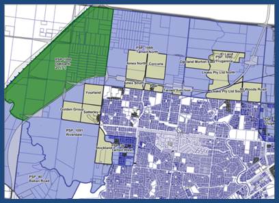
Leakes Road as a Key Priority
Leakes Road between Forsyth and Davis Roads (Plan 2) is considered to have the best potential to service these early Wyndham North development sites. It is also of strategic importance because of its location within the arterial road network.
For the large area between Hogans Road in the south and the proposed East-West bypass link to the north (in Melton), Leakes Road is the only arterial road providing a direct and relatively proximate freeway link – at the Kororoit Creek Road intersection with the Westgate Freeway.
Plan 2 – Draft Wyndham North DCP PIP for consultation (January 2016 version)
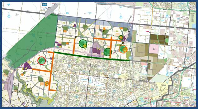
The relevant section of Leakes Road is shown in green on Plan 2. The DCP provides for its upgrade and duplication, at a total cost of nearly $90m.
The section of Leakes Road between Forsyth Road and the Federation Trail is financed by the Truganina Employment Precinct DCP. The remaining part, from the Federation Trail to the Westgate Freeway, is the responsibility of VicRoads. Construction of the Council portions will lend weight to Council’s advocacy position that VicRoads should commit to the early upgrade and duplication of its section.
DCP PIP Formulation
Estimation of DCP cash inflows beyond one or two financial years is very difficult due to cyclical variations in demand for new housing and more general economic uncertainty. However, early indications are that the Wyndham North DCP can generate sufficient funding for the upgrade and duplication of the relevant sections of Leakes Road between now and the end of the 2019/2020 financial year. These “green” projects therefore have the highest priority in the 2016/17 Wyndham North DCP PIP.
The progressive upgrade and duplication of Leakes Road in a westerly direction from Forsyth Road will provide an axis from which other key items of road infrastructure can subsequently be constructed, to the benefit of the new and future residents of Wyndham North. They comprise sections of Morris, Dohertys, Tarneit, Sayers and Davis Roads (shown in orange in Plan 2), some of which could be constructed between 2020/21 and 2024/25. These “orange” projects have the next highest priority for financing and construction.
Desired Outcomes from Wyndham North DCP PIP
· Delivery of the majority of Leakes Road (including all bridges, culverts and intersections) as a spine for the development of Wyndham North.
· Consideration of other roads that support this spine or grow directly from it.
· Prioritising recreation and community infrastructure that aligns with the current and expected development pattern.
· In-kind transfer of land, at DCP values, when offered by owners unless it is unfeasible from a financial or planning perspective.
Landowner / Developer Consultation – January to March 2016
Landowners and developers were briefed on 18 January 2016, with submissions being invited between January and mid-March 2016. Despite extensive consultation, a number of developers were unaware of the DCP PIP because they are not the underlying landowner. These developers have now been made aware of the DCP PIP process and a number have made submissions. A total of 16 submissions were ultimately received.
The following principal issues were raised in the submissions received, a Council officer response has also been provided:
· Alignment of priority DCP projects with existing growth fronts;
o The recommended Wyndham North DCP PIP 2016/17 does its best to align the prioritisations of DCP projects with existing growth fronts while managing competing infrastructure demands.
· Due to the large area covered by the DCP, the DCP PIP should contemplate local catchment areas.
o The DCP PIP is for the whole of the DCP area, this facilitates the capacity to fund infrastructure that will benefit the entire DCP area. Local catchments are also considered in terms of ensuring a level of basic infrastructure serviceability is available in a timely manner to each PSP area within the DCP.
· Traffic analysis showing that Leakes Road west of Derrimut Road is not needed in the first four (4) years.
o The recommended Wyndham North DCP PIP 2016/17 supports the reallocation of the duplication of Leakes Road west of Tarneit Road from years 1 to 4 to years 5 to 10 while continuing to pursue land acquisition and design work in the first four years for the Leakes Road land west of Tarneit Road.
· Council does not have the ability to acquire land for DCP projects in the period covered by the draft Wyndham North DCP PIP if development slows.
o Council has compulsory acquisition powers if required.
· Intersections are critical to initial access arrangements for estates and a proposal was made for an unallocated intersection facilitation fund to address this.
o The suggestion of an unallocated intersection facilitation fund is an interesting proposition and Council appreciates the intent behind it. However, Council needs to deliver infrastructure as funds become available. The setting aside of unallocated funds runs contrary to the need to deliver identified infrastructure priorities in a timely manner.
· A more detailed program is needed for the construction of Leakes Road;
o Council is currently preparing a more detailed program for the delivery of Leakes Road, when completed this will provide further and more detailed guidance on this matter that will be of benefit to all those involved in the delivery of Leakes Road, namely Council, VicRoads and the development community.
· The draft Wyndham North DCP PIP timeframes are too “coarse” for proper planning.
o The cash flow models that support the DCP PIP are based on estimated incoming cash flows and expenditures expected within a given financial year. Although the DCP PIP itself is structured around a short term 1-4 year timeframe that is designed to align with Council’s Capital Works Program (CWP), it will be implemented through Section 173 Agreements that will consider the availability of funds within any given single financial year. These agreements will need to consider both the capacity of the DCP PIP to fund the specific project both within that financial year and the longer CWP timeframe (i.e. what impact would bringing a project forward have on the capacity to deliver all other projects listed in the DCP PIP “green” 1-4 year timeframe). It may be that a “green” project won’t be funded in year 1, but it may be funded in either year 1, 2, 3 or 4 and this detailed decision making will occur at the Section 173 Agreement stage of the process. Clearly not all “green” projects need to be delivered in year 1. Some will need to be delivered in years 2, 3 and 4.
· Developers expecting immediate or early credits for DCP works-in-kind (WIK), irrespective of Council’s requirements to manage cash flows.
o The Wyndham North DCP clearly articulates that WIK projects and credits must be agreed with Council. To assume that infrastructure items would be credited without first confirming this with Council and seeking agreement via Section 173 Agreement as outlined in the DCP is ill advised. Council will be reiterating and making it clear, although arguably it has been clear since the DCP was gazetted, that only agreements entered into under Section 173 of the Planning and Environment Act will be used to confirm arrangements relating to WIK credits. Proponents should not assume that such credits will be forthcoming until an agreement under Section 173 of the Planning and Environment Act has been reached. As discussed during the presentation to the development community in January, Council does not have the financial resources to facilitate every WIK request that may be proposed without putting itself under considerable financial burden.
· Prioritisation of Leakes Road east of Derrimut Road will stall development in the Riverdale PSP area.
o The recommended Wyndham North DCP PIP 2016/17 supports the reallocation of the duplication of Leakes Road west of Tarneit Road from years 1 to 4 to years 5 to 10 while continuing to pursue land acquisition and design work in the first 4 years for the Leakes Road land west of Tarneit Road.
· Inequitable distribution of DCP funds to priority projects: All of the priority projects are located in, and will benefit, the Tarneit North and Truganina PSP areas. Under the draft Wyndham North DCP PIP, Council would be redirecting funds collected from the Riverdale PSP area to landowners and developers in Tarneit North and Truganina, to fund DCP infrastructure that disproportionately benefits those two areas.
o The prioritisation of infrastructure delivery is completely consistent with the principles underlying the development contributions system in Victoria, namely the principles of need, nexus, equity and accountability. Prioritisation clearly responds to an identified need, the DCP PIP has nexus to the DCP because the prioritised projects are identified by the DCP and it is equitable because all those developing land are contributing towards the prioritised projects. Further, the DCP itself was prepared in accordance with the principles underlying the development contributions system in Victoria and the DCP clearly contemplates a DCP PIP and the prioritisation of infrastructure delivery.
o Noting all of the above, it has been accepted following consideration of submissions, that there is merit in redistributing some of the priorities identified in the draft Wyndham North DCP PIP so that all development fronts are being adequately serviced with appropriate levels of infrastructure provision. To this end, there are now more “green” year 1-4 projects with the potential to service the Riverdale PSP area shown on the recommended Wyndham North DCP PIP 2016/17.
· Practical delivery of DCP infrastructure: It is considered that the full delivery of the duplication of Leakes Road within the next five (5) years is not only optimistic, but unachievable.
o It has been recommended in the Wyndham North DCP PIP 2016/17 to push out the time frame of delivery for the western most section of Leakes Road, west of Tarneit Road, therefore reducing the scope of works that need to be delivered within the first 4 years. This has been done because the need for the duplication of this western portion of Leakes Road in terms of traffic volumes is not yet at sufficient levels to warrant its construction.
· The draft Wyndham North DCP PIP should provide for the redirection of surplus DCP funds where priority projects have been substantially delayed or not delivered.
o The proposed annual review process for the DCP PIP will enable the identification of delayed or non-delivered projects, however, it is anticipated that all funds collected will need to be spent and in a timely fashion to ensure an appropriate rollout of infrastructure. The DCP PIP also provides certainty on the Council side of the equation to facilitate early planning of project delivery.
· The draft Wyndham North DCP PIP should be a “living” document with regular updates and review to ensure that the assumptions underpinning the PIP remain valid. The PIP should identify this review mechanism.
o The Wyndham North DCP PIP is and will continue to be a “living” document. It is intended for the documentation to be reviewed annually on a financial year basis and it is intended for there to be a standard process for an annual review cycle for the DCP PIP.
Recommended Wyndham North DCP PIP 2016/17
The focus of the 2016/17 Wyndham North DCP PIP in the short term will be the delivery of Leakes Road including the Tarneit Road / Leakes Road intersection and the duplication of Leakes Road east of this intersection to Forsyth Road. The 2016/17 Wyndham North DCP PIP also focuses on a number of other critical intersections that will facilitate access to future Council infrastructure and key community facility and active open space projects that will be required to respond to this growing communities immediate needs.
Plan 3 – Recommended Wyndham North DCP PIP 2016/17
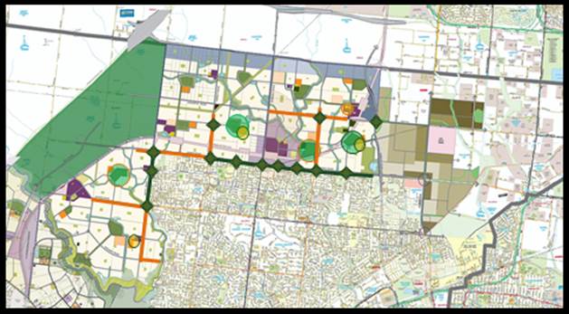
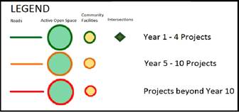
Note: Projects beyond Year 10 not shown.
3. City Plan/QCP
2.2 City Infrastructure - To deliver and maintain Wyndham's facilities and infrastructure in an efficient and equitable manner that meets community needs.
4. Financial Implications
The projects outlined above are classified as development infrastructure in the Wyndham North DCP and as such are notionally fully funded from development contributions collected under the DCP. The approach to estimating DCP cash inflows underpinning the 2016/17 Wyndham North DCP PIP is intended to facilitate timely infrastructure delivery while ensuring that Council does not have to draw on other funding sources during its implementation. This DCP PIP will also be integrated with Council’s Capital Works Program and Long Term Financial Plan.
5. Community Consultation
If projects are to be provided by Council and form part of the Capital Works Program, there will be community consultation as part of the normal budget process. Conversely, where Council agrees to contributions as land and/or works-in-kind, consultation is not required.
|
Strategic & Town Planning |
|
Ordinary Council Meeting Monday, 27 June 2016 |
|
File No: C197
|
|
Item No: 6.4.2 Director Sustainable Development - Dean Rochfort |
|
|
|
|
|
Planning Scheme Amendment C197 - Boundary Road Design Guidelines |
||
Amendment C197 seeks to introduce the Boundary Road Office and Industrial Precinct Design Guidelines as a reference document into the Wyndham Planning Scheme for land designated in the Truganina and Tarneit North Precinct Structure Plans as office and light industrial. The Guidelines have been prepared by SJB Urban and Planning in conjunction with Council.
At the Ordinary Council Meeting on 26 October 2015, Council resolved to adopt the Boundary Road Design Guidelines (2015) as a reference document subject to changes, prepare the amendment and seek authorisation from the Minister, and exhibit the amendment. The amendment was exhibited from 14 March to 18 April 2016.
Following the exhibition, a total of five (5) submissions were received. Submissions which sought a change or objected to the amendment have been reviewed. As not all the submissions can be resolved, it is recommended that the amendment be referred to an Independent Panel.
Attachments
|
1. |
Boundary Road Office and Industrial Precinct Design Guidelines - printed in separate document |
|
2. |
Schedule 11 - Design and Development Overlay - printed in separate document |
Officers’ Declaration of Interests
Under Section 80C of the Local Government Act 1989 (as amended), officers providing advice
to Council must disclose any interests, including the type of interest.
Director Sustainable Development - Dean Rochfort
In providing this advice as the Director, I have no disclosable interests in this report.
Manager Town Planning - Peter Van Til
In providing this advice as the Manager, I have no disclosable interests in this report.
Senior Planning Projects Officer - Maree Phillips
In providing this advice as the Author, I have no disclosable interests in this report.
Key Issues
· Amendment C197
· Changes to the Amendment as a result of submissions
· Referral of submissions to Panel
|
RECOMMENDATION
That Council resolves to: 1. Request the Minister for Planning to appoint an Independent Panel pursuant to Section 23(1)(b) of the Planning and Environment Act, 1987 to hear all submissions and consider proposed Amendment C197 to the Wyndham Planning Scheme.
2. Refer all submissions to the Panel appointed to consider proposed Amendment C197.
3. Submit to the Panel its response to the submissions generally outlined in this report and in the attached marked-up Boundary Road Design Guidelines 2015 and the Schedule 11 to the Design and Development Overlay.
4. Authorise Council officers to refine wording and the formatting of proposed Amendment C197 prior to the Panel Hearings.
|
|
CRS Glenn Goodfellow / Peter Maynard
That Council resolves to: 1. Request the Minister for Planning to appoint an Independent Panel pursuant to Section 23(1)(b) of the Planning and Environment Act, 1987 to hear all submissions and consider proposed Amendment C197 to the Wyndham Planning Scheme.
2. Refer all submissions to the Panel appointed to consider proposed Amendment C197.
3. Submit to the Panel its response to the submissions generally outlined in this report and in the attached marked-up Boundary Road Design Guidelines 2015 and the Schedule 11 to the Design and Development Overlay.
4. Authorise Council officers to refine wording and the formatting of proposed Amendment C197 prior to the Panel Hearings.
(CARRIED) |
1. Background
The amendment to introduce guidelines over land of approximately 284 hectares in area will provide the design criteria for industrial development projects to ensure the precinct develops into an attractive and functional office and light industrial area. The Guidelines are the reference document to the Schedule (DDO11).
The Tarneit North and Truganina Precinct Structure Plans have designated an area of office/light industrial land on Boundary Road, Truganina and Tarneit. The land has applied Industrial 3 and Commercial 2 Zoning and directly interfaces with proposed residentially zoned land.
The current land use is predominately farming. The site is bounded by Davis Road to the west, Boundary Road and the municipalities of Melton and Brimbank to the north, the Wyndham Industrial Estate to the east and future residential land to the south.
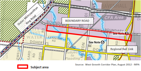
Council received authorisation to prepare Amendment C197 by the Minister for Planning on 28 January 2016. The Minister authorised the preparation of the amendment subject to the following conditions:
· The DDO mapping be modified so that it is only contained within the boundaries of the Tarneit North and Truganina Precinct Structure Plans.
· Formal comments must be sought from Vic Roads and the Metropolitan Planning Authority during exhibition.
· Ensure the application requirements within the proposed DDO11 do not duplicate the application requirements contained within the Commercial 2 Zone and Industrial 3 Zone within the Truganina Precinct Structure Plan and the applied Industrial 3 Zone within the Tarneit North Precinct Structure Plan.
Amendment C197 was amended and exhibited in accordance with the directions of the Minister for Planning and resulted in a total of five (5) submissions.
2. Discussion
Amendment C197
As reported in the Council agenda (item 6.4.1) at the meeting on 26 October 2015, Council has developed the guidelines in conjunction with SJB Urban and Planning to assist in the preparation of planning permit applications. The Guidelines also form the DDO which will be used in the assessment of the planning permit applications.
Amendment C197 will implement the controls in the Guidelines into the Wyndham Planning Scheme by:
· Amending the Local Planning Policy Framework to include the Guidelines as a reference document in Council’s Municipal Strategic Statement and specific objectives and strategies relating to the Boundary Road Precinct.
· Amending the mapping and introducing a new schedule to the Design and Development Overlay.
Changes to Amendment as a Result of Submissions
A review of the issues raised has resulted in some changes to the Schedule (DDO) and the Guidelines. Changes to be applied relate to the following:
· Enhanced acoustic protection for nearby residents;
· Loading and servicing siting clarified;
· Some setback variances, where appropriate;
· Permissible building heights increased to 9m from 6m along residential and creek interface;
· Canopy trees provided at a ratio of 1/6, amended from 1/4; and
· Clarified permit not required for directional signs.
A detailed assessment of submissions is shown in Section 10 of this report.
Road Interface Comments:
The inclusion of a road between office / industrial and residential land was a specific requirement of Council at the time the Design Guidelines were adopted. The amendment has required that the road interface be included as a mandatory requirement. However since this, the area has been the subject of further investigation in regard to the conceptual plans, as the connecter road shown may not be the ‘best fit’ in regard to the future residential subdivision layout to the south.
Height and Setback Variations:
The issues raised by the submitters seeking to reduce setbacks and increasing heights will be mainly dealt with at the planning permit stage. The flexibility / variances of setbacks, building heights and landscapes widths sought by the submitters are generally provided through the wording of the Schedule. The permit applicant can demonstrate that the proposal is suitable in accordance with the Guidelines.
As the submitter’s requests could not all be dealt with internally, Council is required to make a formal request to the Minister of Planning to appoint the Panel. Planning Panels Victoria will then confirm hearing dates upon receipt of Council’s request.
A copy of the proposed amendments to the Design Guidelines and the Design and Development Overlay are shown in the attachments.
Referral of Submissions to Panel
In accordance with the requirements of the Planning and Environment Act 1987, Council as the planning authority must consider all submissions. Section 23 of the Act states that when considering a submission it must:
(a) Change the amendment in the manner requested; or
(b) Refer the submission to a panel; or
(c) Abandon the amendment or part of the amendment.
Council officers have considered the submissions and where reasonable, or where there were inconsistences in the Guideline and Schedule, have recommended that changes be made.
As not all submissions can be resolved, it is recommended that the submissions be referred to Planning Panels Victoria for review.
The panel must consider all submissions referred to it and give all parties a reasonable opportunity to be heard. The panel will then report its findings to the planning authority and make any recommendation it thinks fit.
Once the panel’s report is received, the amendment will be reported back to an Ordinary Council Meeting to consider the report, and whether or not to adopt the amendment.
3. City Plan/QCP
2.3 Sustainable Growth - To ensure Wyndham's population growth is matched by the development of new physical, social and economic infrastructure, while protecting the City's existing assets and natural environment.
4. Council Policy
The changes the amendment proposes are supported by current policy in the following manner:
· The Guidelines have been undertaken to provide a reference document to support the Tarneit North and Truganina Precinct Structure Plans.
· The proposed amendment is consistent with relevant Local Planning Policy. In particular, it is supported by Clauses 21.08 and 21.02 of the Municipal Strategic Statement, which relates to Urban and Economic Growth.
5. Financial Implications
Provision of resources for the Amendment has been made in the Town Planning budget. Costs include fees associated with the Panel Hearing, Planning Scheme Amendment and expert evidence from a design consultant, if required.
The application of the Design and Development Overlay over the precinct will result in a requirement for planning consent for buildings and works, the application fees are paid by the developers.
Service roads will be required along arterial roads and will be funded by the developer, as set out in the Truganina and Tarneit North Precinct Structure Plans.
6. Social Implications
The social implications resulting from this Amendment are anticipated to have a positive benefit for the Wyndham community. The design guidelines, once approved by the Minister will provide the direction to developers to ensure the built form will enhance this important gateway site.
7. Environmental Implications
Previous plans and strategies have addressed any natural environmental impacts. The Guidelines together with the Schedule will provide the reference and instrument to ensure the future built environment respects the existing natural environment, importantly the creek corridors, through setbacks, landscaping, orientation and screening.
8. Economic/Employment Considerations
Economic benefit will be achieved through the use of the land for commercial and light industry. The building industry will benefit during the construction phase and long term employment opportunities will be generated, which in turn have a positive flow on effect to existing business and communities.
9. Options
Should Council decide not to refer the submissions to a Panel, the amendment must be abandoned. The Minister for Planning would be notified accordingly.
Should this option be pursued it is worth noting that Council’s adopted Design Guidelines would have no status in the Wyndham Planning Scheme and limited statutory weight in assessing future planning permit applications.
10. Community Consultation
The amendment was prepared and exhibited in accordance with the conditions of authorisation of the Minister for Planning, and as a result of the exhibition, five (5) submissions have been received.
The following table is an overview of submitters and the issues raised:
|
|
Issues and/or comments |
Recommendation |
|
1 |
Generally satisfied, request to minor changes to both the Guidelines and the Schedule regarding acoustic amenity, residential interfaces and loading. |
Changes supported as they enhance the requirements for residential amenity. |
|
2 |
Generally unsatisfied as amenity of residential interface takes priority over the design and development of future development. · Request changes to setbacks along Boundary Road / major road frontages, collector roads and side setbacks. Landscaping setbacks are onerous. · Minor changes to car parking and loading guidelines. · Requested deletion of the guideline which states Melbourne Water and Council should clearly establish and communicate plans for creek corridors on public land, including for landscape treatments and shared paths. Reason - Statement not a guideline. · Insert the words ‘if required’ to Guideline C11 Acoustic protection. · Requested amendment to Building heights in C19 Guideline and inclusion of statement to clarify that architectural features and plant can exceed the height limits imposed. · Front fence heights should be 1.8m not 1.5m. · Tree planting guidelines (E23) should be deleted as there is sufficient landscaping within the front setback. · E24 change definition of large car park to 30 spaces, currently states 20 spaces. · Onerous to require a planning permit for advertising signs. |
· No change. Building and landscaping setbacks to remain as previously adopted. · No change to car parking and loading as current wording provides flexibility. Loading and servicing should generally be located away/out of view from street or creek/public realm frontages. · No change. Both the Tarneit North PSP and the Truganina PSP require Melbourne Water and Council to work co-operatively around development near a natural waterway. · No change as current wording provides the flexibility sought by the submitter. · Change building heights from 6m to 9m for residential and creek interfaces Include ‘Architectural features and plant can exceed the height limits above’. · No change to front fence heights as consistent with PSPs. · No change to tree planting guidelines, remain as adopted. |
|
3 |
The retention and demolition of dry stone walls should have regard to the Wyndham Dry Stone Walls Study, Heritage Overlay and relevant Precinct Structure Plans. All other comments are duplicated in the submission from Submission #2. |
Noted |
|
4 |
The Guidelines are not written in a form that is suitable for implementation via the Wyndham Planning Scheme. · Reword Schedule in regard to car parking as it is unreasonable to expect every site to have car parking at side or rear. · Unclear why the zero setback for Tarneit Road given that Council is seeking a smaller lot configuration in this area. · A 6m building height along residential and creek interface unnecessarily restrictive. · Landscaping setback at residential interface should be changed to 3m from 6m. · Minor utility and servicing infrastructure normally at front of allotments and Schedule should recognise this. · Requires clarification of the meaning of “infrastructure design” and also definition of “active interface”. · Acoustic report only required when in the opinion of the responsible authority the proposed use has the potential to generate significant noise. · The requirement for a SDA and Management Plan is indiscriminate and fails to define what constitutes either a SDA or management plan. · Wyndham City Council does not have an ESD policy, therefore, no guidance in relation to the objective, requirements or design guidelines. · Requires clarification of the requirement for the future provisions of a service lane. |
· No change. Some car parking at frontages permitted where practical, such as visitors accessing the front entrance. · No change as this area is part of the town centre interface and as such will have a direct relationship with the future town centre as identified within the PSP. The site will have a finer development scale complimenting the zero setback. · No change to the requirement for an Acoustic Report as current wording states ‘where appropriate’. · The inclusion of a Sustainable Design Assessment (SDA) and Management Plan at the planning assessment stage (if required) will provide efficient and sustainable environmental design outcomes. · The requirement to provide for future service lanes will assist in mitigating impacts of increased traffic volumes generated by new development. |
|
5 |
Generally satisfied, although concern that the references to restricted retail will encourage out-of-centre development that would impact on other activity centre. |
Note that the Precinct Structure Plans specifically allow this use and the Design Guidelines simply seek to be consistent with the PSPs.
Agreed to include discussion in the “How to use..” section of the Guidelines to emphasise use and development will still need to comply with other strategic documents, such as the PSP, Activity Centre Strategies, etc. |
|
Strategic & Town Planning |
|
Ordinary Council Meeting Monday, 27 June 2016 |
|
File No: WYP8078/14
|
|
Item No: 6.4.3 Director Sustainable Development - Dean Rochfort |
|
|
|
|
|
Planning Permit Application WYP8078/14 - Amendment for VCAT - 500 Purchas Street - Residential Subdivision |
||
At the Ordinary Council Meeting on 14 December 2015, Council resolved to refuse Planning Permit Application WYP8078/14 for the Residential Subdivision (49 lots) and Removal of Easement at No.500 Purchas Street, Werribee. A summary of the grounds of refusal included, inconsistency with objectives and strategies contained within the State Planning Policy Framework, local planning policies including the Municipal Strategic Statement, impractical outcome of the partial removal of a community asset to facilitate the construction of a road, unsympathetic response to the heritage values of the adjoining heritage place, impact on the historic value of existing vegetation across the site and the layout would not make a positive contribution to the amenity of the surrounding area.
Subsequently, the applicant appealed Council’s decision and is subject to a Tribunal Hearing on 6 July 2016. On 18 May 2016, the applicant lodged a Notice of an Amendment of an Application with the Tribunal seeking to substitute the amended plan for those originally submitted with the Permit Application. The applicant circulated the amended plan to all parties to the hearing. The changes to the plan include:-
· a reduction in the number of lots from 49 to 41;
· an increase in lot sizes fronting the Werribee River;
· fewer lots less than 500sq.m;
· removal of the road connection between each parcel of land with the configuration of the Council reserve remaining unchanged;
· new access to Heaths Road for the larger parcel of land; and
· alteration to road/court widths.
An assessment of the proposal has been undertaken of the amended plan submitted with the application to the Tribunal. The amended plan has been considered against the relevant provisions of the Wyndham Planning Scheme and Council’s original Grounds of Refusal. It is considered that the amended plan does not satisfactorily address Council’s original grounds of refusal and is considered to be inappropriate.
This report recommends that Council refuse to support Amended Plan (Version 10) prepared by Carson Simpson Ltd dated 17 May 2016 for Residential Subdivision (41 lots) and Removal of Easement at No.500 Purchas Street, Werribee.
Attachments
|
1. |
Subject Site - Location of Existing Vegetation & Existing Powerline Easement - printed in separate document |
|
2. |
Original Subdivision Layout - 500 Purchas Street, Werribee - Subdivision Layout (Ver 4 considered at OCM 14-12-2015) - printed in separate document |
|
3. |
Substituted Amended Plan for VCAT - 500 Purchas Street, Werribee - Amended Subdivision Layout (Ver 10 - Current Plan) - printed in separate document |
Officers’ Declaration of Interests
Under Section 80C of the Local Government Act 1989 (as amended), officers providing advice to Council must disclose any interests, including the type of interest.
Director Sustainable Development - Dean Rochfort
In providing this advice as the Director, I have no disclosable interests in this report.
Manager Town Planning - Peter Van Til
In providing this advice as the Manager, I have no disclosable interests in this report.
Senior Town Planner - Danielle Kearney
In providing this advice as the Author, I have no disclosable interests in this report.
Key Issues
· Substituted Amended Plan for VCAT
· Response to the previous Grounds of Refusal
|
RECOMMENDATION
That Council would have resolved to issue a Refusal to Grant a Planning Permit for Residential Subdivision (41 lots) and Removal of Easement at No.500 Purchas Street, Werribee on the basis that: 1. The amended plan fails to satisfactorily respond to the Council’s original Grounds of Refusal with respect to: a) The proposal is inconsistent with the relevant sections of the State Planning Policy Framework, local planning policies including the Municipal Strategic Statement in that it is contrary to the objectives and strategies of Clause 21.01 (Municipality Profile), Clause 21.02 (Settlement), Clause 21.03 (Environment and Landscape Values), Clause 21.04 (Environmental Risks), Clause 21.05-2 (Waterways) and Clause 21.06 (Built Environment and Heritage). b) The proposal is not sympathetic or responsive to the heritage values of the adjoining heritage place. c) The proposal would have a detrimental impact on the historic/heritage value of the existing vegetation across the site. d) The proposal would not make a positive contribution to the amenity of the area. 2. The amended plan requires fundamental changes with regard to Council’s Engineering requirements in terms of access, street layout and design, provision of on-street car parking, road widths and access to the Council Reserve.
|
|
CRS John Gibbons / Gautam Gupta
That Council would have resolved to issue a Refusal to Grant a Planning Permit for Residential Subdivision (41 lots) and Removal of Easement at No.500 Purchas Street, Werribee on the basis that: 1. The amended plan fails to satisfactorily respond to the Council’s original Grounds of Refusal with respect to: a) The proposal is inconsistent with the relevant sections of the State Planning Policy Framework, local planning policies including the Municipal Strategic Statement in that it is contrary to the objectives and strategies of Clause 21.01 (Municipality Profile), Clause 21.02 (Settlement), Clause 21.03 (Environment and Landscape Values), Clause 21.04 (Environmental Risks), Clause 21.05-2 (Waterways) and Clause 21.06 (Built Environment and Heritage). b) The proposal is not sympathetic or responsive to the heritage values of the adjoining heritage place. c) The proposal would have a detrimental impact on the historic/heritage value of the existing vegetation across the site. d) The proposal would not make a positive contribution to the amenity of the area. 2. The amended plan requires fundamental changes with regard to Council’s Engineering requirements in terms of access, street layout and design, provision of on-street car parking, road widths and access to the Council Reserve.
(CARRIED) |
1. Background
Subject Site and Surrounds
The subject site is located at 500 Purchas Street, Werribee and is known as Lot 3 on Plan of Subdivision 340970.
The site is an irregular shaped lot comprising of two separate parcels of land with a total area of 3.5ha. The two parcels of land are separated by a reserve that is vested in Wyndham City Council for Municipal Purposes. Entrance to the reserve is via Heaths Road, a declared road.
This reserve contains a gravel driveway that includes a circular gravel area used for informal vehicular parking. The reserve also provides pedestrian connection to the Riverbend Historic Park and Werribee River corridor, a well vegetated natural environment situated between existing urban and rural environments. The corridor adjacent to the site includes a picnic area, walking trails and canoe launch area. The diversion weir is located slightly west along the river.
The subject site has frontage to Heaths Road and backs onto the Werribee River corridor. The site generally slopes south towards the Werribee River and water supply irrigation channel. The site is vacant and is affected by a 10 metre wide electricity easement that traverses both parcels of land, including the Council reserve.
There are 31 trees across the site. A stand of Sugar Gum trees approximately 100m in length containing 18 trees is located on the larger parcel of land. The trees are angled across the site near the Heaths Road frontage. The remaining trees scattered across the site are Peppercorn trees, with the exception of a single Grevillea. A row of Peppercorn trees is located near the roundabout where Purchas Street intersects Heaths Road.
Surrounding Area
The subject site forms part of an established residential area and is the last remaining undeveloped parcel of land of this scale in the area to be subdivided into residential lots.
Land to the north and west of the site is defined by the Werribee River and Riverbend Historic Park.
North of the site, on the eastern side of the river is established residential development. This area was subdivided in the mid 1990’s with lot sizes ranging between 750sq.m to 1100sq.m. Dwelling types predominantly consist of large double storey dwellings with well- established front landscaped setbacks. This residential development fronts the Werribee River and is accessed from River Park Drive.
East of the site contains residential development which backs onto Heaths Road with access available from Purchas Street. This area was subdivided in the mid 1980’s with lot sizes ranging from 540sq.m to 630sq.m.
Land to the south of the site contains residential development that consists of larger lots compared to the subdivision to the north and east. The subdivision to the south and the subject site are separated by the Southern Rural Water Irrigation Channel. This subdivision was also developed in the mid 1980’s with the lots closest to the irrigation channel greater than 2400sq.m. The two lots closest to Heaths Road are examples of further residential subdivision within this estate. This type of small scale subdivision is limited with lots being predominately large containing single dwellings.
Land situated on the northern side of the Werribee River is used for market gardening purposes.
In terms of the wider context, the site is:
• 2km to Werribee Town Centre;
• 3km to Werribee Plaza;
• 1.3km to Wyndham Village Shopping Centre;
• 1km – 2km to Primary and Secondary Schools; including Westgrove Primary and Galvin Park Secondary College;
• 1km to the Maternal & Child Health Centre and Quantin Binnah Community Centre;
• 500m to Galvin Park Recreation Reserve;
• 1km to Presidents Park;
• Direct abuttal to Riverbend Historic Park and Werribee River; and
• 220m to a bus stop on Heaths Road (south of the Italian Social Club).
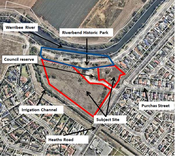
Location of Subject Site and immediate Surrounds
2. Discussion
Proposal
The original subdivision application consisted of 49 lots and removal of electricity easement with a single access point into the subdivision from the roundabout at Purchas Street/Heaths Road. The proposed internal road network resulted in the Council reserve being split into two sections.
The amended plan submitted to the Tribunal has resulted in a revised layout that removes the previously proposed road connection across the Council reserve. The Council reserve will remain an entire parcel of land with subdivision proposed on either side of the reserve.
A summary of the differences between the original plan and amended plan is detailed in the table below:
|
Aspects of the Proposal |
Original Subdivision Layout |
Amended Subdivision Layout |
Difference/Comment |
|
No. of lots |
49 Lots |
41 Lots |
Decrease in lot number by 8 lots. |
|
Road connection across Council Reserve |
Internal road network intersects Council reserve, separating reserve into two sections. |
No internal road network to impact on the Council reserve |
Council reserve remains unchanged. |
|
Access to the Site |
Single access point from the roundabout at Purchas Street / Heaths Road. |
Three access points proposed with the original access point from the roundabout at Purchas Street / Heaths Road retained.
A 10 metre wide ingress adjoining the existing entrance to the Council reserve and a 10 metre wide egress further south is proposed creating a one-way in/out arrangement. |
Increase in number of access points to Heaths Road from one to three access points. |
|
Access to Heaths Road |
No direct access from a residential lot to Heaths Road. |
No direct access from a residential lot to Heaths Road. |
Plan layout remains unchanged. |
|
Access to River Park Court |
No direct access to River Park Court from the subdivision. |
No direct access to River Park Court from the subdivision. |
Plan layout remains unchanged. |
|
Tree Reserve along Heaths Road to prevent vehicular access |
2 metre Tree Reserve |
2 metre Tree Reserve |
Width of Tree Reserve remains unchanged. |
|
Drainage Reserve |
5 metre Drainage Reserve to the west of the court bowls |
5 metre Drainage Reserve to the west of the court bowl/internal road network. |
Minor change to the plan in that the Drainage Reserve terminates at proposed lot 8. |
|
Vegetation Removal |
Removal of all vegetation across the site. |
Removal of all vegetation across the site. |
Proposal remains unchanged. |
|
Fencing Treatments for lots facing the Council Reserve |
1.6m fence providing slatted fencing that is 25 – 30% transparent. |
No details provided. |
Fencing treatments as per the original plan would be required. |
|
Fencing Treatments for lots backing onto Heaths Road |
Post & wire fencing |
Post & wire fencing |
Plan remains unchanged. Appropriate fencing treatments to Heaths Road would be required upon any approval. |
|
Power line Easement |
Removal of power line easement across the site. |
Removal of power line easement across the site. |
Plan remains unchanged. |
|
Court bowls |
Four (4) court bowls |
Four (4) court bowls |
The layout has been redesigned with a short court bowl provided on the smaller parcel of land.
The larger parcel of land incorporates three courts with an internal road network that provides ingress/egress to Heaths Road. The original layout incorporated four court bowls within the larger parcel of land with no direct access to Heaths Road. |
|
Footpaths within the subdivision |
Footpaths along one side of each road. |
Footpaths along one side of each road, except for the 16m wide north/south road within the larger parcel of land which provides footpaths on either side of the road. |
Only difference is a footpath on either side of the 16m wide north/south road within the larger parcel of land. |
A breakdown in the difference of the number of lots and lot range between both plans is provided in the following table:-
|
Original Subdivision Layout (Version 4) |
Amended Subdivision Layout (Plan for VCAT Version 10) |
|
||
|
Lot Size |
Number of Lots |
Lot Size |
Number of Lots |
Lot Difference |
|
400sq.m – 499sq.m |
36 |
400sq.m – 499sq.m |
16 |
-20 |
|
500sq.m – 599sq.m |
11 |
500sq.m – 599sq.m |
11 |
0 |
|
600sq.m - 699sq.m |
1 |
600sq.m - 699sq.m |
1 |
0 |
|
700sq.m+ |
1 |
700sq.m+ |
13 |
+12 |
|
Total |
49 |
Total |
41 |
-8 |
The original layout proposed 73% of lots ranging between 400sq.m to 499sq.m, whereas the amended plan proposes 39% of lots within this range and 31% of all lots being greater than 700sq.m.
Planning Scheme Controls
The subject land is zoned General Residential Zone under the Scheme. No overlay controls apply to the site. The purpose of the zone (in part) is to:-
· To encourage development that respects the neighbourhood character of the area.
· To implement neighbourhood character policy and adopted neighbourhood character guidelines.
· To provide a diversity of housing types and moderate housing growth in locations offering good access to services and transport.
Pursuant to Clause 32.08-2 (General Residential Zone), a permit is required to subdivide land.
An application to subdivide land, other than an application to subdivide land into lots each containing an existing dwelling or car parking space, must meet the requirements of Clause 56 and:
· Must meet all the objectives included in the clauses specified in the following table.
· Should meet all of the standards included in the clauses specified in the following table.
|
Class of Subdivision |
Objectives and Standards to be met |
|
16 – 59 lots |
All except Clauses 56.03-1 to 56.03-3, 56.03-5, 56.06-1 and 56.06-3. |
Pursuant to Clause 52.02 (Easements, Restrictions and Reserves), a planning permit is required to remove an easement. Before deciding on the application, the responsible authority must consider the interests of affected people. The application was referred to Powercor Australia for comment.
Planning Policy Framework
State Planning Policy Framework (SPPF)
The following policies in the SPPF are of particular relevance to the proposal:
Clause 11 (Settlement)
Planning is to anticipate and respond to the needs of existing and future communities by providing adequately zoned and serviced land for housing, employment, recreation and open space, community and commercial facilities and infrastructure.
Clause 11.02-1 (Supply of Urban Land)
Objectives of Clause 11.02-1 include:
· To ensure a sufficient supply of land is available for residential, commercial, retail, industrial, recreational, institutional and other community uses.
· Ensure the ongoing provision of land and supporting infrastructure to support sustainable urban development.
Clause 11.03-1 (Open Space Planning)
Clause 11.03-1 seeks to assist creation of a diverse and integrated network of public open space commensurate with the needs of the community. Under Clause 11.03, key strategies pertaining to new subdivisions should:
· Ensure that open space networks:
o Are linked through the provision of walking and cycle trails and rights of way.
o Are integrated with open space from abutting subdivisions.
o Incorporate, where possible, links between major parks and activity areas, along waterways and natural drainage corridors, connecting places of natural and cultural interest, as well as maintaining public accessibility on public land immediately adjoining waterways and coasts.
· Ensure that land is set aside and developed in residential areas for local recreational use and to create pedestrian and bicycle links to commercial and community facilities.
Clause 15.01-3 (Neighbourhood and Subdivision Design)
Clause 15.01-3 seeks to ensure the design of subdivisions achieves attractive, liveable, walkable, cyclable, diverse and sustainable neighbourhoods. Strategies include - in the development of new residential areas and in the redevelopment of existing areas, subdivision should be designed to create liveable and sustainable communities by:
· Contributing to an urban structure where networks of neighbourhoods are clustered to support larger activity centres on the regional public transport network.
· Creating compact neighbourhoods that have walkable distances between activities and where neighbourhood centres provide access to services and facilities to meet day to day needs.
· Creating a range of open spaces to meet a variety of needs with links to open space networks and regional parks where possible.
· Providing a range of lot sizes to suit a variety of dwelling and household types to meet the needs and aspirations of different groups of people.
· Contributing to reducing car dependence by allowing for:
o Subdivision layouts that allow easy movement within and between neighbourhoods.
o A convenient and safe road network.
o Creating a strong sense of place because neighbourhood development emphasises existing cultural heritage values, well designed and attractive built form, and landscape character.
o Protecting and enhancing native habitat.
Clause 16 (Housing) states that:
· Planning should provide for housing diversity, and ensure the efficient provision of supporting infrastructure.
· New housing should have access to services and be planned for long term sustainability, including walkability to activity centres, public transport, schools and open space.
· Planning for housing should include providing land for affordable housing.
Clause 16.01-4 (Housing Diversity)
Objectives of 16.01-4 include providing for a range of housing types to meet increasingly diverse needs, and encouraging the development of well-designed medium-density housing which:
· Respects the neighbourhood character.
· Improves housing choice.
· Makes better use of existing infrastructure.
· Improves energy efficiency of housing.
Local Planning Policy Framework (including MSS)
The local planning policies that are most relevant to the proposal are:
Clause 21.01-1 Municipal Profile
Wyndham is one of metropolitan Melbourne’s designated growth corridors. Characteristics of the Wyndham community include a relatively high proportion of family households; a high birth rate; a larger average household size than metropolitan Melbourne; growing levels of cultural diversity; a relatively low level of socio-economic disadvantage; relatively lower levels of educational attainment; and growing levels of unaffordable housing.
Clause 21.01-3 Key Planning Issues
The key planning issues that are identified in the SPPF which Council needs to address in the future include: Settlement, Natural Environment and Landscape, Natural Resource Management, Housing, Economic Development, Infrastructure and Transport.
Clause 21.01-4 Strategic Vision
Council is committed to a plan of action designed to address priorities under five strategic themes: People, Place, Services, Environment and Organisational excellence. The Community Health, Wellbeing and Safety Plan (2013-2017) is one of Council’s key plans dealing with issues that impact on health and wellbeing of the community.
Clause 21.01-5 Strategic Framework Plan
Council has prepared a Strategic Framework Plan which identifies the major strategic directions for the municipality.
Clause 21.02 Settlement
Key issues
· Managing significant population growth.
· Developing infrastructure in partnership with State and Federal Governments.
· Protecting industrial and residential activities from encroaching on each other.
· Providing jobs closer to where people live especially in the new employment corridor.
Objective 1: To identify areas suitable for urban growth and development.
Strategies:
1.1 Concentrate most higher density residential and mixed use development and higher density employment areas and services within 400-800 metres of existing and planned rail stations.
1.3 Ensure that interfaces between residential and employment areas; between urban and rural areas; and between urban and industrial areas are planned to minimise land use conflicts.
1.4 Identify areas of constrained land that are not expected to be able to be developed over the life of the corridor plan.
Objective 2: To achieve cost effective and orderly management of urban growth.
Strategies:
2.1 Ensure that residential growth aligns with the delivery of key infrastructure items and the delivery of economic and employment growth.
2.2 Provide for growth on a scale and form consistent with maintaining the containment, compactness, accessibility and affordability of key growth areas.
2.3 Provide for new development to occur in areas that are not isolated from the core urban area and which integrate well with existing communities and infrastructure.
2.4 Support new development in areas where sufficient infrastructure can be provided.
Objective 6: To encourage safety, health, mobility, accessibility and a sense of place in design and development.
Strategies:
6.1 Ensure new residential development is integrated with public transport and is connected to walking and cycling links.
6.2 Improve connectivity and access around the city for all members of the community.
6.3 Create opportunities for people to connect through the creation of urban parks, pedestrian plazas and urban links.
Objective 7: To ensure that Wyndham is a city in which people feel confident to move freely and safely.
Strategies:
7.1 Ensure that issues of community safety and crime prevention are adequately considered.
7.2 Ensure that the integration of safety and security concerns are considered throughout the development assessment process.
7.3 Ensure that the design of infrastructure and neighbourhoods takes into account safety design principles.
Clause 21.02-1 Urban Growth
Objective 1: To identify areas suitable for urban growth and development.
Strategies:
1.1 Concentrate most higher density residential and mixed use development and higher density employment areas and services within 400-800 metres of existing and planned rail stations.
1.3 Ensure that residential growth aligns with the delivery of key infrastructure items and the delivery of economic and employment growth.
Objective 2: To achieve cost effective and orderly management of urban growth.
Strategies:
2.1 Ensure that residential growth aligns with the delivery of key infrastructure items and the delivery of economic and employment growth.
2.2 Provide for growth on a scale and form consistent with maintaining the containment, compactness, accessibility and affordability of key growth areas.
2.3 Provide for new development to occur in areas that are not isolated from the core urban area and which integrate well with existing communities and infrastructure.
2.4 Support new development in areas where sufficient infrastructure can be provided.
Clause 21.03 Environmental and Landscape Values
Clause 21.03-2: Significant environments and landscapes.
Key Issues: Protecting and enhancing the distinctive sense of place, cultural identity and landscape within the growth areas of Wyndham.
Objective 3: To safeguard the visual, natural and cultural heritage values of urban and rural landscapes.
Strategies
3.1 Identify areas of high biodiversity or landscape value that should be protected from development in accordance with Map 4 (Special Places and Landscapes Map).
3.2 Ensure that development plans and structure plans protect and enhance the key landscape features of Wyndham.
3.3 Acknowledge the key landscape characteristics of Wyndham in the early stages of planning for urban growth.
Clause 21.04 Environmental Risks
Objective 1: To encourage environmentally sustainable land use and development.
Strategies:
1.1 Promote low energy travel modes, such as walking and cycling.
1.2 Encourage higher urban densities in appropriate locations near public transport and activity centres to help shorten travel distances.
1.3 Ensure that housing and other buildings are energy and water efficient.
1.4 Ensure that the impacts from new development on rooftop solar energy collectors are minimised by lot orientation and building design.
1.5 Encourage storm water capture, recycled water and other means to reduce urban water demands.
Objective 2: To reduce the effects of climate change.
Strategies:
a. Evaluate proposals with a view to limiting their potential greenhouse effect.
Objective 3: To promote the use of water sensitive urban design (WSUD), including stormwater re-use.
Strategies:
3.1 Promote greater use of water harvesting and water reuse within residential areas.
3.2 Ensure all commercial, industrial and residential developments incorporate Water Sensitive Urban Design techniques particularly into their landscaped areas.
Objective 7: To minimise the impacts of heat island through urban design responses.
Strategies:
7.4 Encourage the use of materials and finishes to buildings and pavements that minimise heat island effects.
Clause 21.05-2 Waterways
Key Issues
Ensuring that urban development addresses waterways and open space corridors.
· Promoting waterways as significant environmental features.
· Improving the interface between waterways and development.
Objective 3
To protect waterways, aquatic areas, floodplains, wetlands, swamps and catchments.
Strategies
3.1 Protect, enhance and reinstate environmental values of the waterway.
3.2 Ensure that development minimises loss or damage to waterway values.
3.3 Incorporate best practice stormwater management in subdivision and drainage design.
3.4 Avoid increases in the rate of stormwater discharge.
3.5 Encourage connectivity of waterways to open space and other natural environment and landscape features.
Objective 4
To protect riparian land, vegetation communities, waterway valleys and escarpments.
Strategies
4.1 Protect and enhance waterway corridors and their view-sheds through use of good urban design, appropriate built form, water sensitive urban design, appropriate plantings and land management.
4.2 Protect and restore native vegetation corridors along waterways.
4.3 Establish an appropriate buffer to protect the environmental values of a waterway corridor from negative impacts of development.
4.4 Encourage passive open space provision and linkages along or within waterways corridors.
4.5 Encourage active open space along waterway corridors. .
4.6 Discourage new urban development or rural activity in any environmental protection buffer.
4.7 Ensure that if an environmental buffer is required to protect waterways, that it be transferred to Council.
4.8 Encourage development within viewsheds to protect views and avoid visual intrusion.
4.9 Require archaeological assessments prior to development for areas of identified significance and within 200 metres of watercourses.
4.10 Encourage the existing natural features of waterways to be retained in preference to constructed waterways.
4.11 Incorporate protection and management recommendations in PSPs and planning permit conditions.
Clause 21.06 Urban Environment
Key Issues
Improving the presentation of urban areas and entrances, particularly from major roads, gateways and waterways.
Objective 1: Improving the design, siting and landscaping of development.
Strategies:
1.1 Ensure that urban design and landscaping is addressed in managing the visual amenity of gateways, transport routes, the coast, waterways, streets and places.
1.2 Ensure that multi-unit housing is well landscaped, with tree and shrub selection creating a positive visual image.
1.3 Ensure there is adequate scope for canopy tree planting in private properties and within street reservations.
1.8 Ensure that high quality urban design outcomes are achieved for lots with rear access.
Clause 21.07-1 Residential development
Objective 1: To provide variety and choice in housing densities.
Strategies:
1.4 Encourage medium density housing, especially within close walking distance of existing and planned fixed rail stations, defined Activity Centres and bus routes.
Objective 2: To provide a diversity of choice in housing styles and designs.
Strategies
2.1 Encourage housing that meets a diversity of community needs incorporating a ‘universal’ dwelling design.
2.2 Support housing and accommodation for the ageing population.
2.3 Encourage the provision of an adequate supply of social housing.
2.4 Ensure that smaller household units are developed particularly near rail stations, activity centres or employment areas.
Clause 21.07-2 Housing Diversity
Objective 2: To provide a diversity of choice in housing styles and designs.
Clause 21.07-3 Neighbourhood Character
The Wyndham Neighbourhood Character Scoping Study 2012 assessed established residential areas in Hoppers Crossing, Werribee, Tarneit, Truganina, Wyndham Vale, Point Cook, Little River and Werribee South. Five broad neighbourhood character types in the established residential areas of the city have been identified.
Local Planning Policy Framework
Clause 22.04 Neighbourhood Character
At its Ordinary Council Meeting on 24 September 2012, Council adopted the Neighbourhood Character Scoping Study as a reference document. The study is referred to in the revised MSS and LPPF.
The Scoping Study identified broad neighbourhood character issues within the municipality, and undertook a broad mapping of character types through the existing residential areas of Wyndham. The study identified the larger parcel of land as “Bush Surburban” which comprises large lot dwellings with spacious landscaped settings. “Buildings are detached, with generous front and side setbacks…Some streets have an informal, rural character created by established nature plantings, unmade kerbs and channels and post and wire fences.”
The smaller parcel of land forms part of the “Contemporary Garden” character type which is Contemporary Garden character type areas are “predominantly developed with single detached family homes, of a range of contemporary architectural styles. Street layouts, based on various types of grid patterns with many cul-de-sacs, are a distinctive aspect of the character of these areas. In many instances front garden spaces flow into street planting areas. Planting within private gardens and the street is currently of a low scale, however, over time the tree canopy will become a more dominant and defining aspect of the streetscapes.”
The larger parcel of on the western side does not seek to provide protection of existing tree canopies, including many mature trees, demonstrate new canopy trees or provide dwelling setbacks from the side boundaries. The smaller parcel of land also seeks to remove all trees from the site with no landscape plan provided. It is noted that landscaping treatments would be subject to conditions.
Council’s Adopted Neighbourhood Character and Housing Strategy (2015)
The subject site is nominated as an ‘Incremental Change Area with Access’ under the adopted Neighbourhood Character and Housing Strategy (2015).
Incremental Change – allows for modest housing growth and a variety of medium density housing types which respect the preferred future neighbourhood character, or will make a significant contribution to a new, more desirable preferred future neighbourhood character. This category also includes ‘Limited Incremental’, which categorises areas of significant character within the Incremental category.
Incremental Change Areas will encounter modest housing growth in the form of townhouse and unit development as well as detached houses. New housing will generally be one to two storeys, consistent with the preferred neighbourhood character of the area. Low scale medium density housing, of up to three storeys, will occur in areas better served by public transport, activity centres and open space amenity.
The strategy identifies the subject site as located within the ‘Garden Court 3’ and ‘Contemporary Garden 1’ Character Precinct. The larger parcel of land to the south west is located within ‘Garden Court 3’ while the smaller parcel of land closest to River Park Court is located within ‘Contemporary Garden 1’.
The precincts are described in the Strategy as follows:-
Garden Court 3
· Informal street spaces adjacent to the Werribee River corridor will continue to be complimented the semi-formal landscaped spaces and grassy verges to the street.
· Predominantly two-storey dwelling styles and demonstrate consistent spacing of dwellings with at least one side setback and generous front setbacks.
· Spacings will be maintained by avoiding front fencing, retaining large canopy trees and planting new vegetation. Rear setbacks will include large canopy trees to provide a vegetated backdrop to development.
· New dwellings will be sited in generous gardens to reflect the spacious qualities and the dominance of planting in the streetscape.
· Moderate growth will be experienced in these areas while respecting the river corridor interface and retaining the heavily landscaped garden setting.
Contemporary Garden1
· These areas will continue to demonstrate predominantly single storey dwellings that are attached on one side boundary with minimal front and second side setbacks.
· The basic landscaping will be enhanced by encouraging greater setbacks where possible to allow for new planting of vegetation and tall canopy trees with an increase in vegetation and large trees in to the front setbacks and the backyard spaces to create some views of greenery over the roof-lines.
· The subdivision patterns will continue to focus public interfaces around landscaped islands, pocket parks and drains/creeks with an increase in canopy trees and large shrubs. Nature strips will provide sufficient space for the planting of large canopy trees.
· Estate development will continue to offer its residents a sense of address by retaining streetscape ‘themes’ and entries where provided.
· New development will have a less emphasis on garages and car storage by ensuring they are not built forward of the front façade and by providing single crossovers to the street.
· Parking on the nature strip will be discouraged by providing adequate space on the road pavement for parking.
Urban Design Guidelines to ensure that an appropriate interface and landscaping would be required on any consent.
Clause 22.05 Heritage Conservation Policy
The policy seeks to recognise, conserve and enhance places in Wyndham identified as having architectural, cultural, natural or historic significance and to eensure the use and development of cultural heritage places and adjoining land be compatible with and not adversely affect the significance of cultural heritage places.
Planning Officer Comment
The amended plan has been considered against the relevant policies of the State Planning Policy Framework, Municipal Strategic Statement, including Local Planning Policies. The relevant clauses contained within Council’s Grounds of Refusal are discussed later within this report. The applicant has attempted to modify the plan by providing larger lot sizes adjacent to the Riverbend Historic Park and Werribee River and to the Council Reserve, however, the grounds of refusal pertaining to the relationship of the site to the adjoining heritage site and historical value of vegetation across the site has not been satisfactorily addressed within the revised plan.
Referrals
The original application was referral both internally and externally to the relevant authorities. The referral responses were assessed under the previous Council report. The amended plan prepared for VCAT was discussed between Council’s internal departments, while the applicant circulated the amended plans to all referral authorities.
After discussions with internal departments, the plan would require a number of fundamental changes in order to obtain officer support. The changes include the following:-
a) Removal of one-way access arrangement to the site from Heaths Road. The ‘middle’ road that is to provide the entrance to the estate on the larger parcel of land must be a 16 metre wide conventional road that provides access and egress to this part of the estate. (Access would require consent of Vic Roads given that Heaths Road is a declared road. It is noted that VicRoads has provided consent to Council’s Engineering requirements provided in regard to site access);
b) The one way egress should be removed and a cul de sac arrangement incorporated in this portion of the site;
c) The drainage reserve would need to continue to the Heaths Road boundary
d) The closing of the existing access to the Council Reserve and creation of a new access point/ entrance to the car park via the middle road adjacent to the reserve;
e) Footpaths and roads would need to meet all engineering requirements in terms of widths and need to be shown on both sides of each road.
f) The parking in the court bowls to be parallel parking and not ‘right angle’ parking.
g) Inclusion of building envelopes for all lots within the subdivision to enable appropriate siting and construction of a dwelling, private open space and access within the estate.
Clause 56 – Residential Subdivision
The amended plan was assessed against Clause 56 of the Wyndham Planning Scheme. An assessment against the standards and objectives of Rescode is provided. The application was also assessed against the general decision guidelines contained in Clause 65.02 of the Planning Scheme.
The amended plan generally meets the standards and objectives of Clause 56, with the exception of the clauses highlighted below:-
|
Clause |
Assessment |
Compliance |
|
56.02 POLICY IMPLEMENTATION |
||
|
56.02-1 Strategic Implementation Objective |
The subject site has been identified for residential land use, and is in close proximity to existing activity centres, open space, community facilities and schools. |
Yes |
|
56.03 LIVEABLE COMMUNITIES |
||
|
56.03-4 Built Environment Objective |
The site is located in an established area, characterised by residential development. Conditions would ensure that lot sizes and the road network, are functional, safe and attractive contributing to a sense of place and cultural identity. |
No, however, appropriate conditions would address the standard. |
|
56.04 LOT DESIGN |
||
|
56.04-1 Lot Diversity and Distribution |
The amended plan provides a lot layout which provides a good mix of lots to suit a variety of dwelling and household types and is appropriately distributed throughout the estate with larger lots fronting the Riverbend Historic Park and Werribee River and along the road adjacent to the Council Reserve.
The lot distribution ensures that dwellings would be located no more than 400 metres street walking distance from the nearest existing bus stop. The bus stop is located approximately 220 metres from the site on Heaths Road. |
Yes |
|
56.04-2 Lot Area and Building Envelopes |
Building envelopes will be required for all lots within the subdivision. The building envelopes would protect front setbacks, construction on boundaries, private open space, and solar access for future dwellings, existing or proposed easements and vegetation to be retained on site.
The implementation of building envelopes within the estate enables appropriate siting and construction of a dwelling, private open space, and access.
There are no lots proposed of less than 300sq.m within the subdivision. |
Yes, subject to conditions |
|
56.04-3 Solar Orientation of Lots |
The subdivision provides good solar orientation of lots and solar access for future dwellings. |
Yes |
|
56.04-4 Street Orientation Objective |
All lots in the subdivision address the internal street network. The proposed lots at the frontage of the subdivision would back onto Heaths Road, with no direct access allowed to this collector road. This is contrary to the standard where lots being oriented to connector streets and arterial roads should be avoided. It is noted that subdivisions within this locality back onto Heaths Road.
In terms of lots adjoining the Council Reserve within the smaller parcel of land, urban design guidelines should be incorporated into the subdivision in order to promote visibility and surveillance of the Council reserve. This would ensure appropriate treatments along the side public open space. Appropriate design guidelines would need to be implemented for proposed Lots 34 & 40 to ensure appropriate surveillance and integration of the Werribee River is provided. |
Partly
|
|
56.04-5 Common area objectives |
There are no areas of common ownership. |
N/A
|
|
56.05 URBAN LANDSCAPE |
||
|
56.05-1 Integrated urban landscape |
No landscape plan has been submitted as part of the application detailing how the landscape design continues the existing streetscape theme of the surrounding neighbourhood. Detailed landscaping plans would be required to the satisfaction of Council’s Urban Spaces & Civil Works Department. |
No |
56.05-2 Public Open Space Provision |
Public open space was previously provided under Lodged Plan 144775, which was created in 1983. The subdivision directly adjoins existing open space, including a Council reserve, Riverbend Historic Park and the Werribee River.
No road is proposed to interfere with the Council Reserve within the amended plan. |
Yes
|
|
56.06 ACCESS AND MOBILITY MANAGEMENT |
||
|
56.06-2 Walking and Cycling Network |
Footpaths and shared paths will be provided to Council specifications. The subdivision has been designed to promote good connectivity and links to collector roads and open space, enabling pedestrians and cyclists direct access to main footpaths and roads. Conditions would require footpaths on both sides of all roads within the subdivision. An additional path on the western side of the subdivision is required linking access from the court bowls to Heaths Road. |
Yes, subject to conditions |
|
56.06-4 Neighbourhood Street Network |
Access to the site will be via the roundabout at Heaths Road/Purchas Street. The amended layout provides two additional access points to Heaths Road. Council’s Engineering Section requires a single access point to Heaths Road within the larger parcel of land. Appropriate traffic control measures will be implemented into the design of the subdivision. Amendments to the street layout will manage movement of vehicles and pedestrians throughout the subdivision. |
No, however, a redesign to the layout would address the concern. |
56.06-5 Walking and cycling network details |
Council’s Engineering Services Department requires footpaths on both sides of each road. The amended plan has not incorporated this into the street design. Conditions on the permit would ensure that footpaths are designed to accommodate its end users. |
No, however, appropriate conditions would address the standard. |
|
56.06-6 Public Transport Network Detail Objective |
The proposal provides a street that feeds into Heaths Road, enabling the estate to support nearby public transport networks. |
Yes |
|
56.06-7 Neighbourhood Street Network Detail Objective |
The amended plan has not provided a street network that provides adequate verges of sufficient width to accommodate all services. The street network detail will be provided to the requirements of Council’s Engineering Services Department. |
No, however, appropriate conditions would address the standard. |
|
56.06-8 Lot access Objective |
All lots can be accessed via the internal street road network. As discussed above, conditions on the permit would require modifications to the internal street network and access to the site. |
No, however, appropriate conditions would address the standard. |
|
56.07 INTEGRATED WATER MANAGEMENT |
||
|
56.07-1 Drinking Water Supply |
Drinking water will be supplied in accordance with agreements with the relevant service authority. |
Yes |
|
56.07-2 Reused and Recycled Water |
The provision of reused and recycled water may be considered if available to the site. |
Yes |
|
56.07-3 Waste Water Management |
Waste water will be managed in accordance with the requirements of the relevant authority. |
Yes |
|
56.07-4 Urban Run-Off Management |
The site will be drained in accordance with the requirements of Melbourne Water and Council’s Subdivision Engineering Department. |
Yes, subject to conditions |
|
56.08 SITE MANAGEMENT |
||
|
56.08-1 Site Management Objectives |
The site will be subject to the standard maintenance period and the provision of a construction management plan through permit conditions |
Yes |
|
56.09 UTILITIES |
||
|
56.09-1 Shared Trenching |
Reticulated services will be provided in shared trenching as appropriate. |
Yes |
|
56.09-2 Electricity, Telecommunications, Gas |
All utilities will be provided in accordance with service providers specifications. |
Yes |
|
56.09-3 Fire Hydrants objectives |
All utilities will be provided in accordance with service providers specifications. |
Yes |
|
56.09-4 Public Lighting Objective |
Street lighting will be provided to Council’s specifications. |
Yes |
Consideration of the Amended Plans against the Grounds of Refusal
On 14 December 2015, Council resolved to refuse the application on the following grounds:
· The proposal is inconsistent with the relevant sections of the State Planning Policy Framework, local planning policies including the Municipal Strategic Statement in that it is contrary to the objectives and strategies of Clause 21.01 (Municipality Profile), Clause 21.02 (Settlement), Clause 21.03 (Environment and Landscape Values), Clause 21.04 (Environmental Risks), Clause 21.05-2 (Waterways) and Clause 21.06 (Built Environment and Heritage).
In response to the abovementioned sections of the Wyndham Planning Scheme, it is key that Wyndham’s natural environment and landscape requires protection and enhancement in respect to landuse. Environmental objectives seek to protect the visual, natural and cultural heritage values of the urban landscape. The waterway corridor is identified as an area of high landscape value and should be protected from development. Council has identified the need to protect its waterway corridors for their environmental, landscape character and heritage values, by ensuring that development addresses waterways and open space, improving the interface between waterways and development by minimising loss or damage to waterway values. The amended plan has not satisfactorily demonstrated how the layout will protect the key landscape features and heritage values of the corridor.
· The partial removal of a community asset to facilitate the construction of a road would result in an impractical outcome for the end users of the reserve with car parking to the reserve limited to on-street parking within the proposed subdivision.
The amended plan provides a layout that provides two separate subdivisions without any road connection across the Council reserve. The amended plan has responded to the ground of refusal by removing the road connection through the Council reserve.
· The proposal is not sympathetic or responsive to the heritage values of the adjoining heritage place.
Although the amended plan provides larger lots (750sq.m) adjacent to the Riverbend Historic Park (HO61) and the Werribee River, the amended plan has not satisfactorily addressed the ground of refusal in terms of the impact on the heritage significance of the heritage place.
· The proposal would have a detrimental impact on the historic/heritage value of the existing vegetation across the site.
The amended plan has not satisfactorily addressed the ground of refusal in that the layout proposes to remove all vegetation across the site, including the remnant alignment of peppercorn trees, as well as stand- alone peppercorn trees across the site and a stand of Sugar Gums. A Tree Removal and Retention Plan have not been provided with the amended plan addressing Council’s concern. The historical value of the trees is important to the area and an adjustment of design would result in the retention of some of the trees within the subdivision layout.
· The proposal would not make a positive contribution to the amenity of the area.
The amended plan has addressed some of the objector concerns in terms of reduction and usability of the Council Reserve and lack of connection to the park, including vehicular and bus access.
It is considered that the amended plan hasn’t satisfactorily addressed the impact of the subdivision on the Riverbend Historic Park and Werribee River, nor addressed the potential retention of existing vegetation across site.
The plan has increased the size of lots along the Riverbend Historic Park and Werribee River, but has failed to demonstrate how the potential for further subdivision/medium density development of these lots will be managed.
3. City Plan/QCP
2.3 Sustainable Growth - To ensure Wyndham's population growth is matched by the development of new physical, social and economic infrastructure, while protecting the City's existing assets and natural environment.
4. Financial Implications
There are no development contributions applicable to the subject site.
All costs associated with the construction of the subdivision will be borne by the developer.
5. Social Implications
The original proposal attracted a large amount of opposition to the proposal due to the impact of the subdivision on the Council Reserve and the Riverbend Historic Park and Werribee River. The applicant has amended the plan resulting in a staged subdivision creating two separate layouts with the existing Council Reserve remaining unchanged.
Although the applicant has addressed community concern regarding the previous proposal to divide the Council Reserve, the subdivision will still essentially bring residential development closer to the Riverbend Historic Park and Werribee River environs. There is a concern that the impact of the subdivision on the Riverbend Historic Park and Werribee River will have significant social implications on the community.
6. Environmental Implications
The subject site contains a number of existing trees across the property. An Arborist Report was submitted with the application assessing the health and structure of the trees. A stand of Sugar Gum trees exist across the front of the site. The remaining trees scattered across the site are primarily Peppercorn trees. There is a cluster of Peppercorn trees near the proposed entrance to the smaller parcel of land.
Council’s grounds of refusal raised concerns with the layout of the subdivision having a detrimental impact on the historic value of the existing vegetation across the site. The amended plan submitted to VCAT has not satisfactorily addressed this concern. There is opportunity to redesign the subdivision in a way that retains trees across the site.
The subject site adjoins the Riverbend Historical Park which is affected by a Heritage Overlay control and partially by an Environmental Significance Overlay. HO61 relates to the Chaffey Irrigation Scheme, Riverbend Historical Park, Heaths Road, Werribee with the heritage place being the house site, trees, well and the plough and dray. The site retains some elements dating from the Chaffey period.
The site now forms part of a park, resulting from the subdivision of the area. Peppercorn trees in Purchas Street are said to have once been on the Chaffey property. There are seven Peppercorn trees close to the roundabout that seem to follow the line of the trees in Purchas Street suggesting an avenue or entranceway. Although the site is not affected by any heritage or vegetation overlay controls to retain the trees across the site, it is considered that the trees may have historical value and should be preserved.
A Cultural Heritage Management Plan was approved on 10 February 2015. A complex assessment of the activity area resulted in the identification of a surface collection of artefacts identified in the area of exposure along the tree line in the south-western section of the property. The approved plan outlines a number of recommendations that must be undertaken by the applicant in relation to the surface collection of artefacts.
7. Economic/Employment Considerations
The proposed subdivision will have implications on service provision. The proposal will result in short term employment in the construction industry. Residential subdivision supports the service economy of Wyndham and the region.
The development provides for additional growth within the municipality and will also cater for a different housing market, making Wyndham more accessible to a wider range of potential residents.
8. Community Consultation
The original proposal was advertised with a total of 118 objections received, including an online petition by the community titled ‘Save Riverbend Historical Park, Werribee’ with the petition attracting in the vicinity of 1,000 supporters. The following concerns were raised:
· Overdevelopment;
· Neighbourhood character – Potential for medium or high density housing development/potential medium density housing;
· Safety concerns/single access to the estate;
· Increased traffic congestion;
· Social impacts of low income, high density housing in the area;
· Protection of natural environment - environmental impact to the river;
· Heritage impacts, in particular the driveway, surrounding trees;
· Reduction of open space areas;
· Lack of connection to the park, including vehicular and bus access; and
· Limited parking and restricted access for emergency and council vehicles.
The applicant served all parties with a Notice of an Amendment of Application and provided a copy of the Amended Plan (Version 10) prepared by Carson Simpson Pty Ltd and description of the proposed changes. Council was not notified of any original objections being withdrawn.
9. Conclusion
The amended plan to be relied upon at the Tribunal has been considered against the relevant sections of the Wyndham Planning Scheme. Although the amended plan has made a number of changes to the previous layout, the plan would still be subject to further changes required by Council’s internal departments as described within the report. Furthermore, the proposal has failed to satisfactorily respond to Council’s grounds of refusal and the plan is considered to be unacceptable.
|
Strategic & Town Planning |
|
Ordinary Council Meeting Monday, 27 June 2016 |
|
File No: WYP8760/15
|
|
Item No: 6.4.4 Director Sustainable Development - Dean Rochfort |
|
|
|
|
|
Planning Permit Application WYP8760/15 - 665 Tarneit Road Hoppers Crossing - Caretaker House, Place of Assembly and Indoor Recreation Facility |
||
An application has been received for the use and development of a place of assembly and indoor recreation facility (community centre) at 665 Tarneit Road, Hoppers Crossing.
The application was advertised to surrounding landowners and occupiers by means of letters and a sign placed on site for a period of 14 days, which resulted in eighteen (18) objections.
The application was presented to Council’s Town Planning Forum on 9 May 2016, providing an opportunity for all parties to discuss the proposal and voice concerns.
The application has been assessed against the relevant provisions of the Wyndham Planning Scheme including the State and Local Planning Policy Frameworks, and in detail against Clause 22.13 (Non-residential uses in Residential Zones Policy), Clause 43.02 (Design and Development Overlay) and other relevant policies. Taking into account the number of and nature of objections received and an assessment of the proposal against relevant policy, it is considered the proposed development is not an acceptable outcome for the site.
This report recommends that a Notice of Refusal for the use of the existing dwelling for a caretaker’s house and use and development of a place of assembly and indoor recreation facility (community centre) is issued.
Attachments
|
1. |
Plans & Elevations |
Officers’ Declaration of Interests
Under Section 80C of the Local Government Act 1989 (as amended), officers providing advice
to Council must disclose any interests, including the type of interest.
Director Sustainable Development - Dean Rochfort
In providing this advice as the Director, I have no disclosable interests in this report.
Manager Town Planning - Peter Van Til
In providing this advice as the Manager, I have no disclosable interests in this report.
Town Planning Officer - Neasa Moylan
In providing this advice as the Author, I have no disclosable interests in this report.
Key Issues
· State and Local Planning Policy Framework
· Number of objections and Town Planning Community Forum
· Built form of the proposed development
|
RECOMMENDATION
That Council resolves to issue a Notice of Refusal for WYP8760/15 for the use of the existing dwelling for a caretaker’s house and use and development of a place of assembly and indoor recreation facility (community centre) located at lot 113 on Lot Plan 139569 665 Tarneit Road, Hoppers Crossing on the following grounds: 1. The proposal does not comply with State Policy, Clause 15.01 Urban Environment and Clause 15.01-2 Urban Design Principles, as the development does not respond to its context in terms of urban character and surrounding landscape and will not result in a positive architectural design outcome which contributes to the local urban character.
2. The proposal does not comply with Local Policy, Clause 21.06-1 Urban Environment as the proposed development will not result in a well-designed, quality outcome for the subject site.
3. The proposal does not comply with Clause 22.01 Non-Residential Uses in Residential Zones as the design of the proposed building is not compatible with or sympathetic of the surrounding area and will likely result in a loss of amenity and privacy to people living in nearby dwellings.
4. The proposal does not comply with the purpose of Clause 32.08 General Residential Zone as the development will not respect the neighbourhood character of the area as the bulk of the built form proposed on the site is inconsistent with the surrounding character.
5. The proposal does not comply with Clause 43.02 Design and Development Overlay (DDO9) as the new development will dominate the streetscape and fail to make a positive contribution to the streetscape character.
|
|
CRS Glenn Goodfellow / Peter Maynard
That Council resolves to issue a Notice of Refusal for WYP8760/15 for the use of the existing dwelling for a caretaker’s house and use and development of a place of assembly and indoor recreation facility (community centre) located at lot 113 on Lot Plan 139569 665 Tarneit Road, Hoppers Crossing on the following grounds: 1. The proposal does not comply with State Policy, Clause 15.01 Urban Environment and Clause 15.01-2 Urban Design Principles, as the development does not respond to its context in terms of urban character and surrounding landscape and will not result in a positive architectural design outcome which contributes to the local urban character.
2. The proposal does not comply with Local Policy, Clause 21.06-1 Urban Environment as the proposed development will not result in a well-designed, quality outcome for the subject site.
3. The proposal does not comply with Clause 22.01 Non-Residential Uses in Residential Zones as the design of the proposed building is not compatible with or sympathetic of the surrounding area and will likely result in a loss of amenity and privacy to people living in nearby dwellings.
4. The proposal does not comply with the purpose of Clause 32.08 General Residential Zone as the development will not respect the neighbourhood character of the area as the bulk of the built form proposed on the site is inconsistent with the surrounding character.
5. The proposal does not comply with Clause 43.02 Design and Development Overlay (DDO9) as the new development will dominate the streetscape and fail to make a positive contribution to the streetscape character.
MOTION OF DISSENT ON CRS GAUTAM GUPTA / INTAJ KHAN
(DEFEATED) CR GLENN GOODFELLOW
tHE CHAIR RESTORED THE MOTION.
(CARRIED) |
COUNCILLOR INTAJ KHAN CALLED FOR A DIVISION ON THE VOTE.
The DIVISION was taken and the names of the Councillors voting FOR and AGAINST were as follows:
|
FOR |
AGAINST |
|
Councillor Brittan |
Councillor Khan |
|
Councillor Fairclough |
|
|
Councillor J Gibbons |
|
|
Councillor Goodfellow |
|
|
Councillor Hegedich |
|
|
Councillor Marcus |
|
|
Councillor Maynard |
|
|
Councillor Wharrie |
|
|
Total (8) |
Total (1) |
councillor gautam gupta abstained from the vote.
Site History / Previous Permit Applications
There is one existing dwelling on the land which would have been an as of right use at the time of construction so no planning permit would have been required for its construction.
A planning permit was issued in 2011 for the subdivision of the land into six (6) lots, however, this permit has not been acted upon and is due to expire on 28 October 2016 if the subdivision is not completed.
The subject application was received by Council on 15 October 2015. The application was advertised on 29 February 2016 to surrounding land owners and occupiers and a sign was placed on the site for a period of 14 days from 8 March 2016. In response to the advertising, a total of eighteen (18) objections were received.
The application was taken to Town Planning Forum on 9 May 2016 where an opportunity was provided to the applicant and the objectors to make submissions.
Subject Site
The subject land comprises lot 113 on Lot Plan 139569 which is known as 665 Tarneit Road, Hoppers Crossing. The subject site is located on the eastern side of Tarneit Road, on the corner of Abbotswood Drive and Tarneit Road. Tarneit Road is a secondary arterial route, zoned Road Zone Category 2.
The subject site is 4,076sqm in size and has a frontage of 37m to Tarneit Road. The site has a depth of 99m. There is a 2.5m easement running along the eastern boundary of the site. The site is currently occupied by one single storey dwelling which is setback 19.66m to the verandah from the frontage and is serviced by one existing crossover to Tarneit Road. There is a detached galvanized iron shed to the rear of the site in the south eastern corner and a small garden shed to the rear of the site. The site is predominantly flat and contains some tall trees along its northern boundary to Abbostwood Drive. There is also some vegetation along the southern and eastern boundaries.
The site is bounded by a 1.8m timber paling fence to the southern and eastern boundary and a 1.8m galvanized fence to the northern boundary. The front boundary is open to the street.
Surrounding Area
The site is bounded to the north by Abbotswood Drive with residential properties north of this road. The site is also surrounded by residential development on its eastern and southern boundaries and fronts onto Tarneit Road to the west. The land is located within the General Residential Zone. In general, lots along this part of Tarneit Road are large in nature, in excess of 4000sqm, however, a number of the corner blocks have been subdivided into smaller lots including at No. 667 Tarneit Road to the north. The dwellings along Tarneit Road typically have a similar setback which provides for continuity to the streetscape.
![]()
![]()
![]()
![]()


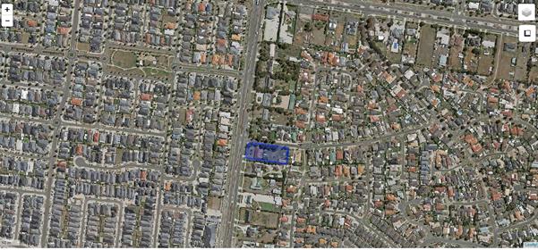
Subject Site and Surrounding Area
2. Discussion
Proposal
The application proposes the use of the existing dwelling for a caretaker’s house and use and development of a place of assembly and indoor recreation facility (community centre). The existing galvanized iron shed and garden shed on the site will be demolished to facilitate the development.
A purpose built extension is to be constructed to the rear of the existing dwelling. This will consist of a part single story, part double storey building which will be used for the community centre / recreation centre.
The existing dwelling will largely be retained in its current form with four (4) bedrooms, living and lounge area, kitchen and meals area and a double garage. It is proposed to construct a single storey extension to the rear of the dwelling accessed off the meals area, to form male and female amenities / bathroom area and a gym area. This area will wrap round a central courtyard which has a pergola covering part of the area. A double storey building is proposed to be constructed to the rear of this which will be used for sports at ground floor with part of the first floor to be used for multi purposes associated with the community centre. Entry to facility will be via a number of double doors located around the multipurpose hall. Access is also available from the courtyard area and the existing dwelling will retain its front entrance facing Tarneit Road.
Car parking is proposed to the front and rear of the site with a total of 35 spaces provided for. Access to the site is proposed off Abbotswood Drive via two new crossovers on the northern boundary. This is proposed to operate in a one way in (accessed to the north east of the site) and one way out (accessed via the north west of the site) system. The existing crossover to Tarneit Road is to be removed. Vegetable gardens provide a buffer between the rear car parking area and the dwelling at 35 Abbotswood Drive to the rear.
The facility will be staffed by three (3) people. The proposed hours of operation are varied depending on what uses will be occurring (e.g. gymnasium / sports hall use / personal development) but are generally proposed between:
o Monday – Thursday: 8am-9pm;
o Friday 8am-10pm;
o Saturday - various hours between 10am-10pm; and
o Sunday - various hours between 10am-6pm
Planning Permit Triggers
Pursuant to Table 1 at Clause 32.08-1 (General Residential Zone), a permit is required to use the land for a place of assembly and an indoor recreation facility. Pursuant to Clause 32.08-6 a planning permit is also required for buildings and works associated with a section 2 use. Pursuant to Clause 43.02-2 (Design and Development Overlay) a permit is required to construct a building or construct or carry out works.
Planning Policy
State Planning Policy Framework
The following clauses of the SPPF are relevant to the consideration of this application:
Clause 15.01-1 Urban Design
Objective
To create urban environments that is safe, functional and provides good quality environments with a sense of place and cultural identity.
Clause 15.01-2 Urban Design Principles
Objective
To achieve architectural and urban design outcomes that contribute positively to local urban character and enhance the public realm while minimising detrimental impact on neighbouring properties.
Clause 17.01-1 Business
Objective
To encourage development which meet the communities’ needs for retail, entertainment, office and other commercial services and provides net community benefit in relation to accessibility, efficient infrastructure use and the aggregation and sustainability of commercial facilities.
Clause 19.02-3 Cultural Facilities
Objective
To develop a strong cultural environment and increase access to arts, recreation and other cultural facilities.
Response
State Policy recognises that there is a need to develop a strong cultural environment and increase access to arts, recreation and other cultural facilities (Clause 19.02-3 Cultural Facilities) and Clause 17.01-1 Business seeks to encourage development which meet the communities’ needs for entertainment and other commercial services and provides net community benefit in relation to accessibility, efficient infrastructure use and the aggregation and sustainability of commercial facilities.
State Policy also requires development to respond to its context in terms of urban character, and surrounding landscape (Clause 15.01 Urban Environment) and it is not considered that the proposal effectively responds to the surrounding character of the area.
Whilst the proposal is in accordance with State Policy which seeks to enhance access to a range of recreational and cultural facilities for communities, the proposal will not result in a positive architectural design outcome which contributes to local urban character as sought by Clause 15.01-2 Urban Design Principles.
Municipal Strategic Statement and Local Planning Policy Framework
The following clauses of the MSS and LPPF are relevant to the consideration of this application:
Clause 21.06-1 Urban Environment
Objective 1
To improve the quality of development through improved design, siting and landscaping.
Clause 21.08-1 Economic Growth
Objective 1
To facilitate new development and employment opportunities in Wyndham.
Clause 21.10-1 Community Facilities
Objective 1
To ensure responsible development of new physical, social and economic infrastructure to meet the needs of the community during rapid growth.
Response
Clause 21.10-1 Community Facilities recognises that one of the greatest challenges for Wyndham will be the capacity of the city to keep up with the demand for infrastructure and services, and to maintain and build the sense of community needed to assure the safety and wellbeing of people. Strategies set out in the policy include supporting convenient access across the municipality to a greater range of health, educational, social and recreational facilities and services, as well as developing and maintaining community facilities that are multifunctional and accessible to the community. The Policy also seeks to support appropriate recreation and community facilities that are compatible with the needs, character and socio-economic profile of the local area.
Whilst the proposed use of the land would support these objectives and strategies, it is recognised that Local policy also seeks to improve the quality of development through improved design, siting and landscaping. (Objective 1 of Clause 21.06-1 Urban Environment). It is not considered that the proposed development results in a well-designed, quality outcome for the subject site, however, as the building does not integrate with and appears to dominate the streetscape.
Clause 22.01 – Non-Residential Uses in Residential Zones Policy
This policy applies to all applications in a residential zone. The objectives of this policy are:
· To ensure non-residential uses are appropriately located having regard to the amenity of the local area and nearby residential facilities.
· To ensure the siting and design of proposed buildings and works is compatible with the surrounding area; including car parking areas and advertising signs, fencing, landscaping, lighting, open space, storage amenities and loading facilities.
· To ensure appropriate location of access points and that traffic generation does not have a detrimental impact on the existing road network or pedestrian and vehicular safety.
· To ensure that non-residential uses are designed and managed in a manner that causes minimal loss of amenity, privacy and convenience to people living in nearby dwellings in regard to intensity of use, hours of operation, any overshadowing, overlooking, noise, traffic impacts, avoidance of light spill, waste management and the provision of facilities.
It is policy to:
· Ensure that the siting and design of buildings and works including car parking areas is sympathetic to the surrounding housing and streetscape and of a scale and architectural style compatible with the residential area.
· Encourage development to include features to reduce noise, loss of privacy and to enhance the appearance of the development including landscaping to the frontage, screening and acoustic fencing to cause minimal loss of amenity, privacy and convenience of people living in nearby dwellings.
· Encourage a landscape setback of a minimum of 3 metres at the front of the property.
· Encourage non-residential uses to locate along roads that are capable of carrying anticipate traffic volumes.
· Discourage major facilities serving catchments beyond the local level in residential areas and are located in and adjacent to commercial areas or sited on roads, which avoid extra generation of traffic on residential streets.
· Ensure that any waste generated by the use or development is managed appropriately.
· Ensure all applicable development complies with SEPPN1 Environment Protection Policy (Control of Noise from Commerce, Trade & Industry).
· Ensure any security lighting used is not activated continuously but designed to respond to sensors only.
· Encourage advertising signage to be in keeping with Council’s Advertising Policy for residential areas.
· Discourage flashing and illuminated signs.
In addition to the above, the following are particular guidelines applicable to Places of Assembly:
· Encourage hours of operation that maintain the residential amenity of the area.
· Ensure compliance with N2 Environment Protection Policy (Control of Music Noise from Public Premises).
Response
Whilst the overall use of the site as a community centre / indoor recreation facility is considered generally acceptable having regard to the objectives of the policy in terms of traffic generation and effect on the amenity of the area, Council is of the opinion that the built form of the development is not appropriate in its setting.
Clause 22.01 requires the siting and design of proposed buildings and works to be compatible with the surrounding area. The proposed development is not considered to meet this objective as the design of the proposed building is not considered to be compatible with the surrounding area. The scale and intensity of the development as viewed from the public realm and adjoining properties is considered excessive and does not attempt to minimise these views, especially from the adjoining site at 661 Tarneit Road.
Whilst it is acknowledged that the height of the proposed building is within the range permitted by ResCode for residential development, it is considered that the proposal fails to acknowledge the scale of residential development in the immediate area and when considering the extent of the building in comparison to adjoining development, the extensive built form across the lot is inconsistent with existing character of the area.
The decision guidelines of Clause 22.01 require Council to consider the scale and form of the site and building design including setbacks, facade treatment, building materials, colour scheme and landscaping. It is not considered that the scale and form of the building is appropriate in its setting, having regard to the proximity of residential development in the area. The roof treatment of the two storey building provides little consistency with the roof treatment of the existing dwelling and of surrounding buildings and when viewed from adjoining sites, especially number 661 Tarneit Road, the building will appear visually obtrusive.
It is therefore not considered that the proposal is in accordance with Clause 22.01.
Zoning
General Residential Zone (GRZ)
The subject site is located within the General Residential Zone. The purpose of the General Residential Zone is:
· To implement the State Planning Policy Framework and the Local Planning Policy Framework, including the Municipal Strategic Statement and local planning policies.
· To encourage development that respects the neighbourhood character of the area.
· To implement neighbourhood character policy and adopted neighbourhood character guidelines.
· To provide a diversity of housing types and moderate housing growth in locations offering good access to services and transport.
· To allow educational, recreational, religious, community and a limited range of other non-residential uses to serve local community needs in appropriate locations.
Response
Whilst it is generally accepted that the proposed development broadly accords with State and Local Policy such that it will provide community facilities in an accessible location, it is not considered that the proposed development respects the neighbourhood character of the area. This is because the proposed development of the land does not appropriately respond to the character of existing dwellings in the area and the scale and bulk of the development is considered to be inconsistent with the character of the surrounding area.
Whilst the principle of the use of the land may be generally compatible within a residential area and will assist in serving local community needs, the scale and intensity of the built form of the development is considered to be out of keeping with the character of the area and does not appropriately respond to the opportunities and constraints offered by the land.
The proposal therefore fails to meet the purpose of the zone.
Overlays
Clause 43.02 Design and Development Overlay (DDO9)
Purpose
· To implement the State Planning Policy Framework and the Local Planning Policy Framework, including the Municipal Strategic Statement and local planning policies.
· To identify areas which are affected by specific requirements relating to the design and built form of new development.
Schedule 9 to the DDO relates to the Tarneit and Sayers Road Precinct. The schedule sets out design objectives for development in this area which includes:
· To ensure consistency of building siting in the streetscape.
· To strengthen the garden settings of buildings and the tree canopy of the neighbourhood.
· To maintain the sense of openness in the streetscape and spacing between buildings.
· To retain views to buildings and gardens and provide adequate space for substantial planting.
· To minimise the loss of garden space and the dominance of driveways and car parking structures.
· To ensure car parking areas do not have a significant visual presence from street frontages.
· To avoid new buildings or extensions dominating the streetscape.
· To encourage innovative and contemporary architectural responses that make a positive contribution to the streetscape character.
· To ensure new development does not compromise the provision of future infrastructure requirements such as roads and drainage.
· To provide for safe and efficient vehicle access to and from properties along Sayers and Tarneit Roads.
The Schedule also sets out requirements which must be met before a permit can be granted:
|
Requirement |
Response |
|
Siting A new building must be set back a minimum of: · 20 metres from any front property boundary on Sayers Road or Tarneit Road. · 8 metres from the rear property boundary. · 4 metres from the side property boundary. |
The existing setback will be maintained to the existing dwelling. |
|
A new building should not exceed 9 metres in height.
|
The building does not exceed 9m in height. The maximum height is 8.65m |
|
New development should not exceed 50% site coverage and should achieve a minimum permeable area of 30%.
|
The site coverage is noted as 28.25% and the permeability is 36.5% |
|
Design New development should be a contemporary, innovative design response and incorporate articulation of facades, roof forms with eaves, and variation in building form and mass to reduce visual bulk and create open space areas and opportunities for tree planting. |
The development is considered to be of a contemporary design. During the assessment of the application, the applicant was requested to amend the plans to ensure the proposal better met the design objectives of the DDO, however, the proposal fails to achieve this. The proposed new roof forms fail to incorporate eaves which are a feature of the existing dwelling and of surrounding dwellings in the area. The two storey building also employs a cladding finish which is not a typical finish of dwellings in the area and appears to be a low quality finish to such a significant building. The building has been setback at first floor level marginally, but this does little to reduce the dominance of the building to the streetscape when viewed from most angles. The verandah wrapping around the two storey building effectively incorporates elements of the existing dwelling into the building, but does not mitigate against the overall poor design response of the building. |
|
Variation in building form and mass should be achieved across the site to avoid visual bulk and create adequate open space. |
The development transitions from an existing single storey building to a single storey extension and a two storey 8.5m high building. Whilst a variation in building form usually assists in integrating a building into the surrounding environment, the abrupt transition from a single storey building to a sheer two storey wall does little to integrate the building into the streetscape. |
|
Buildings are to respect the form, character and scale of nearby residential developments. |
It is not considered that the proposed building respects the form, character and scale of surrounding residential development. Whilst a slight pitch to the two storey roof has been achieved, the building appears in stark contrast to the traditional features of the existing dwelling and when viewed together do not appear to integrate effectively. The development appears as though there are two distinct separate entities within the site and there is little to link the two structures together. |
|
Front fencing should be approximately 20% visually permeable and not exceed 1.5 metres in height.
|
No front fencing is proposed. |
|
Vehicle Access A new development should not create more than two vehicle crossovers to the frontage. |
A maximum of two crossovers are proposed to Abbotswood Drive. |
|
Carports and garages should be located behind the front façade. |
N/A – the application is not for residential development and no new carports or garages are provided. |
|
Driveways and vehicle turning spaces must not dominate the frontage. |
The proposed accessway does not appear to dominate the frontage and the existing frontage is currently occupied by a large turning circle area for vehicles.
|
|
Landscaping A detailed landscape plan, prepared by a suitably qualified person, is to accompany all applications. |
A landscape plan has been submitted with the application which proposes a suitable landscaping response to the site. |
|
Development, including new accessways, should avoid the removal of street trees. |
The application will result in the removal of one street tree from the naturestrip. |
|
New development must include a landscape concept plan that provides for at least one large canopy tree per 600m² of the site, including at least one tree within the front and one tree within the rear setbacks. |
This is something which could be conditioned as part of any permit which may issue. |
Response
It is not considered that the proposal is consistent with the Design and Development Overlay as the proposal fails to meet design objectives set out in the schedule. The proposal provides for an extension and new building which appears dominant in the streetscape and despite the use of a marginal setback at first floor and the incorporation of a wrap-around verandah, it is considered that the development fails to meet the requirement of the design objectives or respond appropriately or make a positive contribution to the character of the area. The proposal also does not meet certain requirements which “must” be met as set out in the schedule to the Design and Development Overlay specifically in relation to design as the design response is considered to be inadequate and inappropriate when considered in the context of surrounding development.
The Design Guidelines of Clause 43.02 require the responsible authority to consider amongst others, whether the bulk, location and appearance of any proposed buildings and works will be in keeping with the character and appearance of adjacent buildings, the streetscape or the area. It is not considered that the proposed development is in keeping with the character and appearance of surrounding development in the area and for this reason, the proposal is not considered to meet the objectives of the Design and Development Overlay.
Particular Provisions
Clause 52.06 – Car Parking
Pursuant to Clause 52.06-2 prior to a new use commencing, the car parking spaces required under Clause 52.06-5 must be provided on the land or as approved under Clause 52.06-3 to the satisfaction of the responsible authority.
Within Clause 52.06-5, the car parking rate required for a place of assembly is 0.3 per patron and there is no specified rate for an indoor recreation facility and this is to be to the satisfaction of Council. The car parking requirement for the caretaker’s residence is two (2) spaces.
As the use is proposed to accommodate up to 80 patrons in its function as a place of assembly, the proposal generates a parking requirement of 26 spaces based on a maximum number of patrons and two spaces for the caretaker’s dwelling. An indoor recreation facility does not have a specified rate and is to the satisfaction of the Responsible Authority. 35 parking spaces are provided for the development including two (2) disabled spaces. The applicant’s Traffic Engineering Report states that the maximum number of patrons will be 80 at any one time. This equates to an empirical peak parking demand of 26 parking spaces. As 35 spaces have been provided this is considered to be reasonable as a maximum of three (3) staff members are proposed. The report also states that the rate is considered conservative given that the anticipated patronage of the building will likely be youths, the majority of which will be unable to drive and will likely be dropped off and collected or arrive on foot/bike.
Clause 52.34 - Bicycle Facilities
Clause 52.34 of the Wyndham Planning Scheme outlines the bicycle parking rates required for various land uses. The caretaker's residence is classified as a dwelling under the Planning Scheme and does not require any bicycle parking provision The Planning Scheme does not specify the parking requirements for an indoor recreation facility which the gym or sport / multi-purpose hall / room are classified as. However, the gymnasium and sports / multi-purpose hall will be utilised as a place of assembly at certain times of the week (for workshops and seminars) and at these times. The use is categorised as a place of assembly attracting a statutory requirement of one space to each 1.500sqm of net floor area to employees, and 2 plus 1 to each 1.500sqm of net floor area for visitors.
The applicant undertook an empirical assessment of bicycle requirements and determined that a peak bicycle parking demand of two (2) spaces would be relevant for the proposal. The application proposes to incorporate 32 bicycle racks which exceeds the requirements. As the development will serve young people and young adults, it is likely that these spaces will be heavily utilised by patrons. As a gym is proposed as part of the development, an amenities area including showers and changing areas are provided.
General Provisions
Clause 65 – Decision Guidelines
Assessment of this application against the guidelines of Clause 65, finds that this proposal is not generally in accordance with these guidelines having regard to the the State Planning Policy Framework and the Local Planning Policy Framework, including the Municipal Strategic Statement and local planning policies, the purpose of the General Residential Zone and matters to be considered under the Design and Development Overlay
Referrals
There is no requirement under Clause 66.02 of the Wyndham Planning Scheme for the application to be referred to any external authorities. The application was referred internally within Council. The following comments have been provided:
|
Referral Authority |
Comments |
|
Building Department |
The following comments were provided:
1. Lift access is required to the first floor multipurpose room (Class 9b building). 2. Circulation space is required in the ground floor area of the stairways to allow for the extensions to the handrails as required by AS 1428.1. 3. Check to see if the property is connected to sewerage. If not, the application needs to be referred to the Environmental Health Department. 4. A building permit is required.
Officer Response : Comments noted and the applicant would have been required to address these issues to ensure they would be able to obtain a building permit. This would have likely resulted in changes to the plans to show lift access. It is noted that the application was referred to Health in reference to the connection to the sewerage system. |
|
Environment and Sustainability |
The following conditions were provided: 1. Prior to the commencement of any works, including works required by other authorities, a Site Environmental Management Plan must be submitted to and approved by the Responsible Authority. When approved, the Site Management Plan will be endorsed and will then form part of the permit.
The SEMP must be in accordance with Council’s SEMP template and guidelines. The approved SEMP must be implemented at all times to the satisfaction of the Responsible Authority. Any non-compliance may be enforced under the Planning and Environment Act and other related legislation.
Access to the site must be available at all times for Council representatives to monitor implementation of the SEMP. The SEMP applies for all works approved in this Permit up to where public land is handed over (and accepted) by the relevant authority and the remainder is completely in private ownership. a. Prior to commencement of works, contractors must be inducted into the SEMP and all flora and fauna conservation requirements. b. Prior to certification, the works zone must be enclosed by secure and obvious temporary fencing. The work zone fence must remain in place until works are completed. Fill, machinery and building materials must not be placed outside of the works zone. c. All litter and building waste must be contained on the site and must not be allowed to leave the site until the time it is correctly disposed of. d. All earthworks must be undertaken in a manner that will minimise soil erosion and adhere to Construction Techniques for Sediment Pollution Control (EPA 1991) or updated version. e. Any construction stockpiles, fill and machinery must be placed away from areas supporting native vegetation and drainage lines to the satisfaction of the Responsible Authority. f. Noxious weeds must be controlled. Any weed infestations resulting from soil disturbance and/or the importation of sand, gravel and other material used in the construction process must be controlled.
Officer Response: Had Council been in support of the application, a condition would have been placed on the permit.
|
|
Engineering Traffic |
The application was discussed with the Coordinator of Traffic and Transport who advised that with modifications to the access ways that the proposal would be generally acceptable in traffic terms. This would include:
· Having the eastern crossover to Abbotswood Drive as an entry and exit point instead of one way only; · Retaining the access to Tarneit Road and having this as a left turn out only; and · Removing the western crossover to Abbotswood Drive.
Officer Response: It is noted that traffic engineering has not objected to the development on traffic grounds.
|
|
Environmental Health |
The following comments were provided:
1. The property must be connected to sewer.
2. The applicant must engage a qualified acoustic engineer to conduct a detailed assessment of the proposal and a written report must be submitted to Council for consideration.
Officer Response: Had Council been in support of the application, a condition would have been placed on the permit requiring the property to be connected to the sewer system. It is noted that the applicant had supplied a detailed acoustic assessment of the proposal which recommends appropriate construction methods and mitigation measures which could be employed to minimise the impact of the proposal on the surrounding area. |
Overview of Assessment
Car Parking & Traffic
As advised under the assessment of the proposal against Clause 52.06, the required car parking spaces for the proposal are as follows:
· 24 spaces for the place of assembly function (based on maximum patron numbers of 80;
· 2 spaces for the caretakers residential dwelling; and
· The indoor recreation facility rate is to the satisfaction of Council.
The applicant’s Traffic Engineering Report states that there will be a peak parking demand of 26 parking spaces and they estimate that this rate is considered conservative given that the anticipated patronage of the building will likely be youths, many of which would likely arrive on foot, on bike or be dropped off. Given the 35 spaces on site and low staff numbers the car parking provision is considered reasonable and acceptable.
Consideration of the proposed access to the site was also given and Council’s traffic engineers considered the proposal and had no objection to the proposal on traffic grounds subject to modifications to the proposed access arrangements:
· Having the eastern crossover to Abbotswood Drive as an entry and exit point instead of one way only;
· Retaining the access to Tarneit Road and having this as a left turn out only; and
· Removing the western crossover to Abbotswood Drive.
Noise
Potential amenity impacts arising as a result of noise have been considered as part of the assessment of this application. A number of objections have cited noise concerns as a result of patrons arriving and departing the premises, the potential for youths to gather outside the premises generating noise as well as concern for noise arising from the air conditioning and heating equipment. Whilst there is potential for noise to be generated from patrons arriving and departing the premises, it is considered that this would be over a short period and unlikely to detrimentally affect surrounding properties over a long period. In addition, there is considered to be a generous setback to the nearest properties to the rear of and south of the site, which should provide some noise buffering and an acoustic fence would provide further buffering from noise. A patron management plan would also typically have been required to provide advice on how such issues are managed.
The applicant has also submitted an acoustic assessment which provided typical noise limits for the uses on site and provided recommendations to reduce noise levels to the recommended noise levels. This included recommendations for construction techniques to address acoustic issues including specifications for construction materials and the provision of an acoustic barrier along the northern, southern and eastern boundaries. The report concludes that ‘The recommended precautions in construction will serve the dual purposes of limiting noise propagation to the requirements of the EPA. The mechanical plant and equipment with sensible selection and location may require minor precautions to enable compliance with SEPP N-1 and to reduce internal levels suitable for the intended use’. It is considered that the noise concerns raised by the objectors could have been addressed by way of suitable conditions had Council been in support of the application.
Septic System
It is noted that the subject site is currently served by a septic system and Council’s Environmental Health Department had requested that the centre be connected to a reticulated sewer system prior to the commencement of use. This is typically addressed by planning condition.
Internal Layout and Elevational Treatments
The purpose built facility has been laid out with the existing dwelling serving as the caretakers dwelling, a single storey amenities and gym area and a two storey multi-purpose / sports hall. There are numerous entrances to the building in and around the multi-purpose hall, as well as via the courtyard area in the centre of the site. This does result in a lack of an identifiable entrance to the dwelling.
The single storey extension has been designed to integrate with the existing dwelling on the site, however, the two story building results in sheer wall against this and this results in a large, box like structure to the site which does not integrate well into the streetscape. Whilst it is acknowledged that there is vegetation on the northern boundary of the site which may screen aspects of the development, the building will be in clear view from adjoining properties to the south and east and it is not considered that the outlook from these properties would be acceptable given the scale and massing of the proposed building.
Material use comprises red brick to the single storey extension to match the existing dwelling with the two storey dwelling comprising a mix of brown coloured panel metal cladding and grey metal cladding as well as first floor symmetrical glazing. A metal framed verandah with latticework is proposed to wrap around the two storey building and the roof of the building is proposed to be a grey metal colorbond roof with a central ridge and gable end treatment to the north and south.
It is not considered that the overall design, scale and massing of the proposed development is in keeping with the character of the surrounding area and the proposal does not respond to the context of the subject site and surrounding area.
Landscaping and Fencing
A landscaping plan has been provided which indicates that an appropriate landscaping treatment has been proposed for the site. This includes the retention of the band of tall, native trees located along the northern boundary of the site. One tree requires removal as it conflicts with the north-eastern corner of the proposed building. Some smaller trees and shrubs along the rear boundary will also be removed and are proposed to be replaced as detailed in the landscaping plans. Overall, the landscaping treatment to the site is considered acceptable as it provides for enhanced landscaping within the front setback and along the southern and rear boundaries and retains the existing band of native trees along the northern boundary. Native vegetation on the site does not trigger the requirement for a planning permit as the vegetation is planted and therefore exempt under Clause 52.17-7.
A 1.8m timber paling fencing currently exists along the southern boundary and eastern boundary and there is a 1.8m galvanized fence to the northern boundary. The western, front, boundary is open to the street. This fencing would require upgrading to an acoustic fence in accordance with recommendations set out in the Acoustic Report accompanying the application.
Hours of Operation
The facility will be staffed by three (3) people. The proposed hours of operation are varied depending on what uses will be occurring (e.g. gymnasium / sports hall use / personal development) but are generally proposed between:
o Monday – Thursday: 8am-9pm;
o Friday 8am-10pm;
o Saturday - various hours between 10am-10pm; and
o Sunday - various hours between 10am-6pm
Patron numbers are also proposed to be varied depending on what uses are occurring at the time. The maximum number of patrons are expected on a Saturday afternoon between 1.30pm and 4pm when the sports and multipurpose hall is proposed to be used as well as an area for community interest seminars. On week days, patron numbers are not anticipated to exceed 20 when the gym is proposed to be used by young people.
Overall, the proposed hours are considered consistent with what is expected of a community centre facility for youths. The facility will open until 10pm on Fridays and Saturdays. Clause 22.01 Non-Residential Uses in Residential Areas encourages hours of operation that maintain the residential amenity of the area for places of assembly. Given the site’s location, adjacent to Tarneit Road which is a main road, the proposed hours of operation are considered reasonable. These hours are along the lines of other places of assembly permitted in the area (e.g. 803 Sayers Road).
3. City Plan/QCP
1.2 Community engagement and building - To actively engage with the community to capture diverse perspectives and opportunities to improve the quality of Council decisions on policies, services and programs. To strengthen the capacity of citizens and community groups to participate in community life by providing opportunities for individuals to acquire knowledge, confidence, skills and experience.
4. Financial Implications
All costs associated with the construction of the community centre and access points would be borne by the developer.
5. Social Implications
The proposed development would provide for a service for youths in the community to service the wider residential area.
6. Environmental Implications
A number of trees (a mixture of native and exotic) are proposed for removal. A band of native trees along the northern boundary are proposed to be retained and a detailed landscaping plan has been submitted indicating landscaping treatment to the site.
7. Economic/Employment Considerations
There are no adverse economic implications for Council. The proposal will result in short term employment in the construction industry and long term employment for staff of the community centre.
8. Community Consultation
The application was advertised pursuant to Section 52 of the Planning & Environment Act 1987 by way of letters to adjoining owners and occupiers and also by placing a notice on the subject site for a period of 14 days.
As a result of the advertising process, a total of eighteen (18) objections were received. The main points of objection are summarised and addressed below:
|
Issue |
Response |
|
Traffic – Increased traffic congestion around the junction with Tarneit Road and Abbotswoods Drive, No data for Traffic Assessment – no supporting evidence that the impact on traffic is negligible,
|
The Traffic Assessment submitted with the application anticipates that the peak time for the use will occur on Saturdays between 1.30pm and 4pm. The assessment anticipates that during this time up to 26 of the 35 spaces will be occupied by vehicles and this results in 26 movements to and from the site within an hour. The assessment has considered that such movements are considered negligible and unlikely to have a significant impact on the existing road network, which will likely predominantly be Tarneit Road which is a secondary arterial route. |
|
Access- Access should be off Tarneit Road
|
The applicant chose not to provide access for the development off Tarneit Road in order to reduce potential conflict on that major road. The applicant did advise, however, that should access be required to be provided off Tarneit Road they could seek to accommodate this. Council’s Traffic and Transport Coordinator did not object to the proposal on traffic grounds and stated that it would be appropriate to have retained the access to Tarneit Road had Council been in support of the overall application. |
|
Insufficient Parking for the development - 40 spaces on site is inadequate
|
The development proposes to provide 35 spaces and pursuant to Clause 52.06, 26 spaces are required for the place of assembly and caretaker’s facility. The indoor recreation facility rate is not specified in Clause 52.06, however, given the nature of the facility (youths would be the predominant patrons) and the proposed level of car parking Council is generally satisfied with the parking provision of the development. |
|
Caretakers Residence - No detail on why a caretaker is required |
The application documentation advises that a caretaker is required to have a manager on site at all times and for administration purposes including centre cleaning and maintenance. |
|
Management of Centre - No detail on management of the centre and proposed patrons.
|
The application documentation advises that the proposed patrons will be young people. Whilst further detail on the patrons or management of the centre was not provided with the application or forthcoming during the Town Planning Forum, the applicant provided these details prior to the preparation of this report. This advises that the patrons will largely be school students who will come mainly from Al-Taqwa College on Sayers Road and the Islamic College of Melbourne on Wootten Road. There will also be some university students who come mainly from Victoria University, Melbourne University and Monash University. The management plan provided to Council contains details on management committee members and hours of operation. |
|
Noise – patrons arriving and departing, air conditioning/heating equipment being left on 24 hours. |
A number of objectors have raised the issue of noise arising as a result of the development. Whilst it is acknowledged that there may be some noise arising from patrons leaving, the latest opening time is 10pm on weekends and the noise from patrons leaving will likely occur over a short defined time period. A patron management plan would have be required to demonstrate that the facility can control the patrons leaving the facility at night had Council been in support of the application. It is further noted that the exits are generally not located adjacent to sensitive interfaces and the nearest sensitive interface is approximately 34m away from the rear, eastern, boundary and 30m to the dwelling on the southern boundary at 661 Tarneit Road. A standard condition of permit is used to address the requirement for heating and cooling equipment to operate at an acceptable level.
It is noted that the applicant has also submitted an acoustic assessment which provided recommendations for construction techniques as well as acoustic fencing to address acoustic issues and the report states that: The recommended precautions in construction will serve the dual purposes of limiting noise propagation to the requirements of the EPA. The mechanical plant and equipment with sensible selection and location may require minor precautions to enable compliance with SEPP N-1 and to reduce internal levels suitable for the intended use. |
|
Out of Character – building is too tall and will affect the look of the area and dominates the streetscape |
The proposed two storey building is considered to be out of character with the area. The design response does little to attempt to integrate the building into the streetscape having regard to the existing dwelling on site as well as surrounding residential development. It is agreed that the building appears dominant in the streetscape and is not an appropriate response to the site context and surroundings. |
|
Other community centres in area – A community centre already exists in the area within walking distance
|
Council does not consider the number of similar facilities in the vicinity during the determination of applications, as each application is assessed and determined on its own merits. |
|
Lighting- Lighting within the car park will light up neighbours backyards and impact privacy
|
The plans submitted with the application show low level lighting on the plans within the car parking area. No elevations have been provided, however, it is assumed these are small bollard type lighting. It is unlikely that this would result in light spill to adjoining properties however. |
|
Attracting youths - Community centre will attract young people and hoons
|
The community centre is aimed at serving young people. A patron management plan would be required to be submitted as part of any permit issued in order to address the orderly arrival and departure of patrons as well as their behaviour during operating hours. |
|
Dangerous for children to play on street - Development will mean it is unsafe for children to play in street
|
It is considered that it is the responsibility of parents/guardians to ensure the safety of children playing on the streets as they are not designated playground areas. Whilst the proposal may have resulted in more vehicles on the street, the same level of caution would have to be exercised by parents whilst supervising their children playing in streets. |
|
Devaluation of properties in area |
The Victorian Civil and Administrative Tribunal and its predecessors have generally found subjective claims that a proposal will reduce property values are difficult, if not impossible to gauge and of no assistance to the determination of a planning permit application. It is considered the impacts of a proposal are best assessed through an assessment of the amenity implications rather than any impacts upon property values. |
|
Potential for crime – damage to cars and rival gangs may gather
|
It is considered that any type of development on the site could potentially increase crime. It is noted that the site has security lighting within the car parking area and a patron management plan would be required to ensure patrons behave appropriately on site. |
|
Lack of privacy for adjoining site- inadequate fencing abutting 661 Tarneit Road
|
A 1.8m timber paling fencing currently exists along this southern boundary. There is also vegetation of a significant height along this boundary which is proposed to be retained. A condition of permit would have required this fence to be upgraded to a 2.1m acoustic fence in line with recommendations set out in the accompanying acoustic report which aims to provide further protection to the adjoining residents, although the report specifically notes that the separation from the car spaces and circulation driveways will be adequate to reduce noise levels to below sleep arousal criteria. |
Issues with nearby Community Centre- Community Centre at 653 Tarneit Road has issues with people parking on nature strip
|
Each application is assessed on its own merits and the operation of a facility in the area does not reflect on the proposed operation of the subject site. |
|
Area is residential – Community centre should be in a commercial zone
|
There is scope within the General Residential Zone to permit a community centre within residential areas as the purpose of the zone includes: To allow educational, recreational, religious, community and a limited range of other nonresidential uses to serve local community needs in appropriate locations. It is not considered that the area is highly commercialised as many of the dwellings remain in residential occupation. |
|
Effect of fumes in car park – site is not a car yard |
The impact of fumes from cars visiting the site is likely to be negligible and will not result in an unacceptable amenity impacts to surrounding properties. |
The Town Planning Community Forum
As a result of the 18 objections received, the application was a topic at the Council’s Town Planning Forum which was held on 9 May 2016. The Planning Forum meeting was an opportunity for those who objected to the proposal to air their concerns directly to Councillors. The meeting was attended by Councillors, the Manager of Town Planning, Planning Staff, the applicant/owner and those who objected to proposal. The outcome of the meeting was a presentation of views about the concerns of residents and appreciation of these concerns by Councillors and officers. No decision or recommendation was made at the Planning Forum.
The following issues were raised as the Planning Forum:
· Traffic congestion;
· Pedestrian safety;
· Lack of data in Traffic Assessment;
· Lack of access to Tarneit Road;
· Management of the centre- why is a caretaker required;
· Out of character and dominates streetscape;
· Not compliant with Clause 22.01;
· No detail on end user;
· No objection to youth centre but issues with scale and size of building;
· Not enough parking;
· Noise concerns;
· Concern with advertising process for application;
· Should be in a commercial zone;
· Concern about fumes from cars in car park;
· Who will supervise the operating hours;
· Planting must be safe; and
· People parking on Tarneit Road waiting on buses causing congestion.
The issues raised at the forum meeting are similar in nature to those addressed in the objections and have been responded to under the objections section above.
9. Conclusion
The application proposed a place of assembly and indoor recreation facility (community centre) with an onsite caretaker’s facility. Whilst the proposed development offers the opportunity to provide for a youth community facility in this residential area to serve the wider community, there are concerns about the physical attributes of the development.
Whilst objectors have raised concerns about traffic congestion arising as a result of the community centre, Council’s traffic engineering department have advised that with modifications to the proposed access, the proposal would be generally acceptable in terms of traffic generation and access.
The development has been assessed against State and Local Planning Policy and whilst the proposed development achieves compliance with some aspects of Planning Policy, overall it is not considered that the development results in an acceptable outcome for the site. The proposed built form is considered out of keeping with the surrounding character of the area and would unreasonably impact upon the immediate adjoining neighbours through its visual presentation and dominance in its setting.
Accordingly it is recommended that a Notice of Refusal to issue a Planning Permit for the use of the existing dwelling for a caretaker’s house and use and development of a place of assembly and indoor recreation facility (community centre) is issued.
|
Strategic & Town Planning |
|
Ordinary Council Meeting Monday, 27 June 2016 |
|
File No: WYP9088/16
|
|
Item No: 6.4.5 Director Sustainable Development - Dean Rochfort |
|
|
|
|
|
Planning Permit Application WYP9088/16 - 5 Vibrandia Way, Truganina - Kindergarten with Maternal Child Health |
||
Wyndham City Council intends to provide a new three-room Kindergarten and Maternal and Child Health Facility (building area 685 sqm) to the existing Mainview Reserve. The facility is to be sited to the south-west corner of Council-owned land, bounded by Mainview Boulevard, Vibrandia Way and Tylden Way, at 5 Vibrandia Way, Truganina.
It is intended for this facility to support the need for Kindergarten and Maternal Health and Child Care services to the existing residential neighbourhood and planned future adjacent education facilities.
The proposal is supported by relevant planning policy. Notice was provided of the application and no objections were received.
It is recommend that Council resolve to grant a planning permit with conditions.
Attachments
|
1. |
Proposal Plans |
Officers’ Declaration of Interests
Under Section 80C of the Local Government Act 1989 (as amended), officers providing advice
to Council must disclose any interests, including the type of interest.
Director Sustainable Development - Dean Rochfort
In providing this advice as the Director, I have no disclosable interests in this report.
Manager Town Planning - Peter Van Til
In providing this advice as the Manager, I have no disclosable interests in this report.
Principal Major Projects Planner - Tim Webb
In providing this advice as the Author, I have no disclosable interests in this report.
Key Issues
· Community Facilities
· Non Residential Uses in Residential Zones
|
RECOMMENDATION
That Council resolve to grant a planning permit for the ‘Use and Development of a Kindergarten and Maternal and Child Health Facility’ at 5 Vibrandia Way, Truganina, with the following permit conditions:
No Layout Alteration 1. The development and/or use(s) permitted by this permit as shown on the endorsed plan(s) and/or described in the endorsed documents must not be altered or modified (for any reason) except with the prior written consent of the Responsible Authority.
Landscape Plans Prior to Commencement 2. Prior to the commencement of the development hereby permitted, an electronic copy of a landscaping plan prepared by a suitably qualified person must be submitted and approved to the satisfaction of the Responsible Authority. Consideration should be given to the use of indigenous plants. All landscape plantings and treatments need to be suitable for the specific climatic and soil conditions of Wyndham. The landscape plan will show the following:
(a) Clearly drafted at a scale of 1:100 or similar with a north point and legend. (b) Clear graphics to indicate trees (deciduous or evergreen), shrubs, ground covers, grass, etc. (c) Botanical and common name, pot size, quantity, planting density and size at maturity of all plantings. (d) Notated planting specification drawings. (e) Location of all surface treatments with materials and colours notated. (f) Location and construction details of all built features including buildings, fences, letterboxes, clotheslines, storage and utility structures, etc. (g) Mark all crossovers.
Landscaping Completion & Maintenance 3. The landscape area(s) shown on the endorsed plan(s) must be planted and maintained to the satisfaction of the Responsible Authority and once landscaped must not be used for any other purpose except with the prior written consent of the Responsible Authority.
Hours of Operation 4. Except with the prior written consent of the Responsible Authority, the use permitted by this permit must operate only between the following times: Monday – Friday 7.30am – 5.30pm
Number of Children 5. Except with the prior written consent of the Responsible Authority, at no time may more than 99 child care places be offered.
Compliance with Requirements 6. The child care facility and operator must comply with the legislative requirements of the Department of Education and Early Childhood Development and all other governing authorities.
Site Environment Management Plan
7. Prior to the commencement of any works, including works required by other authorities, a Site Environmental Management Plan (SEMP) must be submitted to and approved by the Responsible Authority. When approved, the Site Management Plan will be endorsed and will then form part of the permit.
The SEMP must be in accordance with Council’s SEMP template and guidelines. The approved SEMP must be implemented at all times to the satisfaction of the Responsible Authority. Any non-compliance may be enforced under the Planning and Environment Act and other related legislation.
Access to the site must be available at all times for Council representatives to monitor implementation of the SEMP.
The SEMP applies for all works approved in this Permit up to where public land is handed over (and accepted) by the relevant authority and the remainder is completely in private ownership.
a) Prior to commencement of works, contractors must be inducted into the SEMP and all flora and fauna conservation requirements.
b) Prior to certification, the works zone must be enclosed by secure and obvious temporary fencing. The work zone fence must remain in place until works are completed. Fill, machinery and building materials must not be placed outside of the works zone.
c) All litter and building waste must be contained on the site and must not be allowed to leave the site until the time it is correctly disposed of.
d) Remnant trees that are being retained in public open space must have bollards placed around the Tree Protection Zone (as defined by Australian Standard AS 4970). The area under the tree must be mulched and planted with appropriate ground cover species to the satisfaction of the Responsible Authority.
e) All earthworks must be undertaken in a manner that will minimise soil erosion and adhere to Construction Techniques for Sediment Pollution Control (EPA 1991) or updated version.
f) Any
construction stockpiles, fill and machinery must be placed away from areas
supporting native vegetation and drainage lines to the satisfaction of the
Responsible Authority. g) Noxious weeds must be controlled. Any weed infestations resulting from soil disturbance and/or the importation of sand, gravel and other material used in the construction process must be controlled. Biodiversity Offsets
8. Prior to commencement of development, habitat compensation offsets consistent with the Biodiversity Conservation Strategy for Melbourne’s Growth Corridors (BCS), must be paid to the Department of Environment, Land, Water and Planning (DELWP), and proof of payment received by the Responsible Authority.
General Exterior Treatment 9. The exterior treatment of the building(s) permitted by this permit including all exterior decoration, materials, finishes and colours must be to the satisfaction of the Responsible Authority. The exterior treatment of the building(s) must be maintained to the satisfaction of the Responsible Authority.
Amenity 10. The use permitted by this permit must not, in the opinion of the Responsible Authority, adversely affect the amenity of the locality by reason of the processes carried on; the transportation of materials, goods, or commodities to or from the subject land; the appearance of any buildings, works or materials; the emission of noise, artificial light, vibration, smell, fumes, smoke, vapour, steam, soot, dust, waste water, waste products, grit, or oil; the presence of vermin, or otherwise.
Waste Disposal 11. An area on the subject land must be set aside for the purpose of a waste disposal / collection bin. Such area must have minimum dimensions of 2.4 metres wide by 1.8 metres deep and where located outside a building it must be screen-fenced so as not to be visible from any public road or thoroughfare. The waste bin area must be provided prior to the commencement of the use permitted by this permit, maintained and used to the satisfaction of the Responsible Authority and must not be used for any other purpose. An external area for storage of garbage and recyclable matter and for cleaning of rubbish bins is to be provided. This area must be adequately sized to contain the volume of waste generated, capable of preventing pest and animal access and designed so that it can be easily and effectively cleaned.
Delivery & Waste Collection Times 12. Delivery and waste collection times are to be restricted to 7.00am – 8.00pm Monday to Saturday and 9.00am – 8.00pm Sunday and Public Holidays, in accordance with the Environmental Protection Authorities Noise Control Guidelines Publication 1254, October 2008.
Preventing Light Spill
13. The premises must ensure that there is no light spilling into residential properties.
No Mud on Roads 14. In the event of mud, crushed rock or other debris being carried onto public roads or footpaths from the subject land, appropriate measures must be implemented to minimise the problem to the satisfaction of the Responsible Authority.
Construction Phase 15. All activities associated with the construction of the development permitted by this permit must be carried out to the satisfaction of the Responsible Authority and all care must be taken to minimise the effect of such activities on the amenity of the locality. Measures must be taken to suppress dust, noise or other emissions during construction to prevent nuisance to surrounding neighbours as defined by the Public Health and Wellbeing Act 2008. Construction and/or demolition works must comply with the requirements specified in the Environment Protection Authorities, Noise Control Guidelines Publication 1254, October 2008.
During Construction 16. Measures must be taken to suppress dust, noise or other emissions during construction to prevent nuisance to surrounding neighbours as defined by the Public Health and Wellbeing Act 2008.
Nuisance Provisions 17. No emissions from the site (noise, light, odour, dust etc) will be permitted to cause a nuisance to surrounding properties under the Public Health and Wellbeing Act 2008, Environment Protection Act 1970 or any other legislation.
Excessive Noise 18. Mechanical ventilation systems, refrigeration motors, air conditioning units or all other equipment is to be suitably located so they do not cause a nuisance under the provisions of the Public Health and Wellbeing Act 2008.
Comply with Noise Policy N2 19. Noise emissions must comply with State Environment Protection Policy (Control of Music Noise from Public Premises) No. N-2.
Baffled & Non Continuous Lighting 20. Outdoor lighting must be designed, baffled and located to the satisfaction of the Responsible Authority such that no direct light is emitted outside the boundaries of the subject land. Any security lighting is to be connected to a sensor so that illumination of the site is not continuous.
Sealed Car Park 21. Areas set aside for the parking of vehicles together with the aisles and drives must be properly formed to such levels that they can be utilised in accordance with the endorsed plan and must be drained and provided with an impervious all-weather seal coat. The areas must be constructed, drained and maintained in a continuously useable condition to the satisfaction of the Responsible Authority.
Vehicle Crossings 22. Vehicular access to the subject land from any roadway or service lane (and vice versa) must be by way of a vehicle crossing(s) constructed at right angles to the road, to suit the proposed driveway(s) and vehicles that will use the crossing. The location, design and construction of the vehicle crossing(s) must be approved by the Responsible Authority. Any existing unused crossing(s) must be removed and replaced with concrete kerb and channel and any services or infrastructure, including street trees, that require relocation or modification as a result of proposed crossovers must be relocated or modified at the permit holders cost and to the satisfaction of the Responsible Authority or relevant service authority.
Parking in Streets 23. Vehicles under the control of the operator under this permit or his/her staff must not be parked in the streets nearby. The operator must use his/her best endeavours to ensure that customer and visitor vehicles are not parked in the streets nearby.
Car Parking to be Clearly Indicated 24. The boundaries of all car spaces, access and egress lanes and the direction in which vehicles should proceed along the lanes must at all times be clearly indicated on the ground to the satisfaction of the Responsible Authority.
Directional Sign 25. A sign or signs must be provided to the satisfaction of the Responsible Authority to direct drivers to the on-site car parking area(s). Such sign(s) must be located in the vicinity of the frontage of the subject land and maintained to the satisfaction of the Responsible Authority. The sign(s) must not exceed 0.3 square metres in area.
Disabled Parking Identification 26. Disabled parking bays must be adequately identified by the use of both signs and linemarking.
Use of Parking Areas 27. Areas set aside for the parking and movement of vehicles as shown on the endorsed plan(s) must be maintained in a usable and safe condition to the satisfaction of the Responsible Authority and made available for such use and must not be used for any other purpose.
Loading and Unloading 28. The loading and unloading of vehicles and the delivery of goods must at all times be undertaken within the boundaries of the subject land.
Works Prior to Commencement of Use 29. The use permitted by this permit must not be commenced until:
(a) the parking area(s) shown on the endorsed plan(s) have been constructed to the requirements and satisfaction of the Responsible Authority; and
(b) the garden and landscape area(s) shown on the endorsed plan(s) have been planted to the requirements and satisfaction of the Responsible Authority.
Drainage Engineering Conditions
30. The whole of the subject land, including landscaped and paved areas, must be drained to the legal point of discharge to the satisfaction of the Responsible Authority.
31. The stormwater runoff generated from the whole of the subject land, including landscaped and paved areas, must not adversely flood neighbouring properties.
32. If new or additional drainage discharge point is required for the subject land, a separate legal point of discharge permit must be obtained from Council’s Engineering Department.
Waste Water Discharge Standards 33. All waste water generated onsite must comply with City West Water Trade Waste requirements and EPA waste water requirements before discharge to the reticulated sewerage system.
Completion of Development; Commencement of Use 34. This permit will expire if one of the following circumstances applies;
(a) The development and/or use is not started within two (2) years of the date of this permit; (b) The development is not completed within four (4) years of the date of this permit; (c) The use is discontinued for a period of two years.
The Responsible Authority may extend the periods referred to if a request is made in writing whereby either of the following instances apply:
(a) before or within six (6) months after the permit expiry date, where the use or development allowed by the permit has not yet started; or (b) within twelve (12) months after the permit expiry date, where the proposal allowed by the permit has lawfully started before the permit expires.
Expiry of Permit FOOTNOTE: In the event that this permit expires or the subject land is proposed to be used or developed for purposes different from those for which this permit is granted, there is no guarantee that a new permit will be granted. If a new permit is granted then the permit conditions may vary from those included on this permit having regard to changes that might occur to circumstances, the planning scheme or policy.
No Further Signs Without Consent FOOTNOTE: Except where no permit is required under the provisions of Clauses 52.05 of the Wyndham Planning Scheme, no advertising signs may be constructed or displayed without a permit.
Building Approval FOOTNOTE: This permit is issued pursuant to the provisions of the Wyndham Planning Scheme and does not relieve the permit holder of the necessity to obtain a building permit pursuant to the Building Act 1993 prior to commencement of any construction or works on any part of the site.
Health Department FOOTNOTE: Separate approval must be obtained from Councils’ Environmental Health Department and any other relevant authority prior to the commencement of the use and/or development. Environmental Health Unit Registration FOOTNOTE: All food premises as defined by the Food Act 1984 must register with Council's Environmental Health Unit prior to commencing operation.
FOOTNOTE: The proposed food premises must be designed in accordance with the requirements of the FSANZ Food Standards Code and Australian Standard 4674-2004. An application must be made to Council's Environmental Health Unit to have the design assessed for compliance prior to any work commencing.
FOOTNOTE: Sanitary and amenity facilities must be provided in accordance with the requirements of the Building Code of Australia 2006.
Road Opening / Crossovers
FOOTNOTE: Any new or modified crossovers require separate approval from Council's Roads Development Section. Town Planning stamped approved plans must be presented when applying for Road Opening Permits. The location, design and construction of the vehicle crossing(s) is to be in accordance with Council’s standard drawings - see http://www.wyndham.vic.gov.au/building_planning/engineering/crossoverpermits. Any services or infrastructure, including any services within 1.0m (eg. light pole) and street trees within 3.0m of the proposed crossover will require relocation and/or compensation (note: trees will not survive replanting so compensation is required) payable at the permit holder’s cost and to the satisfaction of the Council.
|
|
CRS Glenn Goodfellow / John Gibbons
That Council resolve to grant a planning permit for the ‘Use and Development of a Kindergarten and Maternal and Child Health Facility’ at 5 Vibrandia Way, Truganina, with the following permit conditions:
No Layout Alteration 1. The development and/or use(s) permitted by this permit as shown on the endorsed plan(s) and/or described in the endorsed documents must not be altered or modified (for any reason) except with the prior written consent of the Responsible Authority.
Landscape Plans Prior to Commencement 2. Prior to the commencement of the development hereby permitted, an electronic copy of a landscaping plan prepared by a suitably qualified person must be submitted and approved to the satisfaction of the Responsible Authority. Consideration should be given to the use of indigenous plants. All landscape plantings and treatments need to be suitable for the specific climatic and soil conditions of Wyndham. The landscape plan will show the following:
(a) Clearly drafted at a scale of 1:100 or similar with a north point and legend. (b) Clear graphics to indicate trees (deciduous or evergreen), shrubs, ground covers, grass, etc. (c) Botanical and common name, pot size, quantity, planting density and size at maturity of all plantings. (d) Notated planting specification drawings. (e) Location of all surface treatments with materials and colours notated. (f) Location and construction details of all built features including buildings, fences, letterboxes, clotheslines, storage and utility structures, etc. (g) Mark all crossovers.
Landscaping Completion & Maintenance 3. The landscape area(s) shown on the endorsed plan(s) must be planted and maintained to the satisfaction of the Responsible Authority and once landscaped must not be used for any other purpose except with the prior written consent of the Responsible Authority.
Hours of Operation 4. Except with the prior written consent of the Responsible Authority, the use permitted by this permit must operate only between the following times: Monday – Friday 7.30am – 5.30pm
Number of Children 5. Except with the prior written consent of the Responsible Authority, at no time may more than 99 child care places be offered.
Compliance with Requirements 6. The child care facility and operator must comply with the legislative requirements of the Department of Education and Early Childhood Development and all other governing authorities.
Site Environment Management Plan
7. Prior to the commencement of any works, including works required by other authorities, a Site Environmental Management Plan (SEMP) must be submitted to and approved by the Responsible Authority. When approved, the Site Management Plan will be endorsed and will then form part of the permit.
The SEMP must be in accordance with Council’s SEMP template and guidelines. The approved SEMP must be implemented at all times to the satisfaction of the Responsible Authority. Any non-compliance may be enforced under the Planning and Environment Act and other related legislation.
Access to the site must be available at all times for Council representatives to monitor implementation of the SEMP.
The SEMP applies for all works approved in this Permit up to where public land is handed over (and accepted) by the relevant authority and the remainder is completely in private ownership.
a) Prior to commencement of works, contractors must be inducted into the SEMP and all flora and fauna conservation requirements.
b) Prior to certification, the works zone must be enclosed by secure and obvious temporary fencing. The work zone fence must remain in place until works are completed. Fill, machinery and building materials must not be placed outside of the works zone.
c) All litter and building waste must be contained on the site and must not be allowed to leave the site until the time it is correctly disposed of.
d) Remnant trees that are being retained in public open space must have bollards placed around the Tree Protection Zone (as defined by Australian Standard AS 4970). The area under the tree must be mulched and planted with appropriate ground cover species to the satisfaction of the Responsible Authority.
e) All earthworks must be undertaken in a manner that will minimise soil erosion and adhere to Construction Techniques for Sediment Pollution Control (EPA 1991) or updated version.
f) Any
construction stockpiles, fill and machinery must be placed away from areas
supporting native vegetation and drainage lines to the satisfaction of the
Responsible Authority. g) Noxious weeds must be controlled. Any weed infestations resulting from soil disturbance and/or the importation of sand, gravel and other material used in the construction process must be controlled. Biodiversity Offsets
8. Prior to commencement of development, habitat compensation offsets consistent with the Biodiversity Conservation Strategy for Melbourne’s Growth Corridors (BCS), must be paid to the Department of Environment, Land, Water and Planning (DELWP), and proof of payment received by the Responsible Authority.
General Exterior Treatment 9. The exterior treatment of the building(s) permitted by this permit including all exterior decoration, materials, finishes and colours must be to the satisfaction of the Responsible Authority. The exterior treatment of the building(s) must be maintained to the satisfaction of the Responsible Authority.
Amenity 10. The use permitted by this permit must not, in the opinion of the Responsible Authority, adversely affect the amenity of the locality by reason of the processes carried on; the transportation of materials, goods, or commodities to or from the subject land; the appearance of any buildings, works or materials; the emission of noise, artificial light, vibration, smell, fumes, smoke, vapour, steam, soot, dust, waste water, waste products, grit, or oil; the presence of vermin, or otherwise.
Waste Disposal 11. An area on the subject land must be set aside for the purpose of a waste disposal / collection bin. Such area must have minimum dimensions of 2.4 metres wide by 1.8 metres deep and where located outside a building it must be screen-fenced so as not to be visible from any public road or thoroughfare. The waste bin area must be provided prior to the commencement of the use permitted by this permit, maintained and used to the satisfaction of the Responsible Authority and must not be used for any other purpose. An external area for storage of garbage and recyclable matter and for cleaning of rubbish bins is to be provided. This area must be adequately sized to contain the volume of waste generated, capable of preventing pest and animal access and designed so that it can be easily and effectively cleaned.
Delivery & Waste Collection Times 12. Delivery and waste collection times are to be restricted to 7.00am – 8.00pm Monday to Saturday and 9.00am – 8.00pm Sunday and Public Holidays, in accordance with the Environmental Protection Authorities Noise Control Guidelines Publication 1254, October 2008.
Preventing Light Spill
13. The premises must ensure that there is no light spilling into residential properties.
No Mud on Roads 14. In the event of mud, crushed rock or other debris being carried onto public roads or footpaths from the subject land, appropriate measures must be implemented to minimise the problem to the satisfaction of the Responsible Authority.
Construction Phase 15. All activities associated with the construction of the development permitted by this permit must be carried out to the satisfaction of the Responsible Authority and all care must be taken to minimise the effect of such activities on the amenity of the locality. Measures must be taken to suppress dust, noise or other emissions during construction to prevent nuisance to surrounding neighbours as defined by the Public Health and Wellbeing Act 2008. Construction and/or demolition works must comply with the requirements specified in the Environment Protection Authorities, Noise Control Guidelines Publication 1254, October 2008.
During Construction 16. Measures must be taken to suppress dust, noise or other emissions during construction to prevent nuisance to surrounding neighbours as defined by the Public Health and Wellbeing Act 2008.
Nuisance Provisions 17. No emissions from the site (noise, light, odour, dust etc) will be permitted to cause a nuisance to surrounding properties under the Public Health and Wellbeing Act 2008, Environment Protection Act 1970 or any other legislation.
Excessive Noise 18. Mechanical ventilation systems, refrigeration motors, air conditioning units or all other equipment is to be suitably located so they do not cause a nuisance under the provisions of the Public Health and Wellbeing Act 2008.
Comply with Noise Policy N2 19. Noise emissions must comply with State Environment Protection Policy (Control of Music Noise from Public Premises) No. N-2.
Baffled & Non Continuous Lighting 20. Outdoor lighting must be designed, baffled and located to the satisfaction of the Responsible Authority such that no direct light is emitted outside the boundaries of the subject land. Any security lighting is to be connected to a sensor so that illumination of the site is not continuous.
Sealed Car Park 21. Areas set aside for the parking of vehicles together with the aisles and drives must be properly formed to such levels that they can be utilised in accordance with the endorsed plan and must be drained and provided with an impervious all-weather seal coat. The areas must be constructed, drained and maintained in a continuously useable condition to the satisfaction of the Responsible Authority.
Vehicle Crossings 22. Vehicular access to the subject land from any roadway or service lane (and vice versa) must be by way of a vehicle crossing(s) constructed at right angles to the road, to suit the proposed driveway(s) and vehicles that will use the crossing. The location, design and construction of the vehicle crossing(s) must be approved by the Responsible Authority. Any existing unused crossing(s) must be removed and replaced with concrete kerb and channel and any services or infrastructure, including street trees, that require relocation or modification as a result of proposed crossovers must be relocated or modified at the permit holders cost and to the satisfaction of the Responsible Authority or relevant service authority.
Parking in Streets 23. Vehicles under the control of the operator under this permit or his/her staff must not be parked in the streets nearby. The operator must use his/her best endeavours to ensure that customer and visitor vehicles are not parked in the streets nearby.
Car Parking to be Clearly Indicated 24. The boundaries of all car spaces, access and egress lanes and the direction in which vehicles should proceed along the lanes must at all times be clearly indicated on the ground to the satisfaction of the Responsible Authority.
Directional Sign 25. A sign or signs must be provided to the satisfaction of the Responsible Authority to direct drivers to the on-site car parking area(s). Such sign(s) must be located in the vicinity of the frontage of the subject land and maintained to the satisfaction of the Responsible Authority. The sign(s) must not exceed 0.3 square metres in area.
Disabled Parking Identification 26. Disabled parking bays must be adequately identified by the use of both signs and linemarking.
Use of Parking Areas 27. Areas set aside for the parking and movement of vehicles as shown on the endorsed plan(s) must be maintained in a usable and safe condition to the satisfaction of the Responsible Authority and made available for such use and must not be used for any other purpose.
Loading and Unloading 28. The loading and unloading of vehicles and the delivery of goods must at all times be undertaken within the boundaries of the subject land.
Works Prior to Commencement of Use 29. The use permitted by this permit must not be commenced until:
(a) the parking area(s) shown on the endorsed plan(s) have been constructed to the requirements and satisfaction of the Responsible Authority; and
(b) the garden and landscape area(s) shown on the endorsed plan(s) have been planted to the requirements and satisfaction of the Responsible Authority.
Drainage Engineering Conditions
30. The whole of the subject land, including landscaped and paved areas, must be drained to the legal point of discharge to the satisfaction of the Responsible Authority.
31. The stormwater runoff generated from the whole of the subject land, including landscaped and paved areas, must not adversely flood neighbouring properties.
32. If new or additional drainage discharge point is required for the subject land, a separate legal point of discharge permit must be obtained from Council’s Engineering Department.
Waste Water Discharge Standards 33. All waste water generated onsite must comply with City West Water Trade Waste requirements and EPA waste water requirements before discharge to the reticulated sewerage system.
Completion of Development; Commencement of Use 34. This permit will expire if one of the following circumstances applies;
(a) The development and/or use is not started within two (2) years of the date of this permit; (b) The development is not completed within four (4) years of the date of this permit; (c) The use is discontinued for a period of two years.
The Responsible Authority may extend the periods referred to if a request is made in writing whereby either of the following instances apply:
(a) before or within six (6) months after the permit expiry date, where the use or development allowed by the permit has not yet started; or (b) within twelve (12) months after the permit expiry date, where the proposal allowed by the permit has lawfully started before the permit expires.
Expiry of Permit FOOTNOTE: In the event that this permit expires or the subject land is proposed to be used or developed for purposes different from those for which this permit is granted, there is no guarantee that a new permit will be granted. If a new permit is granted then the permit conditions may vary from those included on this permit having regard to changes that might occur to circumstances, the planning scheme or policy.
No Further Signs Without Consent FOOTNOTE: Except where no permit is required under the provisions of Clauses 52.05 of the Wyndham Planning Scheme, no advertising signs may be constructed or displayed without a permit.
Building Approval FOOTNOTE: This permit is issued pursuant to the provisions of the Wyndham Planning Scheme and does not relieve the permit holder of the necessity to obtain a building permit pursuant to the Building Act 1993 prior to commencement of any construction or works on any part of the site.
Health Department FOOTNOTE: Separate approval must be obtained from Councils’ Environmental Health Department and any other relevant authority prior to the commencement of the use and/or development. Environmental Health Unit Registration FOOTNOTE: All food premises as defined by the Food Act 1984 must register with Council's Environmental Health Unit prior to commencing operation.
FOOTNOTE: The proposed food premises must be designed in accordance with the requirements of the FSANZ Food Standards Code and Australian Standard 4674-2004. An application must be made to Council's Environmental Health Unit to have the design assessed for compliance prior to any work commencing.
FOOTNOTE: Sanitary and amenity facilities must be provided in accordance with the requirements of the Building Code of Australia 2006.
Road Opening / Crossovers
FOOTNOTE: Any new or modified crossovers require separate approval from Council's Roads Development Section. Town Planning stamped approved plans must be presented when applying for Road Opening Permits. The location, design and construction of the vehicle crossing(s) is to be in accordance with Council’s standard drawings - see http://www.wyndham.vic.gov.au/building_planning/engineering/crossoverpermits. Any services or infrastructure, including any services within 1.0m (eg. light pole) and street trees within 3.0m of the proposed crossover will require relocation and/or compensation (note: trees will not survive replanting so compensation is required) payable at the permit holder’s cost and to the satisfaction of the Council.
(CARRIED) |
1. Background
Proposal Summary
Wyndham City Council intends to provide a new three-room Kindergarten and Maternal and Child Health Facility (building area 685 sqm) to the existing Mainview Reserve.
The facility is to be sited to the south-west corner of Council-owned land, bounded by Mainview Boulevard, Vibrandia Way and Tylden Way. The site address is 5 Vibrandia Way, Truganina. It is intended for this Facility to support the need for Kindergarten and Maternal Health and Child Care services to the existing residential neighbourhood and planned future adjacent education facilities.
The proposed Mainview Kindergarten and Maternal and Child Health Care Facility forms part of an Active Open Space precinct, designed to serve the rapidly growing Truganina community. The project addresses the need for a Kindergarten and, Maternal and Child Health within the community, and will assist in building a stronger, more cohesive and sustainable neighbourhood.
Site and Surrounds
The Mainview Kindergarten and Maternal and Child Health Facility is to be located on the south-west corner of the site, to the south of the existing car park and existing West Playing Oval. The facility will have frontage to Mainview Boulevard and positioned within Council owned land. The Mainview Boulevard Playing Ovals form part of the parcel of land comprising one allotment accessed via Mainview Boulevard, Truganina.
This allotment is adjacent to a future school site (to the south), and is bounded by Mainview Boulevard to the west, Vibrandia Way to the north and Tylden Way to the east.
The site frontages are Mainview Boulevard to the west, playing ovals and parkland to the north and a future school precinct is planned for development to the south of the allotment. The site is a ‘greenfield’ site, and relatively level, ranging in grade from approximately less than 1:120. The site is dominated by grassland, consisting of introduced pasture species. No fencing exists around the perimeter of the site.
The site (5 Vibrandia Way, Truganina) is shown in the aerial photo extract below.
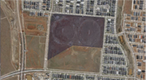
Council owns the subject site. The proposed facility will be located entirely within the subject site.
Proposal Detail
The operational purpose of the kindergarten is to provide 15 hours of kindergarten for approximately 231 children on a weekly basis, over four terms per annum.
14 Staff and children will be present in a variety of groupings Monday to Friday 7.30am – 5.30pm.
Associated on-site car parking will be provided for 100 cars via an existing car park that forms part of the Mainview Sports Pavilion. The facility is afforded clear pedestrian and vehicular access to the existing car park, from Mainview Boulevard, as well as visibility from the surrounding neighbourhood. It will form part of a recreation zone which will have proximity to an open landscaped park, sporting pavilion, playing ovals, future school, and possible future adjacent shopping centre (as part of a future town centre).
The completed Kindergarten and, Maternal and Child Health Facility will enable provision of the following services and include the following spaces:
· Maternal and Child Health/Consulting Rooms
o Two (2) Consulting Rooms
o Maternal & Child Health Foyer / Waiting Area
o One Unisex Disabled Persons Toilet
· Three Kindergarten Rooms
o Controlled Entry Foyer with access to each Playroom and Staff Amenities.
o To accommodate 33 children per room, with access to three (3) Internal Storerooms, Kinder Office, Kitchen and Children’s Toilets
o One Unisex Disabled Persons Toilet, accessible from Main Entry Foyer
o Future Outdoor Play Area
The Facility will make use of an existing car parking area, constructed to service the Reserve, including adjacent proposed Mainview Boulevard Sporting Pavilion. Of note for the car parking provision:
· The proposed new car parking area comprises four (4) bays. Three (3) are sited along the southern perimeter of the existing West Football / Cricket Oval, with the fourth bay immediately adjacent the new Sporting Pavilion.
· Car parking is accessible via a new two-way driveway, with entry/exit to/from Mainview Boulevard.
· Car parking for a total of 100 off-street vehicle parking spaces, comprised of:
o 78 No car spaces following the southern perimeter of the West Playing Oval
o 22 No car spaces provided immediately adjacent the new Sporting Pavilion
o Includes 2 No car spaces for people with a disability, immediately adjacent the proposed Facility.
· A limited number of on-street parking will be available along Mainview Boulevard.
Notice
Pursuant to Clause 67, and being an application by Council on Council land, notice of the application was provided to neighbouring owners and occupiers by way of c.100 letters and signs on site displayed for a minimum of 14 days.
No submissions were received to the notice of the application.
Referrals
No external referrals were required with the application.
The application was referred to internal Council departments for comment, as summarised in the table below.
|
Department |
Comments / Officer Response |
|
Building |
1. The site plan by TCA shows the kindergarten building as “under construction”. If the building has not yet been approved and the planning permit has not yet been issued, this note should be amended to read “proposed”. It is not considered necessary to amend the plan label. 2. A building permit is required for the proposed building. Permit footnote will be added to highlight building permit requirement. 3. The plan of subdivision submitted is not a Titles Office endorsed copy. The site is confirmed as Council land. |
|
Environment and Sustainability |
Consent with conditions re. SEMP requirement. Conditions to be applied to permit |
|
Environmental Health |
Consent with condition re. amenity. Edited conditions to be applied to permit. |
|
Engineering - Drainage |
Consent with standard conditions. Conditions to be applied to the permit. |
|
Engineering – Technical |
No response. Assumed consent. |
|
Engineering - Traffic |
No response. Assumed consent. |
|
Property |
Query building location in relation to pipeline that runs through the south-west part of the site. Applicant confirmed that the proposed building does not conflict with the pipeline. |
|
Social Development |
Initial queries were raised with the site planning. These items were discussed and resolved at an internal meeting on 02.06.2016. |
|
Urban Spaces and Civil Works |
1.Query procedure for the return of the area to public space. This item will be managed internally. 2.Query access handrails that project into the path of travel. Discussions with the building surveyor has confirmed these are permissible. 3.Query access arrangements from the town centre, ie, by foot. Internal discussions held on 02.06.2016 confirm the suitability of the location of the proposed kindergarten, until the ultimate development is brought forward in conjunction with the adjacent future school. |
2. Discussion
Permit Triggers
A permit is required for the following:
· Use of land for a sports pavilion in General Residential Zone – Clause 32.08-1
· Building and works in association with a Section 2 (permit required) use in General Residential Zone - Clause 32.08-6.
Planning Controls
Urban Growth Zone
The site zoned Urban Growth Zone (+ Schedule 1) (UGZ1). One of the key aims of the UGZ is ‘To manage the transition of non-urban land into urban land in accordance with a precinct structure plan’. In this case, the relevant plan is the Truganina South Community Precinct Structure Plan.
Truganina South PSP
Under the Community Facilities objectives (4.3.1) is ‘to integrate community facilities within the local town centre.’
Under planning and design guidelines for community facilities (4.3.3), specifically references childcare facility as a use that should be located in the Local Town Centre and its periphery.
The proposed Facility is sited within an area Zoned ‘Active Open Space and Community’.
In relation to provision 4.4 Open Space and Natural Systems, these guidelines relate to the design of public open space and reserves, providing detail on contribution, size, siting, large-scale hard and soft landscaping elements, and urban design, notably:
· ‘The active open space must include provision of sufficient car parking to service users of the site while ensuring that parking does not present physical barriers to integration of the open space with co-located community infrastructure.’
· Car park design be designed for passive surveillance and pedestrian safety and amenity; and provide adequate lighting and sight lines that support safety for users and encourage responsible use.
General Residential Zone
Under UGZ1, the applied applied zone is General Residential Zone (GRZ). The purpose is the GRZ includes: ‘To allow educational, recreational, religious, community and a limited range of other non-residential uses to serve local community needs in appropriate locations.’
Under the decision guidelines for GRZ (Clause 32.08-10), the following are relevant:
General
· The State Planning Policy Framework and the Local Planning Policy Framework, including the Municipal Strategic Statement and local planning policies.
· The purpose of this zone.
· Any other decision guidelines specified in a schedule to this zone.
Non-residential use and development
· Whether the use or development is compatible with residential use.
· Whether the use generally serves local community needs.
· The scale and intensity of the use and development.
· The design, height, setback and appearance of the proposed buildings and works.
· The proposed landscaping.
· The provision of car and bicycle parking and associated accessways.
· Any proposed loading and refuse collection facilities.
· The safety, efficiency and amenity effects of traffic to be generated by the proposal.
State Planning Policy Framework
The following State and Local planning policies are of relevance to consideration of this application:
· Clause 11 (Settlement), Clause 15 (Built Environment and Heritage), Clause 17 (Economic Development).
A review of the above policies confirms that:
· Planning is to anticipate and respond to the needs of existing and future communities through provision of zoned and serviced land for housing, employment, recreation and open space, commercial and community facilities and infrastructure (Clause 11).
· Activity centres are to be built up as a focus for high-quality development, activity and living for the whole community by developing a network of activity centres (Clause 11.01-1).
· The mix of uses in activity centres should be broadened to include a range of services over longer hours appropriate to the type of centre and needs of the population served (Clause 11.01-2).
· Neighbourhood Activity Centres are to be located within convenient walking distance in the design of new subdivisions (Clause 11.01-2).
· Planning should ensure all new land use and development appropriately responds to its landscape, valued built form and cultural context, and protects places and sites with significant heritage, architectural, aesthetic, scientific and cultural value (Clause 15).
· Land use and development planning must support the development and maintenance of communities with adequate and safe physical and social environments for their residents, through the appropriate location of uses and development and quality of urban design (Clause 15).
· Planning is to contribute to the economic well-being of communities and the State as a whole by supporting and fostering economic growth and development by providing land, facilitating decisions, and resolving land use conflicts, so that each district may build on its strengths and achieve its economic potential (Clause 17).
· Developments which meet the communities’ needs for retail, entertainment, office and other commercial services and provides net community benefit in relation to accessibility, efficient infrastructure use and the aggregation and sustainability of commercial facilities is encouraged (Clause 17.01).
Local Planning Policy Framework
Local planning policies includes the following:
· New development is to be provided for in accordance with the Truganina South Community Precinct Structure Plan, as incorporated in the Planning Scheme (Clause 21.05-1).
· Opportunities for increased employment in urban growth areas are to be facilitated (Clause 21.05-1).
· A network of current and future activity centres is to be established which satisfy a range of retail, commercial and community needs and which create a sense of place within the community (Clause 21.05-5).
· It is policy that provision of a Business Activity Centre and a Neighbourhood Activity Centre as shown in the incorporated Truganina South Community Precinct Structure Plan (Clause 22.05-3).
In relation to the Local Planning Policies, Clause 22.01 Non-Residential Uses In Residential Zones Policy is the most relevant policy, extracts of which are copied below:
22.01-2 Objectives
· To ensure non-residential uses are appropriately located having regard to the amenity of the local area and nearby residential facilities.
· To ensure the siting and design of proposed buildings and works is compatible with the surrounding area; including car parking areas and advertising signs, fencing, landscaping, lighting, open space, storage amenities and loading facilities.
· To ensure appropriate location of access points and that traffic generation does not have a detrimental impact on the existing road network or pedestrian and vehicular safety.
· To ensure that non-residential uses are designed and managed in a manner that causes minimal loss of amenity, privacy and convenience to people living in nearby dwellings in regard to intensity of use, hours of operation, any overshadowing, overlooking, noise, traffic impacts, avoidance of light spill, waste management and the provision of facilities.
22.01-3 Policy
General
It is policy to:
· Ensure that the siting and design of buildings and works including car-parking areas is sympathetic to the surrounding housing and streetscape and of a scale and architectural style compatible with the residential area.
· Encourage development to include features to reduce noise, loss of privacy and to enhance the appearance of the development including landscaping to the frontage, screening and acoustic fencing to cause minimal loss of amenity, privacy and convenience of people living in nearby dwellings.
· Encourage a landscape setback of a minimum of 3 metres at the front of the property.
· Encourage non-residential uses to locate along roads that are capable of carrying anticipated traffic volumes.
· Discourage major facilities serving catchments beyond the local level in residential areas and are located in and adjacent to commercial areas or sited on roads, which avoid extra generation of traffic on residential streets.
· Ensure that any waste generated by the use or development is managed appropriately.
· Ensure all applicable development complies with SEPPN1 Environment Protection Policy (Control of Noise from Commerce, Trade & Industry).
· Ensure any security lighting used is not activated continuously but designed to respond to sensors only.
· Encourage advertising signage to be in keeping with Council’s Advertising Policy for residential areas.
· Discourage flashing and illuminated signs.
Child Care Centres
· Locate open space and outside storage away from abutting residential uses.
· Provide acoustic fencing of a scale and design that protects adjacent residential amenity and the privacy of the children using the centre.
Overlays
The site is covered by Development Contributions Overlay + Schedule 8 (DCPO8) which brings into effect the Truganina South Precinct Development Contributions Plan.
Permit conditions will require any required payment of Development Contributions.
Particular Provisions
Clause 52.06 Car Parking requires the provision of car parking for new uses and development. The table below summaries the requirements for the proposal.
|
Use |
Ratio |
Calculation |
Requirement |
|
Childcare Centre |
0.22 to each child |
Total number of children registered : 99 children x 0.22 per child |
22 car spaces |
|
Maternal Child Health Centre (adopt Medical Centre) |
5 To the first person providing health services plus 3 To every other person providing health services |
5 (first person) + 3 (every other person): 2 staff = 5 + 3 |
8 car spaces |
|
Total |
|
|
30 car spaces |
A portion of the adjacent existing car park, will be used for off-street car-parking for the proposed Maternal and Child Care Facility.
A total of 100 car spaces are provided, comprising:
· Bay 1 - 27 (incl 2 disabled)
· Bay 2 – 45
· Bay 3 (loop road) – 6
· Bay 4 (adjacent Sporting Pavilion) 22
The provision exceeds the standard requirements.
The facility hours of operation will fall between Monday – Friday, during daylight hours. Car park peak demand is anticipated around drop-off and pick-up times, early morning and mid-afternoon, and usage will most likely be confined to the first parking bay (27 spaces), immediately adjacent the Facility. On this basis, it is unlikely a conflict of demand shall arise, given scheduled football and cricket activities will be confined largely to weekends.
Clause 52.34 Bicycle Facilities requires the provision of bicycle facilities, as follows:
|
Use |
Ratio |
Calculation |
Requirement |
|
Childcare Centre |
None specified |
- |
- |
|
Maternal Child Health Centre (adopt Medical Centre) |
Employee: 1 to each 8 practitioners. Visitors: 1 to each 4 practitioners. |
2 staff: 0.25 + 0.5 = 0.75 |
Nil |
|
Total |
|
|
Nil |
No bicycle facilities are required by the standards, and none are proposed. Being part of a public reserve, it is noted there are likely to be suitable locations for bicycle parking as part of the street furniture of the reserve.
General Provisions
Clause 65 allows the consideration of any other matter of relevance.
Policy Discussion
Overview
The provision of a new facility containing a kindergarten and maternal child health consulting rooms is broadly supported by planning policies which support the provision of community facilities. The location of the facilities within the Truganina South local town centre and periphery is specifically supported by the Truganina South PSP.
Siting
The Facility is positioned toward the ‘bottom triangle’ of the site, to allow placement of an outdoor play area with desirable easterly orientation, and provide sufficient landscape buffer to Mainview Boulevard.
The building footprint is also setback to allow for an existing main water supply line and irrigation line that traverses the site boundary.
At its closest point, the southwest corner of the facility is set back 7.0 metres from the western boundary, with the northwest corner 22.6 metres from the boundary. These setbacks are considered sufficient to enable the building to not dominate the streetscape or the open space area.
Site Access
The main entry will be clearly visible to the road, the existing car park, parkland, and adjacent neighbourhood. The site planning incorporates a new site entry/exit driveway from Mainview Boulevard. Car parking is divided into four bays, three of which are located off the driveway, along the Existing West Football / Cricket Oval perimeter.
The first two bays will service the Mainview Kindergarten and Maternal and Child Health Facility. The third car parking bay forms part of a loop driveway, which includes a drop-off area to permit managed traffic flow into and out of the car park. The fourth is positioned directly behind the Sporting Pavilion.
A well-defined entry to the street, with clear separation of pedestrian access to the facility is created, framed by an ample landscaping buffer zone.
Site Design
The main axis of the Facility is approximately north-south, allowing shaded, desirable morning (easterly) sunlight into the playrooms and MCH Consulting Rooms. Clear visibility is afforded from within the facility to the road, site frontages, and across the Kindergarten Outdoor Play Area. The built form, largely rectangular in plan, discourages illicit activity.
The facility is positioned on the site to front Mainview Bouelvard to the west, while at the same time have access from the northern/eastern side. Clear sight lines are achieved across the entire development.
The building is oriented on the site to maximise northern orientation, have minimal western orientation, thereby exclude summer and winter prevailing winds.
Built Form and Design
The rationale for the design of the built form is:
· To clearly address the site frontages: reinforce location and clear access, visibility / prominence and sense of identity.
· To convey sense of place and a building that distinctly reflects its purpose within the Truganina community.
· To make a positive, enduring and high-quality contemporary architectural contribution to the emerging diversity of the urban fabric within the neighbourhood.
The overall massing of the facility is kept to a single level, and to be low in the landscape, with strong horizontal lines. The aim is to make a contextual fit with the surrounding neighbourhood and the open plains landscape, but at the same time, contribute visual diversity to the streetscape. The overall height of the Facility from finished floor level, will range in height at the roof ridge line of approximately 3.7 metres, down to the eaves line height of approximately 2.7 metres.
Built form elements comprise a simple, minimal palette of robust materials:
· Custom Orb cladding, laid horizontally. Colorbond colour ‘Surf Mist’ finish.
· Black anodised aluminium window frames.
· Timber glazed entry doors, paint finish to match Colorbond Surfmist.
· Colorbond eaves gutters. Colorbond colour ‘Night Sky’.
· Timber balustrading, decking to covered areas, paint finish to match Colorbond colour ‘Surfmist’.
The east elevation is framed by a wide covered play area, providing ample shading and weather protection, supported by painted steel posts. This forms the dominant horizontal element to this elevation. A similarly detailed covered area announces the main entry, to the west elevation, ensuring consistency of detailing and presentation to the street. The restrained palette of materials adopts a vernacular theme, with a nod to the emerging residential neighbourhood and local elements in the nearby landscape.
Selection of materials is also predicated on use of robust, vandal resistant finishes that require minimal cyclical maintenance, ultimately returning a cost-benefit to Council. The composition of forms and materials (outlined above) ensure the building is viewed as a unified whole, with emphasis to keep the proportions low in the landscape.
Landscaping
The facility is set within the wider active open space setting. Some landscaping is shown within the proposed playground. Noting the site presents to a public street, landscaping will be required in the front of the building, via a landscape plan condition.
Pedestrian Access
Pedestrian access to the site is considered to be acceptable, noting the following:
· Good pedestrian access into the site is provided via the existing footpaths in Mainview Boulevard, Vibrandia Way and Tylden Way.
· Safe pedestrian access is provided via a wide forecourt leading to the Main Entry, and Bicycle Parking area.
· Disability persons mobility access from the car park is incorporated leading to the Main Entry.
· Tactile indicators will be incorporated where required.
· Concrete paved surfaces are to be provided immediately adjacent the new Facility, to connect the new car park to the covered entry.
· Infill permeable surfaces (compacted Granitic Sand) is provided as run-off between hard-paved surfaces and to the playing ovals.
Sustainable Design
The building incorporates a number of environmental sustainable design initiatives:
· Heat-load minimisation and passive solar design initiatives:
o Ample canopies and overhangs;
o Building footprint minimised as much as possible to reduce carbon footprint;
o Main entry airlock to control internal environment/energy loss and reduce heat loss in winter and heat gain in summer;
o Windows with solar control glazing and blinds;
o Excellent general natural light and natural ventilation together with sun shading to glazed areas;
o Natural ventilation to Children’s Playrooms, and Amenities, with BCA compliant extraction;
o Ceiling circulating fans to provide air movement on days when AC System may not be necessary to operate; and
o Energy-efficient lighting/luminaires and air-conditioning system.
· Environmental initiatives:
o Car park and access driveway area minimised as much as possible to reduce quantum of asphalt and petroleum based products in the construction whilst still providing service access.
o Water sensitive drought tolerant landscaping.
o Rain gardens.
o Sustainable and recyclable construction materials.
o Rainwater harvesting.
· Energy consumption minimisation:
o Indoor lighting controls;
o Energy-efficient lighting/luminaires;
o Zoned controls for heating, cooling and lighting to suit varying needs;
o Gas heating with ceiling circulating fans to evenly distribute heat;
o Fully encased insulated building envelope with high R value;
o High performance double glazing with solar glass;
o Solar Hot Water System; and
o Dual flush toilets and water-saving plumbing fixtures and fittings generally to meet WELS 6-star ratings.
Noise and Disturbance
The Outdoor Play Area is positioned with primary orientation toward the future proposed school site, and will not have any direct abutment with residential zones, nor the playing ovals to the north of the site. Given the facility is the other side of Forsyth Road from the nearest residential properties, it is not considered the proposal will have any undue impacts. Permit conditions will limit the hours of operation and numbers of children to that contained in the proposal.
Lighting
Permit conditions will control lighting and prevent flashing lights or light spill to residential properties.
Advertising Signage
No advertising signage is proposed in the application.
Fencing
Perimeter fencing will form part of the future Outdoor Play Area, and is to be a 2.1m high steel picket fence and posts, black powder coated finish. This will provide security for the outdoor play area but still allow transparency so as to present active interfaces. No front fencing is proposed which is supported.
Waste Collection and Services Areas
In relation to waste and services, acceptable provision is show with the following aspects:
· Wheelie bins are to be generally used for recycle and household-type rubbish collection, and will be housed in a secure location inside the Outdoor Playground. There is provision for bin hard-standing area on Mainview Boulevard for bin collection.
· Hard-paved surfaces connect the main entry, with the driveway and car park, affording easy maneuvering of waste from the building, for collection.
Summary
Overall, the proposal aligns with planning policies which encourage new community facilities in centres. With permit conditions, the amenity impacts on the surrounding area will be minimal. The proposal can be supported.
3. City Plan/QCP
2.3 Sustainable Growth - To ensure Wyndham's population growth is matched by the development of new physical, social and economic infrastructure, while protecting the City's existing assets and natural environment.
4. Financial Implications
There are no costs associated with the grant of this planning permit.
5. Social Implications
The proposal will have significant social benefits by virtue of providing a community facility to the growing community of Truganina South.
6. Environmental Implications
The environmental implications of development vacant land are negligible. The proposal incorporates a number of environment sustainable design initiatives.
7. Economic/Employment Considerations
The proposal will provide economic benefits to the area, via the provision of jobs within the new facility.
8. Community Consultation
Community consultation by way of statutory notice of the planning application was provided and no responses were received.
9. Conclusion
Overall, the proposed new community facility aligns with planning policies and will have significant community benefit. The proposal can be supported.
|
Strategic & Town Planning |
|
Ordinary Council Meeting Monday, 27 June 2016 |
|
File No: WYP9089/16
|
|
Item No: 6.4.6 Director Sustainable Development - Dean Rochfort |
|
|
|
|
|
Planning Permit Application WYP9089/16 - 5 Vibrandia Way, Truganina - Sports Pavilion |
||
Wyndham City Council intends to provide a new sports pavilion (building area 525 sqm) to the existing Mainview Reserve. The pavilion is to be sited between the two playing ovals located within the centre of Council-owned land, bounded by Mainview Boulevard, Vibrandia Way and Tylden Way, at 5 Vibrandia Way, Truganina.
This project addresses the need for a sporting facility within the Truganina community. The facility is designed to serve both football and cricket, where sporting activities can be undertaken in a safe environment, encouraging community participation.
The proposal is supported by relevant planning policy. Notice was provided of the application and no objections were received.
It is recommend that Council resolve to grant a planning permit with conditions.
Attachments
|
1. |
Proposal Plans - printed in separate document |
|
2. |
Perspective Drawings - printed in separate document |
Officers’ Declaration of Interests
Under Section 80C of the Local Government Act 1989 (as amended), officers providing advice
to Council must disclose any interests, including the type of interest.
Director Sustainable Development - Dean Rochfort
In providing this advice as the Director, I have no disclosable interests in this report.
Manager Town Planning - Peter Van Til
In providing this advice as the Manager, I have no disclosable interests in this report.
Principal Major Projects Planner - Tim Webb
In providing this advice as the Author, I have no disclosable interests in this report.
Key Issues
· Provision of Community Facilities
· Non Residential Use in Residential Zones
RECOMMENDATION
That:
1. Council resolve to grant a planning permit for the Use and development of a Sports Pavilion with associated car parking and works, at 5 Vibrandia Way, Truganina, subject to the following permit conditions:
No Alteration Layout
1. The development and/or use(s) permitted by this permit as shown on the endorsed plan(s) and/or described in the endorsed documents must not be altered or modified (for any reason) except with the prior written consent of the Responsible Authority.
No Layout Alteration
2. The development and/or use(s) permitted by this permit as shown on the endorsed plan(s) and/or described in the endorsed documents must not be altered or modified (for any reason) except with the prior written consent of the Responsible Authority.
Landscape Plans Prior to Commencement
3. Prior to the commencement of the development hereby permitted, an electronic copy of a landscaping plan prepared by a suitably qualified person must be submitted and approved to the satisfaction of the Responsible Authority. Consideration should be given to the use of indigenous plants. All landscape plantings and treatments need to be suitable for the specific climatic and soil conditions of Wyndham.
The landscape plan will show the following:
(a) Clearly drafted at a scale of 1:100 or similar with a north point and legend.
(b) Clear graphics to indicate trees (deciduous or evergreen), shrubs, ground covers, grass, etc.
(c) Botanical and common name, pot size, quantity, planting density and size at maturity of all plantings.
(d) Notated planting specification drawings.
(e) Location of all surface treatments with materials and colours notated.
(f) Location and construction details of all built features including buildings, fences, letterboxes, clotheslines, storage and utility structures etc.
(g) Mark all crossovers.
Landscaping Completion & Maintenance
4. The landscape area(s) shown on the endorsed plan(s) must be planted and maintained to the satisfaction of the Responsible Authority and once landscaped must not be used for any other purpose except with the prior written consent of the Responsible Authority.
Site Environmental Management Plan
5. Prior to the commencement of any works, including works required by other authorities, a Site Environmental Management Plan (SEMP) must be submitted to and approved by the Responsible Authority. When approved, the SEMP will be endorsed and will then form part of the permit.
The SEMP must be in accordance with Council’s SEMP template and guidelines. The approved SEMP must be implemented at all times to the satisfaction of the Responsible Authority. Any non-compliance may be enforced under the Planning and Environment Act and other related legislation.
Access to the site must be available at all times for Council representatives to monitor implementation of the SEMP.
The SEMP applies for all works approved in this Permit up to where public land is handed over (and accepted) by the relevant authority and the remainder is completely in private ownership.
a) Prior to commencement of works, contractors must be inducted into the SEMP and all flora and fauna conservation requirements.
b) Prior to certification, the works zone must be enclosed by secure and obvious temporary fencing. Fencing abutting the conservation reserve must be signposted as ‘vegetation protection zone no work permitted’. The work zone fence must remain in place until works are completed. Fill, machinery and building materials must not be placed outside of the works zone.
c) All litter and building waste must be contained on the site and must not be allowed to leave the site until the time it is correctly disposed of.
d) Remnant trees that are being retained in public open space must have bollards placed around the Tree Protection Zone (as defined by Australian Standard AS 4970). The area under the tree must be mulched and planted with appropriate ground cover species to the satisfaction of the Responsible Authority.
e) All earthworks must be undertaken in a manner that will minimise soil erosion and adhere to Construction Techniques for Sediment Pollution Control (EPA 1991) or updated version.
f) Any construction stockpiles, fill and machinery must be placed away from areas supporting native vegetation and drainage lines to the satisfaction of the Responsible Authority.
g) Noxious weeds must be controlled. Any weed infestations resulting from soil disturbance and/or the importation of sand, gravel and other material used in the construction process must be controlled.
h) Prior to felling, trees identified for removal must be examined by a qualified zoologist for the presence of fauna, including those using external nests (e.g. Common Ringtail Possums, bird nests) and tree hollows. If native fauna species are located, they are to be salvaged and relocated in accordance with all relevant legislation and approvals, further to consultation with the Department of Environment, Land, Water and Planning.
Biodiversity Offsets
6. Prior to works, habitat compensation offsets for Native vegetation, Golden Sun Moth, Spiny Rice Flower and Growling Grass Frog, consistent with the Biodiversity Conservation Strategy for Melbourne’s Growth Corridors (BCS), must be paid to the Department of Environment, Land, Water and Planning (DELWP), and proof of payment received by the Responsible Authority.
Construction Phase
7. All activities associated with the construction of the development permitted by this permit must be carried out to the satisfaction of the Responsible Authority and all care must be taken to minimise the effect of such activities on the amenity of the locality. Measures must be taken to suppress dust, noise or other emissions during construction to prevent nuisance to surrounding neighbours as defined by the Public Health and Wellbeing Act 2008.
Construction Noise
8. Construction and/or demolition works must comply with the requirements specified in the Environment Protection Authorities, Noise Control Guidelines Publication 1254, October 2008.
No Mud on Roads
9. No mud, crushed rock or other debris is to be permitted to be carried onto public roads or footpaths from the subject land. Appropriate measures must be in place at all times during construction to prevent this occurrence to the satisfaction of the Responsible Authority.
During Construction
10. Measures must be taken to suppress dust, noise or other emissions during construction to prevent nuisance to surrounding neighbours s defined by the Public Health and Wellbeing Act 2008. Construction and/or demolition works must comply with the requirements specified in the Environment Protection Authorities, Noise Control Guidelines Publication 1254, October 2008.
Drainage Engineering
11. The whole of the subject land, including landscaped and paved areas, must be drained to the legal point of discharge to the satisfaction of the Responsible Authority.
12. The stormwater runoff generated from the whole of the subject land, including landscaped and paved areas, must not adversely flood neighbouring properties.
13. If new or additional drainage discharge point is required for the subject land, a separate legal point of discharge permit must be obtained from Council’s Engineering Department.
Noise
14. Noise must be adequately controlled. Premises must consider the Environmental Protection Act 1970, State Environmental Protection Policy (Control of Noise from Commerce, Industry and Trade) No. N-1 and the Public Health and Wellbeing Act 2008.
Wastewater
15. Wastewater generated onsite must be directed to a legal point of discharge.
Baffled Lighting
16. Outdoor lighting must be designed, baffled and located to the satisfaction of the Responsible Authority such that no direct light is emitted outside the boundaries of the subject land.
Completion of Development and Commencement of Use
17. This permit will expire if one of the following circumstances applies;
(a) The development and/or use is not started within two (2) years of the date of this permit;
(b) The development is not completed within four (4) years of the date of this permit;
(c) The use is discontinued for a period of two (2) years.
The Responsible Authority may extend the periods referred to if a request is made in writing whereby either of the following instances apply:
(a) before or within six (6) months after the permit expiry date, where the use or development allowed by the permit has not yet started; or
(b) within twelve (12) months after the permit expiry date, where the proposal allowed by the permit has lawfully started before the permit expires.
Expiry of Permit
FOOTNOTE: In the event that this permit expires or the subject land is proposed to be used or developed for purposes different from those for which this permit is granted, there is no guarantee that a new permit will be granted. If a new permit is granted then the permit conditions may vary from those included on this permit having regard to changes that might occur to circumstances, the planning scheme or policy.
Building Approval
FOOTNOTE: This permit is issued pursuant to the provisions of the Wyndham Planning Scheme and does not relieve the permit holder of the necessity to obtain a building permit pursuant to the Building Act 1993 prior to commencement of any construction or works on any part of the site.
Environmental Health
FOOTNOTE: All food premises as defined by the Food Act 1984 must notify/register with Council's Environmental Health Unit prior to commencing operations.
FOOTNOTE: The food premises may require the installation of a grease trap. Enquires should be made to City West Water in order to obtain the relevant permits and approvals.
FOOTNOTE: Sanitary and amenity facilities must be provided in accordance with the requirements of the Building Code of Australia 2006.
|
CRS Peter Maynard / Glenn Goodfellow
That: 1. Council resolve to grant a planning permit for the Use and development of a Sports Pavilion with associated car parking and works, at 5 Vibrandia Way, Truganina, subject to the following permit conditions:
No Alteration Layout 1. The development and/or use(s) permitted by this permit as shown on the endorsed plan(s) and/or described in the endorsed documents must not be altered or modified (for any reason) except with the prior written consent of the Responsible Authority.
No Layout Alteration 2. The development and/or use(s) permitted by this permit as shown on the endorsed plan(s) and/or described in the endorsed documents must not be altered or modified (for any reason) except with the prior written consent of the Responsible Authority.
Landscape Plans Prior to Commencement 3. Prior to the commencement of the development hereby permitted, an electronic copy of a landscaping plan prepared by a suitably qualified person must be submitted and approved to the satisfaction of the Responsible Authority. Consideration should be given to the use of indigenous plants. All landscape plantings and treatments need to be suitable for the specific climatic and soil conditions of Wyndham. The landscape plan will show the following:
(a) Clearly drafted at a scale of 1:100 or similar with a north point and legend. (b) Clear graphics to indicate trees (deciduous or evergreen), shrubs, ground covers, grass, etc. (c) Botanical and common name, pot size, quantity, planting density and size at maturity of all plantings. (d) Notated planting specification drawings. (e) Location of all surface treatments with materials and colours notated. (f) Location and construction details of all built features including buildings, fences, letterboxes, clotheslines, storage and utility structures etc. (g) Mark all crossovers.
Landscaping Completion & Maintenance 4. The landscape area(s) shown on the endorsed plan(s) must be planted and maintained to the satisfaction of the Responsible Authority and once landscaped must not be used for any other purpose except with the prior written consent of the Responsible Authority.
Site Environmental Management Plan
5. Prior to the commencement of any works, including works required by other authorities, a Site Environmental Management Plan (SEMP) must be submitted to and approved by the Responsible Authority. When approved, the SEMP will be endorsed and will then form part of the permit. The SEMP must be in accordance with Council’s SEMP template and guidelines. The approved SEMP must be implemented at all times to the satisfaction of the Responsible Authority. Any non-compliance may be enforced under the Planning and Environment Act and other related legislation. Access to the site must be available at all times for Council representatives to monitor implementation of the SEMP. The SEMP applies for all works approved in this Permit up to where public land is handed over (and accepted) by the relevant authority and the remainder is completely in private ownership. a) Prior to commencement of works, contractors must be inducted into the SEMP and all flora and fauna conservation requirements. b) Prior to certification, the works zone must be enclosed by secure and obvious temporary fencing. Fencing abutting the conservation reserve must be signposted as ‘vegetation protection zone no work permitted’. The work zone fence must remain in place until works are completed. Fill, machinery and building materials must not be placed outside of the works zone. c) All litter and building waste must be contained on the site and must not be allowed to leave the site until the time it is correctly disposed of. d) Remnant trees that are being retained in public open space must have bollards placed around the Tree Protection Zone (as defined by Australian Standard AS 4970). The area under the tree must be mulched and planted with appropriate ground cover species to the satisfaction of the Responsible Authority. e) All earthworks must be undertaken in a manner that will minimise soil erosion and adhere to Construction Techniques for Sediment Pollution Control (EPA 1991) or updated version. f) Any construction stockpiles, fill and machinery must be placed away from areas supporting native vegetation and drainage lines to the satisfaction of the Responsible Authority. g) Noxious weeds must be controlled. Any weed infestations resulting from soil disturbance and/or the importation of sand, gravel and other material used in the construction process must be controlled. h) Prior to felling, trees identified for removal must be examined by a qualified zoologist for the presence of fauna, including those using external nests (e.g. Common Ringtail Possums, bird nests) and tree hollows. If native fauna species are located, they are to be salvaged and relocated in accordance with all relevant legislation and approvals, further to consultation with the Department of Environment, Land, Water and Planning.
Biodiversity Offsets 6. Prior to works, habitat compensation offsets for Native vegetation, Golden Sun Moth, Spiny Rice Flower and Growling Grass Frog, consistent with the Biodiversity Conservation Strategy for Melbourne’s Growth Corridors (BCS), must be paid to the Department of Environment, Land, Water and Planning (DELWP), and proof of payment received by the Responsible Authority.
Construction Phase 7. All activities associated with the construction of the development permitted by this permit must be carried out to the satisfaction of the Responsible Authority and all care must be taken to minimise the effect of such activities on the amenity of the locality. Measures must be taken to suppress dust, noise or other emissions during construction to prevent nuisance to surrounding neighbours as defined by the Public Health and Wellbeing Act 2008.
Construction Noise 8. Construction and/or demolition works must comply with the requirements specified in the Environment Protection Authorities, Noise Control Guidelines Publication 1254, October 2008.
No Mud on Roads 9. No mud, crushed rock or other debris is to be permitted to be carried onto public roads or footpaths from the subject land. Appropriate measures must be in place at all times during construction to prevent this occurrence to the satisfaction of the Responsible Authority.
During Construction 10. Measures must be taken to suppress dust, noise or other emissions during construction to prevent nuisance to surrounding neighbours s defined by the Public Health and Wellbeing Act 2008. Construction and/or demolition works must comply with the requirements specified in the Environment Protection Authorities, Noise Control Guidelines Publication 1254, October 2008.
Drainage Engineering
11. The whole of the subject land, including landscaped and paved areas, must be drained to the legal point of discharge to the satisfaction of the Responsible Authority.
12. The stormwater runoff generated from the whole of the subject land, including landscaped and paved areas, must not adversely flood neighbouring properties.
13. If new or additional drainage discharge point is required for the subject land, a separate legal point of discharge permit must be obtained from Council’s Engineering Department.
Noise
14. Noise must be adequately controlled. Premises must consider the Environmental Protection Act 1970, State Environmental Protection Policy (Control of Noise from Commerce, Industry and Trade) No. N-1 and the Public Health and Wellbeing Act 2008.
Wastewater
15. Wastewater generated onsite must be directed to a legal point of discharge.
Baffled Lighting 16. Outdoor lighting must be designed, baffled and located to the satisfaction of the Responsible Authority such that no direct light is emitted outside the boundaries of the subject land.
Completion of Development and Commencement of Use 17. This permit will expire if one of the following circumstances applies;
(a) The development and/or use is not started within two (2) years of the date of this permit; (b) The development is not completed within four (4) years of the date of this permit; (c) The use is discontinued for a period of two (2) years.
The Responsible Authority may extend the periods referred to if a request is made in writing whereby either of the following instances apply:
(a) before or within six (6) months after the permit expiry date, where the use or development allowed by the permit has not yet started; or (b) within twelve (12) months after the permit expiry date, where the proposal allowed by the permit has lawfully started before the permit expires.
Expiry of Permit FOOTNOTE: In the event that this permit expires or the subject land is proposed to be used or developed for purposes different from those for which this permit is granted, there is no guarantee that a new permit will be granted. If a new permit is granted then the permit conditions may vary from those included on this permit having regard to changes that might occur to circumstances, the planning scheme or policy.
Building Approval FOOTNOTE: This permit is issued pursuant to the provisions of the Wyndham Planning Scheme and does not relieve the permit holder of the necessity to obtain a building permit pursuant to the Building Act 1993 prior to commencement of any construction or works on any part of the site.
Environmental Health
FOOTNOTE: All food premises as defined by the Food Act 1984 must notify/register with Council's Environmental Health Unit prior to commencing operations.
FOOTNOTE: The food premises may require the installation of a grease trap. Enquires should be made to City West Water in order to obtain the relevant permits and approvals.
FOOTNOTE: Sanitary and amenity facilities must be provided in accordance with the requirements of the Building Code of Australia 2006.
(CARRIED) |
1. Background
Proposal Summary
Wyndham City Council intends to provide a new Sports Pavilion (building area 525 sqm) to the existing Mainview Reserve.
The pavilion is to be sited between the two playing ovals located within the centre of Council-owned land, bounded by Mainview Boulevard, Vibrandia Way and Tylden Way. The site address is 5 Vibrandia Way, Truganina.
It is intended for this Sports Pavilion to support the need for amenities/change facilities, a social area and kitchen/kiosk to the adjacent sporting fields, residential neighbourhood and planned future education facilities.
This project addresses the need for a sporting facility within the Truganina community. The facility is designed to serve both football and cricket, where sporting activities can be undertaken in a safe environment, encouraging community participation. The proposed Mainview Sporting Pavilion forms part of an Active Open Space precinct, designed to serve the rapidly growing Truganina community. The project will assist in building a stronger, more cohesive and sustainable local community, fostering a ‘sense of place’.
Site and Surrounds
The new sport pavilion is to be located on the centre of the site, being Council owned land. The Mainview Boulevard Playing Ovals form part of the parcel of land comprising one allotment accessed via Mainview Boulevard, Truganina.
This allotment is adjacent to a future school site (to the south), and is bounded by Mainview Boulevard to the west, Vibrandia Way to the north and Tylden Way to the east.
The site is a ‘greenfield’ site. Site is relatively level, ranging in grade from approximately less than 1:120. The site is dominated by grassland, consisting of introduced pasture species. No fencing exists around the perimeter of the site. A future school precinct is planned for development to the south of the reserve. The proposed Mainview Sports Pavilion is surrounded by the playing ovals and will form part of a future neighbourhood active open space. A future town centre is proposed to be developed to the west of the site, located off Mainview Boulevard.
The site (5 Vibrandia Way, Truganina) is shown in the aerial photo extract below.
The proposed new sports pavilion is located
entirely within the subject site.
Proposal Detail
The primary function of the pavilion will be to support sporting activity, including areas for players and officials to change and shower, areas for pre and post-match social activity and areas for storing club equipment. This function will generally take place outside of school hours 4pm to 10pm and on weekends 8am to 12 midnight. Occasionally there will be use by local schools for their sporting competitions, etc.
The completed Sports Pavilion will enable provision of the following services and include the following spaces:
· Amenities and Change Rooms
o Two sets of Change Rooms / Amenities designed to cater for both Australian Rules Football and Cricket and provide adequate amenity for the total number of sports players in any one change room. The change rooms are orientated toward the playing fields and are accessed externally.
· Public Amenities
o Controlled access from Entry/Airlock for spectators to Public Amenities (including provision of a DDA compliant Unisex Toilet).
· Meeting Room / Social Area
o Accessible from Entry / Airlock and Change Room 1, this space will allow the club to run small group activities and spectators to view the sports grounds.
· Ancillary Spaces
o Kitchen / Kiosk: A fully equipped semi-commercial kitchen with domestic appliances to service the sports club and its members. Kitchen has servery windows to service the social area (internal) and to the sports grounds (external). Area is suitable for registration as a food preparation premises.
o Umpires Change (x 2)
o First Aid
o Internal Store
o Cleaners Store
o Service Yard, Rainwater Tank, Roof Access.
o New car parking (100 cars), disabled parking (2 spaces), driveway access, entry/exit to Mainview Boulevard.
The Facility will make use of a consolidated car parking area, constructed to service the Reserve. Of note for the car parking provision:
· The proposed new car parking area comprises four bays. Three are sited along the southern perimeter of the existing West Football / Cricket Oval, with the fourth bay immediately adjacent the new Sporting Pavilion.
· Car parking is accessible via a new two-way driveway, with entry/exit to/from Mainview Boulevard.
· Traffic flow to the approach to the new Pavilion is moderated with a loop, and drop-off zone, affording clear entry and exit during busy periods.
· Car parking for a total of 100 off-street vehicle parking spaces, comprised of:
o 78 No car spaces following the southern perimeter of the West Playing Oval;
o 22 No car spaces provided immediately adjacent the new Sporting Pavilion; and
o Includes 2 No car spaces for people with a disability, immediately adjacent the proposed Facility.
Notice
Pursuant to Clause 67, and being an application by Council on Council land, notice of the application was provided to neighbouring owners and occupiers by way of c.100 letters and signs on site displayed for a minimum of 14 days,
No submissions were received to the notice of the application.
Referrals
No external referrals were required with the application.
The application was referred to internal Council departments for comment, as summarised in the table below.
|
Department |
Comments / Officer Response |
|
Building |
Building permit required. Permit footnote to highlight requirement. |
|
Environment and Sustainability |
Consent with conditions re. SEMP requirement. Conditions to be applied to permit |
|
Environmental Health |
Consent with condition re. amenity. Edited conditions to be applied to permit. |
|
Engineering - Drainage |
Consent with standard conditions. Conditions to be applied to the permit. |
|
Engineering – Technical |
No response. Assumed consent. |
|
Engineering - Traffic |
No response. Assumed consent. |
|
Property |
Verbal discussions highlighted existence of pipeline along south west section of the site. The proposed sports pavilion is not affected by the pipeline. |
|
Social Development |
Queries relating to the site location and site orientation. Internal meeting held on 02.06.2016 clarified the outstanding queries. |
|
Urban Spaces and Civil Works |
Query the site planning, compatibility with disabled persons standards, paving extent detail, access arrangements and roof lines. Internal meeting held on 02.06.2016 discussed these outstanding queries. Slightly amended plans were submitted to show extended paving under the roof. Noting that the plans have been assessed by the internal Project Control Group and that the building surveyor advises the plans are generally compliant under the Building Regs, it is considered the proposal plans are acceptable. |
2. Discussion
Permit Triggers
A permit is required for the following:
· Use of land for a sports pavilion in General Residential Zone – Clause 32.08-1
· Building and works in association with a Section 2 (permit required) use in General Residential Zone - Clause 32.08-6.
Planning Controls
Urban Growth Zone
The site zoned Urban Growth Zone (+ Schedule 1) (UGZ1). One of the key aims of the UGZ is ‘To manage the transition of non-urban land into urban land in accordance with a precinct structure plan’. In this case, the relevant plan is the Truganina South Community Precinct Structure Plan.
Truganina South PSP
Under the Community Facilities objectives (4.3.1) is ‘to integrate community facilities within the local town centre.’
The Community Facilities Delivery Statement (4.3.4), Table 1, under ‘Active Open Space’, stipulates:
One unencumbered active reserve that includes:
· 2 senior ovals that accommodate Australian Rules Football and Cricket, or alternative sporting fields.
· A pavilion providing:
o Male and female change rooms
o Male and female umpires’ change rooms
· 6 Netball and/or tennis Courts; and
· An adequately sized car park
In relation to provision 4.4 Open Space and Natural Systems, these guidelines relate to the design of public open space and reserves, providing detail on contribution, size, siting, large-scale hard and soft landscaping elements, and urban design, notably:
· ‘The active open space must include provision of sufficient car parking to service users of the site while ensuring that parking does not present physical barriers to integration of the open space with co-located community infrastructure.’
· Car park design be designed for passive surveillance and pedestrian safety and amenity; and provide adequate lighting and sight lines that support safety for users and encourage responsible use.
General Residential Zone
Under UGZ1, the applied applied zone is General Residential Zone (GRZ). The purpose is the GRZ includes: ‘To allow educational, recreational, religious, community and a limited range of other non-residential uses to serve local community needs in appropriate locations.’
Under the decision guidelines for GRZ (Clause 32.08-10), the following are relevant:
General
· The State Planning Policy Framework and the Local Planning Policy Framework, including the Municipal Strategic Statement and local planning policies.
· The purpose of this zone.
· Any other decision guidelines specified in a schedule to this zone.
Non-residential use and development:
· Whether the use or development is compatible with residential use.
· Whether the use generally serves local community needs.
· The scale and intensity of the use and development.
· The design, height, setback and appearance of the proposed buildings and works.
· The proposed landscaping.
· The provision of car and bicycle parking and associated accessways.
· Any proposed loading and refuse collection facilities.
· The safety, efficiency and amenity effects of traffic to be generated by the proposal.
State Planning Policy Framework
The following State and Local planning policies are of relevance to consideration of this application:
· Clause 11 (Settlement), Clause 15 (Built Environment and Heritage), Clause 17 (Economic Development).
A review of the above policies confirms that:
· Planning is to anticipate and respond to the needs of existing and future communities through provision of zoned and serviced land for housing, employment, recreation and open space, commercial and community facilities and infrastructure (Clause 11).
· Activity centres are to be built up as a focus for high-quality development, activity and living for the whole community by developing a network of activity centres (Clause 11.01-1).
· The mix of uses in activity centres should be broadened to include a range of services over longer hours appropriate to the type of centre and needs of the population served (Clause 11.01-2).
· Neighbourhood Activity Centres are to be located within convenient walking distance in the design of new subdivisions (Clause 11.01-2).
· Planning should ensure all new land use and development appropriately responds to its landscape, valued built form and cultural context, and protects places and sites with significant heritage, architectural, aesthetic, scientific and cultural value (Clause 15).
· Land use and development planning must support the development and maintenance of communities with adequate and safe physical and social environments for their residents, through the appropriate location of uses and development and quality of urban design (Clause 15).
· Planning is to contribute to the economic well-being of communities and the State as a whole by supporting and fostering economic growth and development by providing land, facilitating decisions, and resolving land use conflicts, so that each district may build on its strengths and achieve its economic potential (Clause 17).
· Developments which meet the communities’ needs for retail, entertainment, office and other commercial services and provides net community benefit in relation to accessibility, efficient infrastructure use and the aggregation and sustainability of commercial facilities is encouraged (Clause 17.01).
Local Planning Policy Framework
Local planning policies includes the following:
· New development is to be provided for in accordance with the Truganina South Community Precinct Structure Plan, as incorporated in the Planning Scheme (Clause 21.05-1).
· Opportunities for increased employment in urban growth areas are to be facilitated (Clause 21.05-1).
· A network of current and future activity centres is to be established which satisfy a range of retail, commercial and community needs and which create a sense of place within the community (Clause 21.05-5).
· It is policy that provision of a Business Activity Centre and a Neighbourhood Activity Centre as shown in the incorporated Truganina South Community Precinct Structure Plan (Clause 22.05-3).
In relation to the Local Planning Policies, Clause 22.01 Non-Residential Uses In Residential Zones Policy is the most relevant policy, extracts of which are copied below:
22.01-2 Objectives
· To ensure non-residential uses are appropriately located having regard to the amenity of the local area and nearby residential facilities.
· To ensure the siting and design of proposed buildings and works is compatible with the surrounding area; including car parking areas and advertising signs, fencing, landscaping, lighting, open space, storage amenities and loading facilities.
· To ensure appropriate location of access points and that traffic generation does not have a detrimental impact on the existing road network or pedestrian and vehicular safety.
· To ensure that non-residential uses are designed and managed in a manner that causes minimal loss of amenity, privacy and convenience to people living in nearby dwellings in regard to intensity of use, hours of operation, any overshadowing, overlooking, noise, traffic impacts, avoidance of light spill, waste management and the provision of facilities.
22.01-3 Policy
General
It is policy to:
· Ensure that the siting and design of buildings and works including car-parking areas is sympathetic to the surrounding housing and streetscape and of a scale and architectural style compatible with the residential area.
· Encourage development to include features to reduce noise, loss of privacy and to enhance the appearance of the development including landscaping to the frontage, screening and acoustic fencing to cause minimal loss of amenity, privacy and convenience of people living in nearby dwellings.
· Encourage a landscape setback of a minimum of 3 metres at the front of the property.
· Encourage non-residential uses to locate along roads that are capable of carrying anticipated traffic volumes.
· Discourage major facilities serving catchments beyond the local level in residential areas and are located in and adjacent to commercial areas or sited on roads, which avoid extra generation of traffic on residential streets.
· Ensure that any waste generated by the use or development is managed appropriately.
· Ensure all applicable development complies with SEPPN1 Environment Protection Policy (Control of Noise from Commerce, Trade & Industry).
· Ensure any security lighting used is not activated continuously but designed to respond to sensors only.
· Encourage advertising signage to be in keeping with Council’s Advertising Policy for residential areas.
· Discourage flashing and illuminated signs.
Overlays
The site is covered by Development Contributions Overlay + Schedule 8 (DCPO8) which brings into effect the Truganina South Precinct Development Contributions Plan.
Permit conditions will require any required payment of Development Contributions.
Particular Provisions
Clause 52.06 Car Parking requires the provision of car parking for new uses and development. The clause does not specify a standard car parking rate for sports pavilions, and so the provision is to be to the satisfaction of the Responsible Authority.
A total of 100 car spaces are provided to service the reserve, proposed kindergarten and maternal child health room facility in the south west of the site, as well as the proposed sports pavilion, for which 22 spaces are located adjacent to the proposed facility.
In terms of car parking numbers (and as a comparison), 100 car spaces compares favourably with the recently constructed Manor Lakes Sports Pavilion, where an 82-space car park has been provided. The total building area for the completed Mainview Sports Pavilion will be 525 sqm whilst the Manor Lakes Sports Pavilion is 499 sqm:
|
Facility |
Size |
Provision |
Ratio of Provision |
|
Mainview Sports Pavilion |
525 sq m |
100 cars |
5.25 sq m per car |
|
Manor Lakes Sports Pavilion |
499 sq m |
82 cars |
.08 sq m per car |
The car parking provision and accessways are considered to be acceptable.
Clause 52.34 Bicycle Facilities requires the provision of bicycle facilities, as follows:
|
Use |
Ratio |
Calculation |
Requirement |
|
Minor sports and recreation facility |
1 per 4 employees |
<4 employees |
Nil |
|
Total |
|
|
Nil |
Despite there being no statutory requirement for bicycle parking, three (3) bicycle racks (which could accommodate 6 bicycles) are shown on the plans in front of the main entry area to the pavilion. The bicycle racks can be viewed from the inside of the glazed Entry Airlock to provide a sense of security for bicycle owners. Shower and change rooms are provided within the sports pavilion. The provision is considered acceptable.
General Provisions
Clause 65 allows the consideration of any other matter of relevance.
Policy Discussion
Overview
The provision of a new sports pavilion at the Reserve is broadly supported by planning policies which support the provision of community facilities. The location of the facility within the Truganina South local town centre and periphery is specifically supported by the Truganina South PSP.
Siting
The Sporting Pavilion built mass is positioned well into the centre of the site, shifted away from the site boundaries. Together with the separation provided by the adjoining roads to three sides of the site, this avoids loss of amenity to nearby residents, and affords adequate separation, to visual bulk from the adjacent residential neighbourhood and proposed School site, allowing the building to be clearly articulated. The proposed development is circa 200m from the nearest residential properties.
Site Access
The site is accessed from the new car park and accessway driveway from Mainview Boulevard. The pavilion is adjacent to the proposed car park, and is oriented to face the car park, providing an attractive approach when entering the building from the south.
Site Design
The two main axes of the Sports Pavilion are sited to allow access and views to both Ovals. This establishes a direct relationship with the both Football / Cricket Ovals, affording clear sightlines and pedestrian access. Siting of the building in this manner also gives prominent visual exposure to passing traffic along all three main roads bordering the site, presenting an opportunity to draw and connect people to the site.
Other positive features of the site design include:
· Centrally located social area has view over both ovals.
· Pavilion oriented to face the car park, providing an attractive approach when entering the building from the south.
· Centrally located entry point from car park.
· Covered viewing areas to both ovals.
· Umpires rooms located centrally located between ovals.
· First Aid also centrally located.
· Centrally located Ambulance and service access to both ovals.
· Generally all external doors open inwards to prevent being blown off hinges in high wind conditions.
Built Form and Design
The application submissions states the rationale for the design of the built form is:
· To clearly address the site frontages: reinforce location and clear access, visibility / prominence and sense of identity.
· To convey sense of place and a building that distinctly reflects its purpose within the Truganina community.
· To make a positive, enduring and high-quality contemporary architectural contribution to the emerging diversity of the urban fabric within the neighbourhood.
With a maximum building height is 5.8m, the overall massing of the Mainview Sporting Pavilion is kept low in the landscape, with strong horizontal lines.
The Mainview Sporting Pavilion built form comprises two distinct long horizontal intersecting low block-form architectural elements to reflect the intended use and create a sense of address. These elements comprise a palette of robust materials (face brickwork, Colorbond Spandek vertical cladding).
The northwest and northeast elevations to the playing ovals are framed by wide timber-battened / Spandek-clad wide covered viewing areas, providing ample shading and weather protection, supported by timber clad steel posts. This forms the dominant horizontal element to the built form. Use of translucent Multicell panelling as highlight, allows filtered natural light into amenities areas, and adds a contrastive material, that, after-hours, is backlit, prompting activity, casting diffuse light to the exterior, and in turn, assisting in reducing vandalism/illicit activity. A smaller, similar higher central ‘box’ element articulates the Main Entry to the south elevation as an architectural focal point, and affords filtered, indirect clerestorey southern natural light into the social area.
A wrap-around façade of restrained, materials comprising vertically laid Colorbond Spandek and face brickwork, subtly references the western plains landscape, and creates architectural interest. Materials selection adopts vernacular themes, and local elements in the nearby landscape such as playground equipment (eg timber battens to covered area, timber clad steel posts), as well as use of brick, and Colorbond finishes. Selection of materials is also predicated on use of robust, vandal resistant finishes that require minimal cyclical maintenance, ultimately returning a cost-benefit to Council.
The composition of forms and materials (outlined above) ensure the building is viewed as a unified whole, with emphasis on the treatment of these elevations is to keep the proportions low in the landscape.
Landscaping
The facility is set within the wider active open space setting. A landscape plan will be required (via landscape plan condition) in order to ensure the built form appearance is appropriately softened.
Pedestrian Access
Pedestrian access to the site is considered to be acceptable, noting the following:
· Good pedestrian access into the site is provided via the existing footpaths in Mainview Boulevard, Vibrandia Way and Tylden Way.
· Disability persons mobility access from the car park is incorporated leading to the Main Entry.
· Bollards have been placed adjacent the Loading / Drop-off Zone.
· Tactile indicators will be incorporated where required.
· Concrete paved surfaces are provided immediately adjacent the new Pavilion, to connect the new car park to the covered entry, covered viewing areas to the playing ovals, and afford access onto the playing ovals themselves.
· Infill permeable surfaces (compacted granitic sand) is provided as run-off between hard-paved surfaces and to the playing ovals.
Sustainable Design
The building incorporates a number of environmental sustainable design initiatives:
· Heat-load minimisation and passive solar design initiatives:
o Northern orientation and north-facing clerestorey to the change rooms and meeting room / social area;
o Minimum western building elevation;
o Ample canopies and overhangs;
o Concrete floor slab, insulated walls and special sandwich roof insulation system;
o Building footprint minimised as much as possible to comply with Brief and to reduce carbon footprint;
o Main entry airlock to control internal environment/energy loss;
o Airlock entry to social area and public amenities to reduce heat loss in winter and heat gain in summer;
o General natural light and natural ventilation together with sun shading to glazed areas; and
o Natural ventilation to change room amenities and public amenities.
· Environmental initiatives:
o Car park and access driveway area minimised as much as possible to reduce quantum of asphalt and petroleum based products in the construction whilst still providing service access to Pavilion drop-off zone.
o Dual flush toilets and water-saving plumbing fixtures and fittings generally.
o Space for bicycle parking areas.
o Water sensitive drought tolerant landscaping.
o Rain gardens.
o Sustainable and recyclable construction materials.
o Rainwater harvesting.
· Energy consumption minimisation:
o Indoor lighting controls;
o Energy-efficient lighting/luminaires;
o Zoned controls for heating, cooling and lighting to suit varying needs;
o Gas heating with ceiling circulating fans to evenly distribute heat;
o Fully encased insulated building envelope with high R value;
o High performance double glazing with solar glass;
o High thermal performance Polycarbonate Multicell translucent highlight panels to permit natural light into amenities and change rooms;
o Roof mounted wind turbines;
o Roof mounted photovoltaic system to help reduce energy input; and
o Water efficient WELS rated fittings and appliances.
Noise and Disturbance
The siting of the building in the centre of the reserve, a large distance from the nearest sensitive uses, means that noise and disturbance will be negligible, and the proposal will not have any undue impacts. Given that the primary function of the pavilion will be to support sporting activity, and that the pavilion is sited in the centre of the reserve, it is not considered necessary to require permit condition to controls its hours of use.
Lighting
Permit conditions will control lighting and prevent flashing lights or light spill to residential properties.
Advertising Signage
No advertising signage is proposed in the application.
Fencing
There is no fencing proposed to the facility, which will ensure that an open appearance is maintained.
Waste Collection and Services Areas
In relation to waste and services, acceptable provision is show with the following aspects:
· Wheelie bins are to be generally used for recycle and household-type rubbish collection, and will be housed in a secure and screened location in the service yard, which reads as part of the building.
· There is provision for a bin hard-standing area on Mainview Boulevard for bin collection.
· Hard-paved surfaces connect the main entry, with the driveway and car park, affording easy maneuvering of waste from the building, for collection.
Summary
Overall, the proposal aligns with planning policies which encourage new community facilities in centres. With permit conditions, the amenity impacts on the surrounding area will be minimal. The proposal can be supported.
3. City Plan/QCP
2.3 Sustainable Growth - To ensure Wyndham's population growth is matched by the development of new physical, social and economic infrastructure, while protecting the City's existing assets and natural environment.
4. Financial Implications
There are no costs associated with the grant of this planning permit.
5. Social Implications
The proposal will have significant social benefits by virtue of providing a community facility to the growing community of Truganina South.
6. Environmental Implications
The environmental implications of development vacant land are negligible. The proposal incorporates a number of environment sustainable design initiatives.
7. Economic/Employment Considerations
The proposal will provide economic benefits to the area, via the provision of jobs within the new facility.
8. Community Consultation
Community consultation by way of statutory notice of the planning application was provided and no responses were received.
9. Conclusion
Overall, the proposed new community facility aligns with planning policies and will have significant community benefit. The proposal can be supported.
|
Other Reports |
|
Ordinary Council Meeting Monday, 27 June 2016 |
|
File No: 00/000/000
|
|
Item No: 6.5.1 Director Corporate Services - Steven Lambert |
|
|
|
|
|
Consideration of Submissions Regarding Council's Proposed Integrated Plan & Budget 2016/17 |
||
At the Ordinary Council Meeting on 26 April 2016, Council considered the Proposed Integrated Plan & Budget 2016/17 and invited the community to make submissions pursuant to Section 223 of the Local Government Act 1989.
Council received 3 written submissions relating to the Proposed Budget 2016/17. Council also received a letter of commendation from the Bicycle Network relating to Council’s proposed expenditure on bicycle paths.
The submissions were considered by Council at a Special Council Meeting held on Tuesday, 14 June 2016 as part of its final review and determination on the Integrated Plan & Budget for 2016/17.
Attachments
Nil
Officers’ Declaration of Interests
Under Section 80C of the Local Government Act 1989 (as amended), officers providing advice
to Council must disclose any interests, including the type of interest.
Director Corporate Services – Steve Lambert
In providing this advice as the Director, I have no disclosable interests in this report.
Manager Financial Services – Binda Gokhale
In providing this advice as the Manager, I have no disclosable interests in this report.
Key Issues
· Consideration of Submissions
· Officers Comments / Recommendations
RECOMMENDATION
Submission 1 & 2 – Joe Garra, Rate Payers Werribee South
That the following works requested by Joe Garra be completed in the 2016/17 financial year to be funded from the annual footpath works program budget.
1. Reconstruction of the Nolan Grove to Beach Road pedestrian/bicycle path
2. Pedestrian Crossing at O’Connors Rd, Werribee South
Submissions 3 – Don Lee, Hoppers Crossing resident
That Capital works at the Symons Reserve not be supported for 2016/17 as the Reserve currently meets the standard of a small local reserve under Council’s Open Space Strategy.
|
CRS Gautam Gupta / Peter Maynard
Submission 1 & 2 – Joe Garra, Rate Payers Werribee South That the following works requested by Joe Garra be completed in the 2016/17 financial year to be funded from the annual footpath works program budget. 1. Reconstruction of the Nolan Grove to Beach Road pedestrian/bicycle path 2. Pedestrian Crossing at O’Connors Rd, Werribee South
Submissions 3 – Don Lee, Hoppers Crossing resident That Capital works at the Symons Reserve not be supported for 2016/17 as the Reserve currently meets the standard of a small local reserve under Council’s Open Space Strategy.
(CARRIED) |
Discussion
A summary of each submission together with officer’s comments is outlined as per below.
Submission 1
Lodged by: Joe Garra, Rate Payers Werribee South
Summary:
Mr. Garra’s
submission expresses concern about the condition of the footpath connecting
Nolan Grove to Beach Road, Werribee South, and is requesting a reconstruction
of this path. A 2m wide concrete shared pedestrian/bicycle path is sought, as
it is used by cyclists to connect with the shared track on the south side of
Diggers Road.
The existing surface of loose rock screenings is difficult to negotiate with a wheelchair, wheeled frame or pram/pusher and there are no ramps (pram crossings) over the kerbs at either end.
Several residents are elderly and/or disabled and require adequate access to the bus stop on Beach Road.
The laneway is also used by school children accessing the school bus on the
opposite side of Diggers Road.
Officer’s Comment:
This request is supported for implementation in 2016/17 with funding available within the Footpath Capital Works program.
Submission 2
Lodged by: Joe Garra, Rate Payers Werribee South
Summary:
Mr. Garra’s
submission is a request for a new pedestrian crossing.
Following the recent construction of a footpath on the north side of Beach Road
between Finch Road and O’Connors Road, it is felt that this crossing
should been placed at the off- branch from the foreshore footpath connecting
with the off-branch from the new footpath near O’Connors Road.
This location is appropriate for a pedestrian crossing as there is convenient access to the bus stop, public toilets and the “Ängler’s Anchorage” shop.
Officer’s Comment:
This request is supported for implementation in 2016/17 with funding available within the Road Safety Program.
Submission 3
Lodged by: Don Lee, Hoppers Crossing Resident
Summary:
Mr Lee is requesting that the Symons Reserve be upgraded (situated between Symons and Cation Avenues in Hoppers Crossing).
The park was originally planted with trees and some play equipment approximately fifteen years ago. The current play area and equipment is in need of some rejuvenation and the request is for an upgrade and some new play equipment.
Mr Lee believes families within this area of Hoppers Crossing would greatly benefit from the upgrade.
Officer’s Comment:
Symons Reserve is a small local
reserve; its playground is of an older style however in good condition. It has
some seating and some tree planting has recently occurred.
As per Wyndham City’s Open Space Strategy under the classification of Local Reserve this park has all the embellishments defined for this category, therefore no redevelopment of the playground is being considered at this point.
Wyndham City will record this request and will review for future capital works programs.
1. Community Consultation
The proposed Integrated Plan & Budget 2016/17 was advertised on 27 April 2016 in the local newspaper inviting public comment and submissions. The proposed budget document has been made available for inspection;
- On Council’s website: www.wyndham.vic.gov.au
- Municipal Offices, Civic Centre
- Libraries and Community Centres throughout Wyndham
2. Communication Strategy
Council will notify those persons who have submitted written presentations to Council of the decisions relating to their requests after the adoption of the Integrated Plan & Budget 2016/17.
|
Other Reports |
|
Ordinary Council Meeting Monday, 27 June 2016 |
|
File No: 00/000/000
|
|
Item No: 6.5.2 Director Corporate Services - Steven Lambert |
|
|
|
|
|
Adoption of Council's Integrated Plan & Budget 2016/2017 |
||
At the Ordinary Meeting of Council on 26 April 2016, Council endorsed the Proposed Integrated Plan & Budget 2016/17 and invited the community to make submissions. Three submissions were received from members of the community.
Since the Proposed Integrated Plan & Budget 2016/17 was endorsed by Council in April, additional information has become available relating to the 2016/17 budget. The following report summarises the changes that are recommended to be adopted as part of the final Integrated Plan & Budget 2016/17.
Attachments
|
1. |
Attachment A - Integrated Plan & Budget 2016-2017 - printed in separate document |
|
2. |
Attachment B - Fees and Charges 2016-2017 - printed in separate document |
|
3. |
Attachment C - Rating Strategy 2016 - printed in separate document |
Officers’ Declaration of Interests
Under Section 80C of the Local Government Act 1989 (as amended), officers providing advice
to Council must disclose any interests, including the type of interest.
Director, Corporate Services – Steve Lambert
In providing this advice as the Director, I have no disclosable interests in this report.
Manager, Financial Services – Binda Gokhale
In providing this advice as the Manager, I have no disclosable interests in this report
Management Accounting Coordinator – Alana Taylor
In providing this advice as the Author, I have no disclosable interests in this report.
Key Issues
· Matters impacting the Integrated Plan & Budget 2016/17;
· Adoption of Council’s Integrated Plan & Budget for 2016/17 including:
o Strategic Resource Plan 2016/17-2019/20;
o Fees and Charges for 2016/17;
o Rating Strategy; and
o Year 4 activities and initiatives of the 2013-2017 City Plan and Service Performance Indicators.
|
RECOMMENDATION
1. That Council adopt the following new initiatives, where Cr Marcus has declared a conflict, as part of the Integrated Annual Plan & Budget for 2016/17: Werribee CBD catalyst site development project....................................... $150,000 Werribee CBD activation & marketing....................................................... $260,000 Implement integrated way finding signage in the Werribee CBD............... $ 80,000
2. That Council adopt the following capital works project to be carried forward from the 2015/16 year, where Cr Marcus has declared a conflict, as part of the Integrated Annual Plan & Budget for 2016/17: Werribee CBD activation............................................................................ $285,000
3. That Council adopt the following capital works project, to be carried forward from the 2015/16 year, where Cr Khan has declared a conflict, as part of the Integrated Annual Plan & Budget for 2016/17: 1160 Sayers Road - Masterplan ................................................................ $250,000
4. That the Council resolution in relation to agenda item 6.5.1 “Consideration of Budget Submissions” for those that have been approved by Council, be included as part of the Integrated Plan & Budget 2016/17.
5. That the Integrated Plan & Budget 2016/17 be amended for the items detailed in the discussion section of this report (compared to the 2.5% Rate Increase scenario as presented in the Proposed Integrated Plan & Budget 2016/17). In summary the financial impact of the proposed changes are: - Reduction in operating surplus........................................................... $52,000 - No change to the total capital works
6. That Council adopt the revised Integrated Plan & Budget 2016/17 as required under the Local Government Act 1989. The revised Integrated Plan & Budget 2016/17 is attached to this report and includes the following: · Comprehensive Income Statement (Attachment A, refer page 37) · Balance Sheet (Attachment A, refer page 38) · Statement of Changes in Equity (Attachment A, refer page 39) · Statement of Cash Flows (Attachment A, refer page 40) · Statement of Capital Works (Attachment A, refer page 41) · Statement of Human Resources (Attachment A, refer page 42) · Statutory disclosure incorporating rates and charges for 2016/17 to be accepted as Council’s adopted Budget, and supporting information (Attachment A – section 7 and Appendix D, refer pages 58-63 and 111-124). · Strategic Resource Plan for the 4 years from 2016/17 to 2019/20. The financial statements, human resources and performance indicators for the 4 years are contained in sections 3 and 4, pages 36 to 44. Further details on the Strategic Resource Plan are contained in section 14, pages 94-96. · Description of the Year 4 activities and initiatives of the 2013-2017 City Plan and how they will contribute to the objectives specified in the City Plan 2013-2017. This section also includes the Service Performance Indicators (Attachment A - refer pages 20-35 and 104-110).
7. That Council declare its intention to undertake a formal mid-year review of the capital works program as part of its ongoing focus to improve project governance. This may involve deferring projects that have not progressed as per the plan and/or bringing forward projects identified in future years of the Strategic Resource Plan into the 2016/17 program of works. Council may also consider those projects reliant on external funding sources should the funding become available through the course of the 2016/17 financial year. The capital works program expenditure and funding requirements will be managed through the forecast process and reported to Council on a quarterly basis.
8. That the Rating Strategy 2016 as detailed in Attachment C be adopted as part of the Integrated Plan & Budget 2016/17.
9. That
in accordance with Section 158 of the Local Government Act 1989,
Council declare the following amounts to be raised from rates and charges for
the 12 month period from General Rates................................................................................ $ 144,353,941 Municipal Charge........................................................................... $ 4,776,188 Waste Management Charge.......................................................... $ 17,879,499 Total Rates, Municipal and Service Charges................................ $ 167,009,628
Revenue in lieu of Rates................................................................ $ 168,162 Supplementary Rates.................................................................... $ 2,272,121 Total Rates and Charges............................................................... $ 169,449,911
10.
11. That in respect of recreational lands under the Cultural and Recreational Lands Act 1963 and properties owned by the Federal Government, an amount equal to 0.1617 cents for each dollar of the Capital Improved Value of the land should be payable in lieu of rates.
12. That in accordance with Section 159 of the Local Government Act 1989, Council declare a Municipal Charge of $57.04 for each rateable land for the rating period from 1 July 2016 to 30 June 2017.
13. That in accordance with Section 162 of the Local Government Act 1989, Council declare a Waste Management service charge for the collection and disposal of refuse of $243.00 for a 140 litre bin and $233.00 for each additional bin from 1 July 2016 to 30 June 2017.
14. That in accordance with Section 162 of the Local Government Act 1989, Council declare a service charge for green waste services within the garbage service area and non-rateable properties where the ratepayer has elected to use the services of $103.50 from 1 July 2016 to 30 June 2017.
15. That in accordance with Section 163 of the Local Government Act 1989 and Council’s resolution of December 2008, the annual portion of the special charges scheme for the construction of James Street will be charged to each property in the scheme.
16. That Council resolve to set the 2016/17 interest rate for outstanding rates and other property related charges in accordance with the rate of interest fixed by the Attorney General as at 1 June 2015 under the Penalty Interest Rate Act 1983. This rate (currently 9.5%) will remain in force until Council resolves to vary that rate.
17. That the fees and charges as detailed in Attachment B be adopted as part of the Integrated Plan & Budget 2016/17. Where a fee amount is set through legislation, the legislated fee amount will supersede the fee amount in the fees and charges schedule.
18. That Council declare that the Mayoral and Councillor allowances be determined at the following levels until the next general election: · The Mayoral allowance be set at $92,333 per annum, plus 9.5% superannuation guarantee contribution. · The Councillor allowance be set at $28,907 per annum, plus 9.5% superannuation guarantee contribution.
19. That in accordance with Sections 125(11), 126(4) and 130(9) of the Local Government Act 1989, Council resolve to make copies of the Integrated Plan & Budget 2016/17 available for inspection by the public.
20. That in accordance with Section 130(2) of the Local Government Act 1989, Council resolve to give public notice of its decision to adopt the Integrated Plan & Budget 2016/17.
21. That in accordance with Section 130(4) of the Local Government Act 1989, Council resolve to submit a copy of the Integrated Plan & Budget 2016/17 to the Minister within 28 days of adoption.
|
CR GLENN GOODFELLOW LEFT THE MEETING AT 9:14PM.
CR GAUTAM GUPTA RETURNED TO THE MEETING AT 9:15PM.
1. Background
Under the Local Government Act 1989, Council is required to prepare and adopt the following documents on an annual basis:
1. Annual Budget
2. Strategic Resource Plan
3. Activities and Actions from the City Plan as they relate to the current year
4. Rating Strategy
These documents include prescribed information as per the Local Government Act 1989 as well as a range of other information required by the Local Government (Finance and Reporting) Regulations 2004 which support the Act.
The Integrated Plan & Budget 2016/17 prepared for Wyndham City combines the Annual Budget, Strategic Resource Plan and City Plan into one integrated document.
2. Discussion
The Proposed Integrated Plan & Budget 2016/17 released by Council for public consultation contained two versions, one based on each of the rate increase scenarios of 2.5% or 4.5%.
Since then, we have received advice that Council’s submission for a rate increase of 4.5% has been disallowed by the ESC. Therefore the Integrated Plan & Budget 2016/17 presented for final adoption is confirmed to be based on an average increase in rates of 2.5%, consistent with the State Government imposed rate cap.
2.1. Changes impacting the 2016/17 Income Statement
Since the Proposed Integrated Plan & Budget 2016/17 was released for public consultation, more information has become available that has impacted the income statement.
The changes are as follows:
· Lower contracted rates confirmed with the Metropolitan Waste and Resource Recovery Group for the deposit of waste at the landfill than assumed in the proposed budget. The resulting reduction in revenue has been offset by a combination of higher volumes assumed and reduction in expenditure. There is no impact to the net operating result, only a change in the revenue/expense mix.
· $52k reduction in the fees and charges due to legislated fee amounts for 2016/17 being published.
2.2. Changes impacting the 2016/17 Capital Works Program:
· The capital works program in the Integrated Plan & Budget 2016/17 is based on the 2.5% rate increase scenario. This scenario has a total capital works program of $100 million ($3 million lower than the 4.5% scenario). The projects that were highlighted as not being included in the budget under the 2.5% scenario have been removed from the Integrated Plan & Budget 2016/17.
· Since the Proposed Integrated Plan & Budget 2016/17 document was endorsed for public consultation, Council approved a project to construct a Regional Pound Facility. This project will now be included in the 2016/17 capital works program at a cost of $2 million. The land acquisitions planned for 2016/17 will be reduced by an equivalent amount to ensure that there is no change to the overall capital works budget.
2.3. Mid-year review 2016/17 – capital works program
The capital works program for 2016/17 detailed in the Integrated Plan & Budget 2016/17 is based on each project’s scope of works, the estimated costs of delivering the projects and the timing of project milestones. A monthly forecast process is utilised to identify and manage cost and timing variations in the capital works plan. A mid-year review (detailed forecast) of the capital works program will be undertaken and presented at the February 2017 Ordinary Council Meeting identifying material variations from the capital works budget.
There are a number of projects in the Werribee CBD precinct that have budget funding in 2016/17 for various stages of project delivery. The size, scope and locations of the projects rely on outcomes of work currently being completed and potentially may also require external funding to be secured. The mid-year review process will be used to reassess the level of capital funding required in 2016/17.
2.4. Environmentally Sustainable Design (ESD) Framework
In August 2015 Council adopted an Environmentally Sustainable Design (ESD) Framework for all new buildings, renovations and building maintenance. Capital works business cases for the 2016/17 budget include these design requirements for all projects starting in the new financial year. Existing projects that are already underway do not need to fully comply with the ESD Framework, however, improvements have been made to the design where it was feasible to do so within existing budget. This requirement has also been highlighted in the introductory notes to Section 6 - Detailed List of Capital Works of the Integrated Plan & Budget 2016/17.
2.5. List of Fees and Charges 2016/17
The fee unit and penalty unit for the financial year commencing 1 July 2016 was fixed by the State Treasurer on 14 April 2016 at $13.94 per fee unit and $155.46 per penalty unit. The fees and charges that are set based on the fixed fee unit and penalty unit rates have been updated in Attachment B. The net impact on the Income Statement of applying the updated rates was a $52k decrease in the operating surplus.
3. Communication Strategy
Council will advertise that it has adopted the Integrated Plan & Budget 2016/17. A copy of the adopted budget together with the fees and charges will be available on Council’s website, www.wyndham.vic.gov.au and at the various Council buildings outlined below from 28 June 2016:-
- Municipal Offices, Civic Centre.
- Council’s Libraries and Community Centres.
|
Other Reports |
|
Ordinary Council Meeting Monday, 27 June 2016 |
|
File No: -
|
|
Item No: 6.5.3 Director Corporate Services - Steven Lambert |
|
|
|
|
|
Dog Off Lead Order - 2016 |
||
The Legislative Services Department has completed the consultation phase of the Dog Off Lead area review within Wyndham. The report contains the proposed off lead areas as contained in Council Report of 26 April 2016, and responses to the 59 submissions from the community feedback process.
Attachments
|
1. |
Map of the new Dog Off Lead areas 2016 |
|
2. |
Revised Dog Off Lead Order 2016 |
Officers’ Declaration of Interests
Under Section 80C of the Local Government Act 1989 (as amended), officers providing advice
to Council must disclose any interests, including the type of interest.
Director Corporate Services - Steven Lambert
In providing this advice as the Director, I have no disclosable interests in this report.
Acting Manager Community Compliance & Safety - Paul Buxton
In providing this advice as the Manager, I have no disclosable interests in this report.
Legislative Services Coordinator - Craig Murray
In providing this advice as the Author, I have no disclosable interests in this report.
Key Issues
· Community Consultation Strategy
· Community Consultation period feedback themes
· Response to matters raised by the Consultation Process
· Adoption of the new Order under the Domestic Animals Act 1994
|
RECOMMENDATION
That Council: 1. Adopt the off lead areas for gazettal in the Government Gazette and advertisement of the gazettal in local media as required under the Domestic Animals Act 1994; 2. Adopt the three (3) month transition plan as contained in the report; and 3. Complete the communication strategy contained within the report. |
|
CRS Peter Maynard / John Gibbons
That Council: 1. Adopt the off lead areas for gazettal in the Government Gazette and advertisement of the gazettal in local media as required under the Domestic Animals Act 1994; 2. Adopt the three (3) month transition plan as contained in the report; and 3. Complete the communication strategy contained within the report.
(CARRIED) |
1. Background
The Legislative Services Department has completed the consultation phase of the dog off lead areas review and has now collated all of the responses into themes and has addressed these concerns accordingly.
Wyndham’s current Dog Off Lead Order, currently in place across the City, will need to be repealed and replaced by the new Order after adoption by Council.
2. Discussion
The community consultation process was conducted from 5 May to 27 May 2016, inviting the community and interested parties to consider and comment on the proposed off lead areas. Plans, maps and copies of the draft order were provided for access/distribution at:
· Council Website (questionnaire)
· Community Learning Centres and Libraries
· Civic Centre Foyer
· Council’s Pound
The process saw 59 responses received for consideration. The main themes were as follows:
· 10 responses – distance too far to travel
· 14 responses – general objection to removal, need animal waste bags in parks
· 18 responses – request for more including fenced off leads in all areas
· 5 responses – other issues; i.e. 4 on snakes and 1 feeling unsafe
The issues not related to the addition or removal of the off lead areas included:
· 7 responses – maintenance of existing areas; and
· 5 read the survey but chose not to comment
Response to matters raised by the consultation process
· Distance/ Request for More Off Lead areas/ General Objection/ Request for More Off Lead areas
Councils open space planners are aware of the communities wish to have more off lead areas made available across the municipality and they are working with developers to include these spaces when possible in future developments.
Currently there are no alternative sites available that meet the selection criteria for an off lead area. For these reasons the off lead areas will now be reviewed every two years to accommodate any additional sites that meet the criteria becoming available.
There were request for more animal waste bags stations in parks, however in the past when these stations have been trialed they have become vandalised and damaged. The availability of bags from the Civic and Community Centres upon request has a high degree of uptake.
There are also stations at the two enclosed off lead areas in Presidents Park and Saltwater Estate which have proven to be effective as they are higher use areas. It is proposed that council place an additional station at the new area in Truganina at Forsyth Road and Perennial Drive for the same reasons.
· Other: Snakes, Feeling Unsafe
The off lead signage in the City contains a logo showing that there are snakes in the area and that people need to be aware of them. In regards to the one concern of feeling unsafe, Council is unable to address this issue, as it was in regards to persons being able to hide in ambush in the off lead areas.
· Maintenance/Read with no comments
A number of contributors were dissatisfied with the maintenance of the off lead areas and others read the survey however they entered nil comments. The issues of maintenance will be passed onto City Maintenance for review.
Adoption of the new Order under the Domestic Animals Act 1994
The order, if accepted for adoption by Council, will need to be placed in the Government Gazette at the earliest possible date, as well as in the local media. It may then be placed, after these dates, on the Council web site, after which time signage will be installed at all of the sites that are required.
Transition for existing off lead areas which become on lead areas
There will need to be a transitional period established to allow residents to become aware of the alterations to the off lead areas to allow them to make alternative arrangements. It is proposed that a three (3) month transition period be applied when both the old and revised areas would be off lead.
3. City Plan/QCP
3.1 Community - To assist local residents to enhance their health, wellbeing, safety and independence through the delivery of a range of services.
3.2 Customer Service - To be a Council easy to do business with by gaining a better understanding of needs and expectations, delivering our service commitments while continually striving to improve our customer-focused culture.
4. Council Policy
Review of off lead areas as identified in the Domestic Animal Management Plan
5. Financial Implications
The cost of additional signage can be partially offset by relocating signs from the areas which will no longer be off lead.
6. Social Implications
The provision for areas that residents can exercise themselves with their dogs and socialise with other dog owners/residents
7. Environmental Implications
Decrease in the amount of dog droppings in local reserves and the control of dogs in and around water features to protect wildlife
8. Communication Strategy
· The Order containing the areas will be available to the public;
· Copies will be made available at the Civic Centre, Councils Community Centres, Libraries and neighbourhood hubs;
· A media release will be placed in a local newspaper advising of the gazettal of the off lead areas; and
· Information brochures on the adopted areas will be produced for distribution and available on Council’s website.
|
Other Reports |
|
Ordinary Council Meeting Monday, 27 June 2016 |
|
File No: n/a
|
|
Item No: 6.5.4 Director Infrastructure - David Suder |
|
|
|
|
|
Eagle Stadium Internal Naming Components Proposed Names |
||
The Internal Naming Components Working Group is seeking endorsement for the naming of eight internal components of Eagle Stadium. The names proposed have been considered through two consultation processes with the tenant associations and the broader community.
The Working Group had representation from badminton, basketball, netball, table tennis and the wider community, and was chaired by an independent chairperson. The group was provided administrative support by Wyndham City.
The criteria developed by the group proposed names that:
• Reflect the history of the site;
• Tell the story of the centre;
• Acknowledge the contributions made by all parties over many years;
• Are considered memorable;
• Express the emotional connection of the community; and
• Are inspiring.
The names recommended for endorsement are:
• Area 1: Nicol Championship Courts
• Area 2: Challenge Courts
• Area 3: Cooney Flaherty Courts
• Area 4: WBA Legacy Courts
• Area 5: Patterson Courts
• Area 6: Top Spin Court
• Area 7: Café Rec
• Area 8: Garden of Generations
Attachments
|
1. |
Internal Naming Placement Layout Plan |
Related Reports from Previous Meetings
7.1 - Notice of Motion No. 557 - Naming of Recreational Facilities - Ordinary Council Meeting - 27 Apr 2015 7 pm
6.1.2 - Response to Petition - Request to Rename Eagle Stadium - Ordinary Council Meeting - 27 Jul 2015 7 pm
6.5.3 - Eagle Stadium Components Naming - Community Engagement Plan - Ordinary Council Meeting - 24 Aug 2015 7 pm
Officers’ Declaration of Interests
Under Section 80C of the Local Government Act 1989 (as amended), officers providing advice
to Council must disclose any interests, including the type of interest.
Director Infrastructure - David Suder
In providing this advice as the Director, I have no disclosable interests in this report.
Acting Manager Facilities and Recreation - David Semmens
In providing this advice as the Manager, I have no disclosable interests in this report.
Team Leader - Recreation Policy & Planning - Sarah Sytema
In providing this advice as the Author, I have no disclosable interests in this report.
Key Issues
· Community Consultation
· The Legacy of the Names
· The Meaning Behind the Names
· Location of Names
|
RECOMMENDATION
That Council: 1. Name area 1 the ‘Nicol Championship Courts’. 2. Name area 2 the ‘Challenge Courts’. 3. Name area 3 the ‘Cooney Flaherty Courts’. 4. Name area 4 the ‘WBA Legacy Courts’. 5. Name area 5 the ‘Patterson Courts’. 6. Name area 6 the ‘Top Spin Court’. 7. Name area 7 the ‘Café Rec’. 8. Name area 8 the ‘Garden of Generations’.
|
CR MICHELE WHARRIE LEFT THE MEETING AT 9:16 PM.
CR GLENN GOODFELLOW RETURNED TO THE MEETING AT 9:17 PM.
CR INTAJ KHAN LEFT THE MEETING AT 9:20 PM.
CR MICHELE WHARRIE RETURNED TO THE MEETING AT 9:23 PM.
CR INTAJ KHAN RETURNED TO THE MEETING AT 9:23 PM.
|
CRS Peter Maynard / Marie Brittan
That Council: 1. Name area 1 the ‘Nicol Championship Courts’. 2. Name area 2 the ‘Challenge Courts’. 3. Name area 3 the ‘Cooney Flaherty Courts’. 4. Name area 4 the ‘WBA Legacy Courts’. 5. Name area 5 the ‘Patterson Courts’. 6. Name area 6 the ‘Top Spin Court’. 7. Name area 7 the ‘Café Rec’. 8. Name area 8 the ‘Garden of Generations’.
(CARRIED) |
1. Background
At the 27 April 2015 Ordinary Council Meeting following consideration of a Notice of Motion in relation to the Eagle Stadium name, Council committed to working closely with user groups to identify appropriate names for spaces within the redeveloped facility that reflect the contribution of users, the local community and history of the facility.
On 24 August 2015, Council resolved to endorse the terms of reference and community engagement plan for a Community Working Group to be established to determine proposed names of the internal components of Eagle Stadium.
The community engagement plan provided for the establishment of a Working Group consisting of:
· A Community Chair or paid facilitator
· 4 Eagle Stadium User Group representatives
· 2 Community representatives
· 1 Council Officer.
The Working Group was formed through an Expression of Interest (EOI) Process, and included representatives from the User Group Associations of badminton, basketball, netball, and table tennis. An independent Community Chairperson and one Community Representative were included as part of the group, with one Council Officer providing support.
The group were requested to:
· Determine key components of the facility for naming;
· Draft a selection criteria for possible names;
· Seek ideas and names from user groups;
· Develop a shortlist of names for wider community consultation;
· Provide proposed names for Council decision via a Council Report.
2. Discussion
The Working Group were established in April 2016 and tasked firstly with determining the key components that were to be named, and the criteria to which names would be decided. The group chose to focus on eight key areas within the facility which included all indoor and outdoor court areas, the café, and the garden, as identified on the attached layout plan.
The criteria developed by the group proposed names that:
· Reflect the history of the site;
· Tell the story of the centre;
· Acknowledge the contributions made by all parties over many years;
· Are considered memorable;
· Express the emotional connection of the community; and
· Are inspiring.
Consultation
The consultation process occurred in two parts. Initial consultation occurred with User Group Associations between 17 and 25 May 2016. The User Groups proposed names through their representative to the Working Group. These names were shortlisted by the Working Group against the agreed criteria in preparation for wider community consultation.
Consideration of the names by the wider community was undertaken between 31 May and the 15 June via:
· Pop-up Booth located at the stadium
· Online Survey
· Hard Copy Survey
· Media Release
· Social Media posts on User Group Association and Council pages
· Website
· Email notification to Council, Western Leisure Services and Association databases
Feedback was received via 223 survey responses, social media posts, letters, emails and phone. The working group considered feedback as it related to the criteria for naming the key components.
The Legacy of the Names
The names chosen reflect aspects of the history of the site, tell the story of the stadium and acknowledge the contributions of the community over many years. The names are considered memorable, express the emotional connection of the community and are inspiring.
Many names were considered by the Working Group including all names put forward in the community consultation period. Names representing the contribution of people were included for consideration based on their contribution to the development of the stadium and supporting infrastructure, including:
· The Recreation Centre
· The WBA Basketball Stadium
· The Outdoor Netball Courts
· The Werribee Sports and Fitness Centre
There were many people raised through the consultation process from key User Group Associations who have contributed significantly to the individual sports represented. Whilst their contribution is significant, The Working Group chose to focus on contributions made to the development of the stadium.
The Meaning Behind the Names
Area 1: Nicol Championship Courts.
Championship represents the duel that plays out amongst the highest level of competition at the venue.
Nicol reflects the contribution made by John Nicol to the stadium. John was:
· Instrumental in the development of the original Recreation Centre.
· Chairman of the company Werribee Basketball Association (WBA) formed to build the three court basketball stadium in 1992.
· Heavily involved the partnership between Council and the WBA ensuring Wyndham could continue to provide an indoor sporting facility for the community through the coming together of the two indoor centres.
· The first Chairman of the new company – Werribee Sports Centre Limited (WSCL) – which managed the complex for almost 20 years.
Area 2: Challenge Courts
This reflects that people have to challenge themselves to continually improve, and the challenge that takes place between two teams on the court. It also reflects the challenge that many individuals had to overcome to ensure that this stadium was built, and its continual development since 1977.
Area 3: Cooney Flaherty Courts:
This area comprises the four outdoor netball courts.
Irene Cooney with the support of the Netball Committee and players, negotiated for the new home of netball to be located at the current site. The new facility comprised six courts instead of the two at Soldiers Reserve, and meant that more women could participate in netball and socially connect regularly.
Kerryn Flaherty assisted Irene, the Committee and players in advocating for the new courts. Kerryn is a strong advocate of netball and empowering women in sport and assisted in tirelessly maintaining the courts to ensure they were always in the best condition, making sure that players wouldn’t miss out on participating. She continued to do this into the late 2000’s for school tournaments and the Saturday junior competition.
Area 4: WBA Legacy Courts
Reflects the legacy created by the commitment and support of the Werribee basketball community in the development of the three court basketball stadium, which now forms the basis of this area. The former basketball stadium was originally built by the Werribee Basketball Association (WBA) in 1992 to cater for the ever expanding basketball competitions in Werribee.
In 1998 the WBA joined with Council to combine the Recreation Centre and the Basketball Stadium into one for the benefit of the community. The combined complex, known as the Werribee Sports & Fitness Centre ran for almost 20 years by a company, Werribee Sports Centre Limited, jointly managed by the WBA and Council.
Area 5: Patterson Courts
This includes courts 9 – 12. These courts are important in the development of all sports and support a lot of multiple uses. These courts recognise the importance of sports participation.
Patterson Courts acknowledges Roy and Ruby Patterson, who were long standing members of badminton and founding members of table tennis. They were also instrumental in the development of the original Recreation Stadium at the site and the bringing together of all sports to the venue in the 1970’s after the State Government introduced grants for venues to be built for indoor sports.
The Recreation Centre opened in 1977 and was extended in 1982 fulfilling Roy’s dream of an indoor multi sports centre. This was the culmination of the work of local residents led by John Nicol, Roy and Ruby Patterson, and through their efforts in securing funding to develop the Centre.
Area 6: Top Spin Court
This area forms court 8 and is important to the stadium for many reasons. It is a completely enclosed court which supports multiple uses from table tennis, court sports and specialist sports such as goal ball and elite training.
Top Spin Court is synonymous with the Table Tennis Associations connection to the stadium and the association’s long standing commitment to the stadium. Top Spin also represents the movement forward of the work over many years to obtain this state-of-the-art stadium.
Area 7: Café Rec
The Café is a place of social connection and supports the operation of the site for all visitors and participants.
The name Café Rec considers the emotional and community connection to the stadium which has been fondly named the ‘Rec Centre’ in recent years. Café Rec also identifies this component as the social hub of the site to reflect and enjoy conversations with team mates, competitors and supporters.
Area 8: Garden of Generations
The Garden is a place of growth, nurturing and connection to nature.
Garden of Generations reflects the many people who have played, spectated, volunteered and grown up with the facility in their lives. It reflects the importance of all generations in the development of what is now Eagle Stadium. It also reflects the future generations who will benefit from the use of this great stadium.
The Location of the Names
The names will be located in their respective area identified in the attached layout plan. The names will be branded to reflect the theme of the overall building.
The directional way find signage will reflect individual court numbers and not be changed reflect the names of the areas.
3. City Plan/QCP
1.2 Community engagement and building - To actively engage with the community to capture diverse perspectives and opportunities to improve the quality of Council decisions on policies, services and programs. To strengthen the capacity of citizens and community groups to participate in community life by providing opportunities for individuals to acquire knowledge, confidence, skills and experience.
Wyndham 2040 – The people of Wyndham will be connected to each other. Our communities will be welcoming. We will be known for listening to and learning from the diversity of all residents.
4. Council Policy
Wyndham Leisure Strategy 2013 – 2017 –
Principle Three: The best results will come when all partners work towards shared outcomes
Priority 5: Quality Facilities + An Engaged Community = Great Leisure Outcomes
5. Financial Implications
The installation of name signage will be funded from the budget allocated to the fit out of Eagle Stadium.
6. Social Implications
The names proposed provide a link between the current stadium and the history of the facility. The names represent the contribution and partnership between the community and Council in realising the current facility.
The names will create a legacy and sense of community connection to the site told through the stories behind the names.
7. Options
Name the key components as proposed.
Name any individual key components as proposed.
8. Communication Strategy
Subject to Council’s decision, the Recreation Services Unit will engage appropriate contractors to deliver the project, and a media release developed advising the community of the names.
A further project to develop a Hall of Fame at the facility will be considered using feedback and memorabilia through contacts made during the consultation process.
Letters will be sent to all families considered as part of the naming of the internal components.
|
Other Reports |
|
Ordinary Council Meeting Monday, 27 June 2016 |
|
File No: 0
|
|
Item No: 6.5.5 A/Director Community Development - Jenny McMahon |
|
|
|
|
|
Quarterly Service Report - Grants - January to March 2016 |
||
AGENDA ITEMS 6.5.5 AND 6.5.6 WERE CONSIDERED UNDER ONE MOTION.
Summary
Wyndham’s Community Grants Program has been operating since October 2014. The purpose of the following report is to provide an update on Neighbourhood Grants and Community Pathway Scholarships that have been awarded by Council between January and March 2016.
Attachments
|
1. |
Successful Grant Applications - January to March 2016 |
Officers’ Declaration of Interests
Under Section 80C of the Local Government Act 1989 (as amended), officers providing advice
to Council must disclose any interests, including the type of interest.
A/Director Community Development - Jenny McMahon
In providing this advice as the Director, I have no disclosable interests in this report.
Manager Community Planning & Development - Kriss McKie
In providing this advice as the Manager, I have no disclosable interests in this report.
Coordinator Capable Communities – Dayane Mardesich
In providing this advice as the Author, I have no disclosable interests in this report.
Senior Grants Development Officer – Troy Eley
In providing this advice as the Author, I have no disclosable interests in this report.
Key Issues
· A range of promotional, training and one-on-one support activities have been delivered to the community to assist them in accessing available funding, including support for unsuccessful applicants for all grant types.
· Between January and March two Grant Information Sessions and one Grant Writing Workshop were held with 38 residents and members of local community organisations in attendance.
· During this quarter the 2015/16 Annual Grants and Identity, Inclusion and Connection Grants (Round 2) were administered. Identity Inclusion and Connection Grants (Round 3) opened on 25 February, closing early in the next quarter.
· Between January and March, three funding rounds have been held and assessed for monthly grants; Neighbourhood Grants and Community Pathway Scholarships.
· A total of 17 applications were received for Neighbourhood Grants, with 13 of these applications being approved for funding to the value of 11,490.15.
· A total of 10 applications were received for Community Pathway Scholarships with 7 of these applications being approved for funding to the value of 3,500.00.
|
RECOMMENDATION That Council notes the progress and achievements of Wyndham’s Community Grants Program
|
CR BOB FAIRCLOUGH LEFT THE MEETING AT 9:26 PM.
|
CRS John Gibbons / Gautam Gupta 6.5.5: That Council notes the progress and achievements of Wyndham’s Community Grants Program and 6.5.6: That Council note the progress of the Kindergarten services for the period of January – March 2016. (CARRIED) |
CR BOB FAIRCLOUGH WAS ABSENT FOR THE VOTE.
1. Background
On 22 September 2014, Council adopted a new Grants and Subsidies Policy. Included within this policy are six community grant streams, the purpose of which are to provide financial assistance to individuals and local groups to deliver events, programs and services that support Council to achieve its strategic aims and objectives, as outlined within the:
· Wyndham City Plan 2013-2017;
· Community Health, Wellbeing & Safety Plan 2013-2017;
· Environment & Sustainability Strategy 2011-2015;
· Multicultural Policy and Action Plan; and
· Community Strengthening Policy & Framework.
The purpose of this document is to report on the two community grant categories outlined within the following table:
|
Grant Category |
Amount |
Purpose |
Frequency |
|
Community Pathways Scholarships |
Up to $500 for individuals. Up to $1,000 if appropriately auspiced. |
To provide assistance to support young sportspeople, students, artists and community champions to pursue their field of expertise. |
Monthly (Always Open) |
|
Neighbourhood Grants |
Up to $500 for individuals/unincorporated groups. Up to $1,000 for non-profits |
To build communities through local neighbourhood projects which develop networks and connections and improve shared spaces. |
Monthly (Always Open) |
2. Discussion
During the current quarter, three funding rounds were held and assessed for both Neighbourhood Grants and Community Pathway Scholarships. A total of 27 applications were received with 20 applications being approved across the two streams for a total value of $14,990.15. A brief synopsis on each of these successful funding applications is contained within Attachment One.
All of the funded projects seek to achieve a number of important Council objectives including actively promoting opportunities which strengthen connections between residents for increased wellbeing, knowledge, confidence and skills. For example, within the Neighbourhood Grants program, funding was awarded to Action on Disability with Ethnic Communities Inc. to create a walking group to enhance the wellbeing of carers of people with a disability or mental illness. Within the Community Pathways Scholarships program funding was provided to a number of young people representing Victoria in sports, and three Student Wellbeing Grants were awarded to young people facing particular challenges in their lives that impact on their schooling.
3. City Plan/QCP
1.1 Sense of community - to actively promote opportunities for building a sense of community identity, inclusion and connectedness between residents.
4. Council Policy
Wyndham’s Community Grants Program is delivered under Council’s Grants and Subsidies Policy.
5. Financial Implications
During the current quarter, $14,990.15 was committed to fund a total of 20 projects/scholarships across the Neighbourhood Grants and Community Pathway Scholarships.
The Community Grants cost centre continues to operate within budget.
6. Community Consultation
During the current quarter, Council officers have undertaken a wide range of promotional activities in order to encourage people to apply for funding through Wyndham’s Community Grants Program. Such activities most notably included:
· Attendance at community events and other functions (e.g. Wyndham’s Building Blocks Alumni World Cafe, Youth Forum, Wyndham Exchange Community Dinners – Filipino and Maori/Pacifica);
· Advertising in local newspapers;
· Social media campaign, including boosted posts;
· One-on-one meetings with potential applicants;
· Attendance at various network and committee meetings (incl. Health Champions Network, Soroptimists International);
· Delivery of several public information sessions and grant writing workshops.
|
Other Reports |
|
Ordinary Council Meeting Monday, 27 June 2016 |
|
File No: -
|
|
Item No: 6.5.6 A/Director Community Development - Jenny McMahon |
|
|
|
|
|
Quarterly Service Report - Kindergarten Services - January to March 2016 |
||
AGENDA ITEMS 6.5.5 AND 6.5.6 WERE CONSIDERED UNDER ONE MOTION.
Summary
This report has been prepared to provide a quarterly report to Council about the level of service provision and key issues in relation to Kindergarten services in Wyndham.
Attachments
Nil
Officers’ Declaration of Interests
Under Section 80C of the Local Government Act 1989 (as amended), officers providing advice
to Council must disclose any interests, including the type of interest.
A/Director Community Development - Jenny McMahon
In providing this advice as the Director, I have no disclosable interests in this report.
Manager Youth, Early Years and Families - Nola Tudball
In providing this advice as the Manager, I have no disclosable interests in this report.
Coordinator Kindergarten Services – Melinda Chapman
In providing this advice as the Coordinator and author, I have no disclosable interests in this report.
Key Issues
· Early Education Employees Agreement 2016.
· Universal Access to 15 Hours of Education and Care.
· Three Year Old Kindergarten.
· Partnership development.
· Increasing enrolments of children with additional needs.
· Truganina South Kindergarten.
|
RECOMMENDATION
That Council note the progress of the Kindergarten services for the period of January – March 2016. |
|
CRS John Gibbons / Gautam Gupta
6.5.5: That Council notes the progress and achievements of Wyndham’s Community Grants Program and 6.5.6: That Council note the progress of the Kindergarten services for the period of January – March 2016.
(CARRIED) |
CR BOB FAIRCLOUGH WAS ABSENT FOR THE VOTE.
1. Background
Kindergarten Services are provided to four year old children in Wyndham from 25 Council owned facilities, with Council delivering services from 23 of these venues. The Unit delivers services within the context of a range of regulatory and legislative frameworks including; the Early Years Learning Framework, National Quality Framework and funding agreement guidelines. The Unit leads the strategic development of kindergarten services in Wyndham with activities including:
· Service delivery;
· Service coordination;
· Partnership development;
· Service system planning and development;
· Central enrolment; and
· Preschool Field Officer Service.
2. Discussion
General Service Provision
Kindergarten Services – January to March 2016
The demand for kindergarten continues to increase in line with population growth. In this quarter, 91 kindergarten groups were provided across the municipality. This represents a 3% increase when compared to the January – March 2015 quarter. There has also been an 8% increase in enrolments between March 2015 and March 2016 with 2,723 enrolments received in March 2016 compared to 2,528 enrolments in March 2016. Enrolments for 2017 have opened and the Unit has received 24% more enrolments than for the same period in 2016.
Waiting list numbers have also risen marginally in comparison to 2015 with the suburbs of Truganina and Point Cook continuing to have high waiting lists. Some parents in Point Cook have chosen to remain on a waiting list for a place in central Point Cook rather than attend the new Saltwater Kindergarten.
Key Issues
Early Education Employees Agreement 2016 (EEEA)
Wyndham City Council is a signatory to the EEEA which was approved by the Fair Work Commission on April 19th 2016. The Unit is currently working with both the Australian Education Union and The Municipal Association of Victoria to implement the requirements of the agreement.
Advocacy
Universal Access to 15 Hours of Education and Care
Uncertainty continues in relation to the Federal Government’s commitment to fund its contribution to the cost of universal access for kindergarten. As part of previous Commonwealth of Australian Governments (COAG) Agreement, the Commonwealth committed to fund five hours of service for every child. The current Commonwealth withdrew ongoing commitment for this funding and there is now guaranteed funding only until the end of 2017. The State Government has continued to fund services for 10 hours. Neither the Federal Government nor the Opposition have committed to ongoing funding. The cost to Council to maintain universal access for 15 hours of service without Federal funding is approximately $1,750,000 per year. The Unit is currently liaising with the Municipal Association of Victoria to develop a coordinated approach to raising this issue during the election campaign.
Service Innovation
Three Year Old Kindergarten
An Expression of Interest process to ascertain community need for three year old kindergarten has been undertaken. A high level of interest has been registered resulting in a trial program being delivered from Saltwater and College Road Kindergartens in Term 3 and 4.
Partnership Development
Kindergarten services recognise the importance of developing partnerships with parents, agencies and schools. In the Jan-March quarter, the Unit has supported the following initiatives:
· Play Expo’s
· CALD Playgroups
· Storytime at the Library
· Transition to school forum
· Park Lounge
· Arndell Park 5th Birthday Celebration
New and emerging issues
Increasing enrolments of children with additional needs
Increased enrolments of children with additional needs and complex family issues have escalated in line with the population growth in Wyndham. This increase has placed pressure on both educators and administrative staff as the Unit strives to ensure that these children and their families have access to high quality kindergarten programs. Several strategies are currently in place to address this issue including:
· Review of enrolment processes;
· Review of processes to support the early identification of children with additional needs; and
· Implementation of a pilot program to increase the capacity of educators to provide programs for children with additional needs.
Truganina South Kindergarten
Planning has commenced for a new temporary kindergarten facility in Truganina South. This triple unit kindergarten will also include Maternal and Child Health and will have the capacity to incorporate a range of community programs. It is planned that the new facility will open in February 2017 and will increase the number of available kindergarten places available in Truganina from 165 to 330.
3. City Plan/QCP
3.1 Community - To assist local residents to enhance their health, wellbeing, safety and independence through the delivery of a range of services.
3.1.1 Services/programs adequately planned and resourced to meet the needs of our diverse community.
4. Council Policy
Wyndham City Council Kindergarten Services Policy.
5. Financial Implications
Kindergarten Services is currently operating within 2015/16 budget parameters.
6. Social Implications
The Youth, Early Years and Families Department works in partnership with the community, other Council services and service providers to plan, develop and deliver welcoming, inclusive, accessible, safe and high quality services that respect and value our diverse community.
Kindergarten Services supports this through the planning and delivery of kindergarten services for four years olds within the municipality.
7. Community Engagement
Community engagement mechanisms include:
· Annual surveys for all parents of children in the kindergarten services;
· Engagement with parents regarding their preferences for Kindergarten places;
· The Kindergarten Consultative Group; and
· Participation in Council community engagement events such as Listening Posts.
8. Communication Strategy
Kindergarten Services is regularly promoted to the community through:
· Advertising in print media;
· Council's website and social media;
· Promotion to other organisations through professional networks; and
· Development and distribution of newsletters for families.
Quarterly Report – Kindergarten Services – January – March 2016
(Comparative to previous quarters)
|
Business Plan Ref |
Activity |
Total Number of Participants/Groups ( including ECMS) |
||||
|
Mar 2015 |
Jun 2015 |
Sep 2015 |
Dec 2015 |
Mar 2016 |
||
|
|
a) Number of children in kindergarten |
2,508 |
2,648 |
2,641 |
2,608 |
2,723 |
|
|
b) Number of children on waiting list for place in the current year |
N/A |
N/A |
482 |
333 |
143 |
|
|
c) Number of places still available within Kindergartens |
141 |
57 |
69 |
0 |
58 |
|
|
d) Number of children receiving additional support through PSFO |
84 |
108 |
117 |
86 |
70 |
|
|
e) Number of children on waiting list for PSFO service |
5 |
70 |
51 |
11 |
19 |
|
|
f) Total Number of enrolments received for the 2016 kindergarten year |
627 |
2508 |
133 |
72 |
778 |
|
|
g) Number of 2nd year enrolment applications |
109 |
108 |
106 |
106 |
121 |
|
|
h) Number of children enrolled with additional needs |
206 |
200 |
149 |
165 |
217 |
|
|
i) Number of families with subsidy cards (i.e. health care card) |
1,077 |
1,100 |
1,143 |
1,153 |
1,340 |
|
Other Reports |
|
Ordinary Council Meeting Monday, 27 June 2016 |
|
File No: -
|
|
Item No: 6.5.7 A/Director Community Development - Jenny McMahon |
|
|
|
|
|
Assembly of Councillors - May 2016 |
||
Under section 80A of the Local Government Act 1989, a record must be kept of an Assembly of Councillors that lists the Councillors attending, the matters discussed, disclosures of conflict of interest and whether a Councillor left the meeting after making a disclosure. This record is required to be reported to an Ordinary Council Meeting for the purposes of incorporating the record in the minutes of that meeting.
The Act defines an Assembly of Councillors to be a meeting at which matters are considered that are intended or likely to be the subject of a Council decision or the exercise of a delegated authority and which is a:
· Meeting of an Advisory Committee where at least one Councillor is present.
· Planned or scheduled meeting that includes at least half of the Councillors and at least one Council officer.
The Assembly of Councillors meetings are attached.
City Plan
5.1 Good Governance - To maintain community confidence in the integrity and efficiency of the organisation. To continue to ensure there is a focus and commitment to transparency and accountability in Council decision making processes.
Attachments
|
1. |
Assembly of Councillors - May 2016 |
Officers’ Declaration of Interests
Under Section 80C of the Local Government Act 1989 (as amended), officers providing advice
to Council must disclose any interests, including the type of interest.
A/Director Community Development – Jenny McMahon
In providing this advice as the Director, I have no disclosable interests in this report.
Manager City Governance - Anna Urban
In providing this advice as the Manager, I have no disclosable interests in this report.
A/Co-ordinator, City Engagement & Governance – Nicole Battle
In providing this advice as the Co-ordinator, I have no disclosable interests in this report.
Councillor Portal & Administration Officer– Jodie Cowland
In providing this advice as the Author, I have no disclosable interests in this report.
|
RECOMMENDATION That Council note the record of the Assembly of Councillors as attached to this report. |
|
CRS Marie Brittan / John Gibbons That Council note the record of the Assembly of Councillors as attached to this report.
(CARRIED) |
CR BOB FAIRCLOUGH WAS ABSENT FOR THE VOTE.
|
ATTACHMENT No: 1 - Assembly of Councillors - May 2016 |
|
Item No: 6.5.7 |
RECORD OF ASSEMBLY OF COUNCILLORS – MAY 2016
|
Assembly Details |
Councillor Attendees |
Officer Attendees |
Matters Discussed |
Conflict of Interest Disclosure |
|
ORGANISATIONAL BRIEFING
2 May 2016 (3.00pm – 8.30pm)
|
Cr A Hegedich Cr
P Maynard Cr
H Marcus Cr
M Wharrie (Apology) Cr
G Goodfellow Cr J Gibbons Cr P Gibbons (Apology) |
K Grigsby (CEO) S Lambert (Director Corporate Services) D Rochfort (Director Sustainable Development) D Suder (Director Infrastructure) J McMahon (A/Director Community Development)
C Toussaint (Place Manager) N Battle (Governance Coordinator)
|
· Update – Werribee CBD Catalyst Sites · Councillor/CEO Only Discussion · Debrief on State Budget · Cr Mohamed Yehiya (from Sri Lanka) Presentation
|
Yes – Cr Marcus (Update – Werribee CBD Catalyst Sites)
|
|
ENVIRONMENT & SUSTAINABILITY PORTFOLIO COMMITTEE
5 May 2016 (6.10pm – 7.45pm)
|
Cr P Gibbons (Apology)
|
D Rochfort (Director Sustainable Development) P McKinnon (Manager Environment & Sustainability) S Walden (Manager Open Space) H Jarvis (Team Leader Waste Strategy) C Dimovski (EA to Director Sustainable Development) |
· Previous Minutes · Tree Policy Framework & Conservation Reserve Management · Strategy Updates · Health of Werribee River Update · Litter Strategy Updates and Plastic Bag Bins |
None disclosed |
|
ORGANISATIONAL BRIEFING & TOWN PLANNING FORUM
9 May 2016 (3.00pm – 8.30pm)
|
Cr A Hegedich Cr
P Maynard Cr
H Marcus Cr
M Wharrie Cr
G Goodfellow Cr J Gibbons Cr P Gibbons (Apology) |
K Grigsby (CEO) D Suder (Director Infrastructure) B Forrest (Director Advocacy) J McMahon (A/Director Community Development)
N Battle (Governance Coordinator) H Johnson (Manager Aged and Disability) P Van Til (Town Planning Manager) Neasa Moylan (Senior Town Planning Officer) |
· Wyndham Park Next Steps · Residential Growth Management Strategy · Governance support and policy for the remainder of the Council Term · Regional Kitchen Shareholder Application · Update on Cherry Street Carpark · WYP 8760/15 665 Tarneit Road, Hoppers Crossing |
Yes – Cr Marcus (Wyndham Park Next Steps and Update on Cherry Street Carpark)
|
|
VU COMMITTEE OF MANAGEMENT MEETING
11 May 2016 (6.00pm – 7.00pm) |
Cr H Marcus |
C Atkins (Acting Coordinator Recreation Planning) L Tuck (Sport and Recreation Officer)
|
· Previous Minutes · Usage and Income Reports · Capital Works Program · Club representative issues · Wyndham Track and Field · Other business |
None disclosed |
|
COMMUNITY DEVELOPMENT PORTFOLIO COMMITTEE
12 May 2016 (6.00pm – 8.30pm)
|
Cr B Fairclough |
J McMahon (A/Director Community Development) K McKie (Manager Community Planning & Development) L Midolo (Team Leader Policy and Planning)
|
· Previous Minutes · Royal Commission into Family Violence · Reconciliation Action Plan · Budget Outcomes · RACE Project · Arts Sub-Committee and Arts update · Other business |
None disclosed |
|
GET WYNDHAM MOVING PROJECT STEERING COMMITTEE
16 April 2016 (11.00am – 12.30pm)
|
Cr A Hegedich Cr
P Maynard Cr
H Marcus (Apology) Cr
G Goodfellow
|
B Forrest (Director Advocacy) T Cottrell (Coordinator Traffic and Transport) D Ellis (Coordinator Transport Planning) M Cecchin (Congestion Campaign Media Officer) E Kruse (EA to Director Advocacy)
|
· Previous Minutes · Matters Arising · Project Updates · Finance Report · Other business |
None disclosed |
|
ORGANISATIONAL BRIEFING
16 May 2016 (3.00pm – 8.30pm) |
Cr A Hegedich Cr
P Maynard Cr
H Marcus (Apology) Cr
M Wharrie Cr
G Goodfellow Cr J Gibbons Cr P Gibbons (Apology) |
K Grigsby (CEO) S Lambert (Director Corporate Services) D Rochfort (Director Sustainable Development) D Suder (Director Infrastructure) B Forrest (Director Advocacy) J McMahon (A/Director Community Development)
N Battle (Governance Coordinator) T Love (Special Projects Manager) B Gokhale (Manager Finance) D Semmens (Acting Manager Facilities & Recreation) E Hughes (Coordinator – Leading Communities) A Taylor (Coordinator Management Accounting) |
· Werribee CBD Research · Western Leisure Services Quarter 2 & 3 · Wyndham West Listening Post · Regional Animal Management Facility · Monthly FMR Report · Eagle Stadium Internal Naming Components · Resilient Melbourne · Ordinary Council Meeting Draft Agenda: Points of Clarification
|
None disclosed |
|
Assembly Details |
Councillor Attendees |
Officer Attendees |
Matters Discussed |
Conflict of Interest Disclosure |
|
YOUTH PORTFOLIO COMMITTEE
19 May 2016 (6.00pm – 8.30pm) |
Cr M Brittan |
J McMahon (A/Director Community Development) N Tudball (Manager Early, Years and Youth)
|
· Previous Minutes · Safe Steps about family violence · Overview of the outcomes of the Royal Commission into Family Violence · Meeting with Local Media |
None disclosed |
|
ORGANISATIONAL BRIEFING & ORDINARY COUNCIL MEETING
23 May 2016 (3.00pm – 9.00pm)
|
Cr A Hegedich Cr
P Maynard Cr
H Marcus (Apology) Cr
M Wharrie Cr
G Goodfellow Cr J Gibbons Cr P Gibbons |
K Grigsby (CEO) S Lambert (Director Corporate Services) D Rochfort (Director Sustainable Development) D Suder (Director Infrastructure) B Forrest (Director Advocacy) J McMahon (A/Director Community Development)
A Urban (Manager City Governance) M Covacci (Acting Manager Major Projects)
|
· Indian Cultural Precinct · Wyndham Park Next Steps · Chirnside Park Update · Ordinary Council Meeting Final Agenda: Points of Clarification
|
None disclosed |
|
ECONOMIC DEVELOPMENT PORTFOLIO COMMITTEE
25 May 2016 (8.30am – 10.10pm)
|
Cr I Khan
|
D Rochfort (Director Sustainable Development) D Wilson ( Manager Economic Development) C Dimovski (EA to Director Sustainable Development)
|
· Previous Minutes · Western Local Automotive Transition Taskforce · Update on Werribee City Centre · Confidential Item · Economic Development Update |
None disclosed |
|
CULTURAL DIVERSITY PORTFOLIO COMMITTEE
25 May 2016 (6.30pm – 9.00pm)
|
Cr G Gupta |
J McMahon (A/Director Community Development) E Hughes (Co-ordinator Leading Communities) A Pepper (Policy & Planning Officer) |
· Previous Minutes · Multicultural Entrepreneur Award Updates · Family Violence Sub-committee update · RACE Arts Program · Racism It Stops With Me Communications Plan Update · Citizenship Ceremonies · Multicultural Policy Action Plan |
None disclosed |
|
Other Reports |
|
Ordinary Council Meeting Monday, 27 June 2016 |
|
File No: -
|
|
Item No: 6.5.8 A/Director Community Development - Jenny McMahon |
|
|
|
|
|
Status of Reports Returning to Council |
||
|
Meeting Date |
ORDINARY COUNCIL MEETING, 22 FEBRUARY 2016 |
|
Subject/File No |
WYNDHAM ACTIVITY CENTRES STRATEGY 2016 |
|
Resolution: |
That Council: 1. Adopt the attached Wyndham Activity Centres Strategy 2016 noting the recommended changes made to the draft Activity Centres Strategy June 2015 as identified in this report. 2. Defer consideration on options for the implementation of the Wyndham Activity Centres Strategy 2016 into the Wyndham Planning Scheme until it has had the opportunity to consider the outcomes of the Plan Melbourne Refresh process and Plan Melbourne 2016 in relation to Activity Centre Planning when it is released by the State Government. |
|
Status: |
The release of the Plan Melbourne Refresh final report by State Government is scheduled for mid 2016. |
|
Responsible Officer: |
Dean Rochfort, Director Sustainable Development |
RECOMMENDATION
That the status of the report returning to Council be received and noted.
|
CRS Intaj Khan / Peter Maynard
That the status of the report returning to Council be received and noted.
(CARRIED) |
CR BOB FAIRCLOUGH WAS ABSENT FOR THE VOTE.
|
Notice of Motion |
|
Ordinary Council Meeting Monday, 27 June 2016 |
|
File No: N/A
|
|
Item No: 7.1 Councillor Glenn Goodfellow |
|
|
|
|
|
Notice of Motion 564 - Metropolitan Integrated Transport Planning |
||
TAKE NOTICE that at the Council Meeting to be held on 27 June 2016, it is my intention to move the following motion:
1. That Council, pursuant to obligations under the Transport Integration Act, calls on the State Government, Opposition and Greens to:
a. Develop a tri partisan approach to transport and roads and set targets for metropolitan public transport and active transport (cycling and walking).
b. Plan and build integrated transport solutions to achieve these targets over a 10 year plan, reviewed and updated every 2 years.
c. Commit to transparency in transport decision-making through the public release of project business cases, including comparisons with alternative solutions and engage in genuine public participation processes before final decisions are made.
Leading to an integrated transport infrastructure plan agreed to by all parties, so as to provide the people of Victoria with confidence in the delivery of much needed transport to our communities.
2. Write to the Premier, Leader of the Opposition and Leader of the Greens seeking their support for such a measure.
3. Write to all metropolitan councils in Victoria seeking support and asking them to move a motion to support this motion.
4. Write to the MAV as the Local Government body asking them to advocate on behalf of all Councils.
CR GLENN GOODFELLOW
Date: 27 June 2016
CR BOB FAIRCLOUGH RETURNED TO THE MEETING AT 9:30PM.
|
CRS GOODFELLOW / MAYNARD
1. That Council, pursuant to obligations under the Transport Integration Act, calls on the State Government, Opposition and Greens to: a. Develop a tri partisan approach to transport and roads and set targets for metropolitan public transport and active transport (cycling and walking). b. Plan and build integrated transport solutions to achieve these targets over a 10 year plan, reviewed and updated every 2 years. c. Commit to transparency in transport decision-making through the public release of project business cases, including comparisons with alternative solutions and engage in genuine public participation processes before final decisions are made. Leading to an integrated transport infrastructure plan agreed to by all parties, so as to provide the people of Victoria with confidence in the delivery of much needed transport to our communities. 2. Write to the Premier, Leader of the Opposition and Leader of the Greens seeking their support for such a measure. 3. Write to all metropolitan councils in Victoria seeking support and asking them to move a motion to support this motion. 4. Write to the MAV as the Local Government body asking them to advocate on behalf of all Councils. (CARRIED) |
|
Notice of Motion |
|
Ordinary Council Meeting Monday, 27 June 2016 |
|
File No: 0
|
|
Item No: 7.2 Councillor Gautam Gupta |
|
|
|
|
|
Notice of Motion 565 - Recruit Smarter: A Better Way To Do Business |
||
TAKE NOTICE that at the Council Meeting to be held on 27 June 2016, it is my intention to move the following motion:
That Council:
1. Note the State Government’s establishment of its Recruit Smarter: A Better Way to Do Business pilot project focusing on improving diversity in recruitment practices in government;
2. Support Council’s involvement in this pilot project as indicated to the Municipal Association of Victoria’s Multicultural Advisory Committee; and
3. Further reports on the progress of the pilot project (whether or not Wyndham City is included in the pilot project) will be presented to Council as appropriate.
RATIONALE
In an Australian first, the Victorian State Government will run a pilot program to create a fairer playing field for those applying for work, ensuring they get the best opportunities regardless of their background.
The 18-month pilot will assess which personal details – including name, gender, age and location – should be de-identified during job application processes. The pilot will be implemented in partnership with government agencies and the private sector.
Wyndham City has expressed an interest in being involved in the pilot project through the Municipal Association of Victoria’s (MAV) Multicultural Advisory Committee. Cr Gautam Gupta is Wyndham’s Councillor Representative on this MAV committee.
Led by the Department of Premier and Cabinet the immediate project outcomes will:
· Develop an implementation plan to scope and define the pilot
· Identify training requirements and other materials, and
· Develop an evaluation tool to assess the outcomes of the pilot.
Wyndham City is well placed to be involved in this pilot project, as Council has embraced diversity through adopting and actively pursuing its Multicultural Policy and Action Plan 2013-2017.
Furthermore, Wyndham City is a diverse city with more than 1 in 4 residents speaking a language other than English at home and more than 1 in 3 residents born overseas.
Diversity Council of Australia research also highlights the economic benefits of cultural diversity in the workplace, leading to greater productivity and innovation. Higher executive and board diversity in companies produced equity returns that were 53% higher and gross earnings that were 14% higher than those with low levels of diversity.
Wyndham City’s involvement in the pilot would enable learnings from the Australian-first pilot project to be adapted to Council’s recruitment and training practices. Regardless of whether Wyndham City is selected to be involved in the pilot, this Notice of Motion proposes that the CEO keep Council informed of the learnings and potential applications in Wyndham for improved diversity in recruitment practices.
Gautam Gupta
Date: 27 June 2016
|
CRS Gautam Gupta / Peter Maynard
That Council: 1. Note the State Government’s establishment of its Recruit Smarter: A Better Way to Do Business pilot project focusing on improving diversity in recruitment practices in government;
2. Support Council’s involvement in this pilot project as indicated to the Municipal Association of Victoria’s Multicultural Advisory Committee; and
3. Further reports on the progress of the pilot project (whether or not Wyndham City is included in the pilot project) will be presented to Council as appropriate.
(CARRIED) |
|
Council Seal |
|
Ordinary Council Meeting Monday, 27 June 2016 |
|
File No: C1722/16
|
|
Item No: 8.1 Director Infrastructure - David Suder |
|
|
|
|
|
Awarding of Contract: Road Marking |
||
This report evaluates tender submissions for C1722/16 Road Marking.
The project involves road marking works as part of Council’s cyclic road maintenance activities, which are undertaken to renew existing road/line markings to maintain visibility and clarity of direction according to Council’s Road Management Plan and to minimise Council’s risk exposure. Works also include installation of new markings periodically requested by Council’s Traffic Engineering Unit.
The contract is an Annual Supply Contract for 1 year with additional 4 x 1 year options to be renewed annually at the sole discretion of Council.
Nil
Officers’ Declaration of Interests
Under Section 80C of the Local Government Act 1989 (as amended), officers providing advice
to Council must disclose any interests, including the type of interest.
Director Infrastructure
In providing this advice as the Director, I have no disclosable interests in this report.
Manager Asset Management & Maintenance
In providing this advice as the Manager, I have no disclosable interests in this report.
Asset Rehabilitation Co-ordinator
In providing this advice as the Author, I have no disclosable interests in this report.
Key Issues
· Conformance with tender requirements;
· Provision of best value for money;
· Establishing a preferred suppliers list.
|
RECOMMENDATION That Council: 1. Award contract C1722/16 - Road Marking to: Image Linemarking Pty Ltd ACN 082 074 708, Roadmaster Linemarking Pty Ltd ACN 163 486 431 and Western Line Marking Pty Ltd ACN 138 898 209 for their schedule of rates submissions (GST inclusive). 2. Sign and seal the contract. 3. Advise all tenderers accordingly. |
|
CRS Glenn Goodfellow / Gautam Gupta That Council: 1. Award contract C1722/16 - Road Marking to: Image Linemarking Pty Ltd ACN 082 074 708, Roadmaster Linemarking Pty Ltd ACN 163 486 431 and Western Line Marking Pty Ltd ACN 138 898 209 for their schedule of rates submissions (GST inclusive). 2. Sign and seal the contract. 3. Advise all tenderers accordingly. (CARRIED) |
1. Background
Schedule of Rates Tenders were invited on 19th March 2016 and closed on Wednesday 20th April 2016. Three tenders were received from the companies listed below. The tenders were checked for arithmetical correctness and for omissions/qualifications.
· Image Linemarking Pty Ltd
· Roadmaster Linemarking Pty Ltd
· Western Line Marking Pty Ltd
2. Discussion
Schedule of Rates Tenders were invited with the intention of awarding the contract to a panel of contractors. It has been demonstrated over previous years that a single contractor may have competing obligations and not necessarily be available to undertake and complete the works within the timeframes required. Therefore, it was determined that a panel of contracted suppliers will provide Council with options to facilitate the availability of an approved contractor to undertake works as needed.
Works will be issued throughout the contract period to panel members subject to availability of the provider to complete works within the required timelines, and the provider having the required abilities to deliver the various scales of works under the contract.
Services to be provided under the Contract are re-marking of existing road markings and installing new road markings. The locations of works under the contract are throughout the Wyndham municipality as per work lists to be issued periodically throughout the contract period.
The contract is an Annual Supply contract for 1 year with additional 4 x 1 year options to be renewed annually at the sole discretion of Council. Satisfactory performance is required for an offer of extension of contract. Extension of the contract will include negotiations for Schedule of Rate adjustments for C.P.I. movements.
Unsatisfactory performance will result in cancellation of the contract with the applicable service provider.
Tender Evaluation
The members of the evaluation panel are:
· Coordinator – Asset Rehabilitation
· Senior Technical Officer – Asset Rehabilitation
· Area Leader - Signs and Audit
The members of the evaluation panel do not have any pecuniary interest in this contract.
Tenders were rated using the following criteria and weightings:
|
|
Weighting |
|
A. Qualitative Assessment |
|
|
Tender Compliance |
Pass/Fail |
|
Financial Capability |
Pass/Fail |
|
QA & OH&S System |
Pass/Fail |
|
Historical Performance |
30% |
|
Capability (including Appropriate Resourcing – Personnel and Equipment and Methodology and Timeliness) |
20% |
|
Public Safety and Traffic Management |
10% |
|
(Quality units) Total |
60% |
|
B. Quantitative Assessment |
|
|
Price |
40% |
The tenders submitted by Image Linemarking Pty Ltd, Roadmaster Linemarking Pty Ltd and Western Line Marking Pty Ltd all satisfy the evaluation criteria.
Image Linemarking Pty Ltd has satisfactorily provided these services in previous Annual Supply Contracts with Council.
Roadmaster Linemarking Pty Ltd and Western Linemarking Pty Ltd have provided road marking services to Council previously as a result of Requests for Quotations.
External referee checks were undertaken on Roadmaster Linemarking Pty Ltd and Western Line Marking Pty Ltd because of their limited service delivery to Council.
The evaluation panel is satisfied that all tenderers provide value for money.
|
Tenderers |
Qualitative Assessment (max 60%) |
Quantitative Assessment (max 40%) |
Total Score |
Ranking |
|
Image Linemarking Pty Ltd |
55.7% |
40 |
95.7 |
1 |
|
Roadmaster Linemarking Pty Ltd |
51.0% |
30.8 |
81.8 |
3 |
|
Western Line Marking Pty Ltd |
54.0% |
40 |
94.0 |
2 |
The schedule of rates tenders comprised 87 items. The quantitative assessment was conducted using the most frequently delivered items.
The recommendation of this report is that the three tenderers be accepted as a panel of contractors to provide these services. Works will be issued to the contractor who is able to respond to works instructions at a given time throughout the contract period.
Tender Interview
The three tenderers were interviewed separately and advised the following:
· The tendered schedule of rates is confirmed.
· All tenderers can commence works from award of the contract.
· Adequate resources will be available to satisfactorily undertake this schedule of rates contract.
Experience
Image Linemarking Pty Ltd and Western Line Marking Pty Ltd have satisfactorily completed a number of projects for Council including new markings and refurbishment. Roadmaster Linemarking have done limited work for Council, however they have been able to demonstrate their capability through referee checking of similar experience within other municipalities.
3. City Plan/QCP
2.2 City Infrastructure - To deliver and maintain Wyndham's facilities and infrastructure in an efficient and equitable manner that meets community needs.
4. Council Policy
Council policy on tendering as applicable to this contract has been complied with.
5. Financial Information
Note: the tendered prices are GST inclusive. The following is GST exclusive.
|
Available funding (excl. GST) Annual budget |
|
|
52.568 Linemarking annual program |
$175,000 |
|
21.201 Traffic management initiatives |
$90,000 |
|
TOTAL |
$265,000 |
|
|
|
|
Anticipated expenditure (excl. GST) Contract period |
|
|
52.568 Linemarking annual program |
$875,000 |
|
21.201 Traffic management initiatives |
$200,000 |
|
TOTAL |
$ 1,075,000 |
6. Social Implications
Line marking of roads has a positive impact on transport by maintaining road safety.
The project will contribute to a better and safer transportation system.
7. Environmental Implications
These works are to renew existing road markings, install new markings and improve public safety. Vehicular usage will not increase as a result of these projects. Consequently energy consumption and greenhouse emissions will not alter.
Tenderers have provided evidence of procedures to manage environmental impacts of noise and dust generated during these activities.
8. Economic/Employment Considerations
Local businesses had the opportunity to tender for these works.
9. Options
No other options are available. Council does not have the resources and/or expertise in house to perform the tasks required under this contract.
10. Community Consultation
A public of Invitation to tender was advertised.
11. Communication Strategy
Council’s decision in relation to the award of this tender will be conveyed to all tenderers and publicly through Council’s website.
|
Contract Summary |
|
Ordinary Council Meeting Monday, 27 June 2016 |
|
File No: 27062016
|
|
Item No: 9.1
|
|
|
|
|
|
Infrastructure Contract Summary Report |
||
In
accordance with the Instrument of Delegation – Council to Chief Executive
Officer (CEO) dated
24 June 2013 and Other Staff dated 23 May 2016, this report summarises the
status of tenders and contracts awarded for the period 8 May to 15 June 2016.
TENDERS ADVERTISED
C1723/16 Crack Sealing of Road Pavements
Annual supply of crack sealing services. The locations of the works are throughout the Wyndham municipality.
C1756/16 Development of Master Plan for 1160 Sayers Rd, Tarneit & The Riverdale Major Town Centre
Seeking services to develop a Master Plan for the Council owned 113 hectare land at 1160 Sayers Road, Tarneit including the Riverdale Major Town Centre.
C1767/16 Chirnside Park Redevelopment
Demolition of the existing pavilion / facility located at Chirnside Park, Werribee and the construction of a new community and sporting facility, and associated site works and infrastructure.
C1775/16 Aquapulse and Encore Solar PV System
Design, supply, installation, and commissioning of a Solar PV system at Aquapulse Aquatic Centre and Encore Events Centre (one building).
C1776/16 Provision of Cleaning Services to Wyndham City Council
General cleaning services for 36 single and multiple use Council buildings and facilities, including Kindergartens, Community Centres, Maternal and Child Health Centres, Civic Centre Buildings, Libraries and Theatre.
C1777/16 Provision of Design & Consultancy Services for Enhanced Neighbourhood Hubs
Design and consultancy services for the refurbishment of existing community centres to reflect Wyndhams' Enhanced Neighbourhood Hubs vision.
C1793/16 Unnamed Laneway & Thompson Court Reconstruction Works
The works involves the excavation and construction of road pavement including asphalt paving, kerb and channel, line marking, concrete works, road drainage and associated nature-strip works.
C1794/16 Tarneit Road - Heaths Road to Hogans Road Northbound – Reconstruction
The works involve the excavation and construction of road pavement including asphalt paving, ex-situ foam bitumen stabilisation, kerb and channel, line marking, concrete path and associated nature strip works.
Q1752/16 Digital Signage for 80-82 Derrimut Road
Digital signage to be installed in the AquaPulse and Encore car park. The purpose of the signage is to inform users of the space (gym members, Learn to Swim Parents and Event attendees) of current or upcoming events that may cause increased traffic congestion and suggest 'best parking' locations.
TENDERS UNDER EVALUATION
C1709/15 Online GPS Vehicle Management System
Supply of Online GPS Vehicle Management System to Council.
C1745/16 Plant & Equipment Hire
To appoint a number of contractors to provide Council with plant and equipment on an ad hoc basis. The types of plant and equipment required include, backhoes, skid steer loaders, excavators, graders, rollers, ditch witch, reach mowers, street sweepers, mobile crane, pumps, scissor lift and post hole diggers.
C1748/16 Mobile
Security Patrols Services
Provision of night time mobile patrol service for
seventeen Council buildings and multi-building facilities.
C1759/16 Design Services for The Mossfiel Reserve Sports Pavilion, Hoppers Crossing
Design of new sports pavilion, with all ancillary facilities, 100 car parks and landscaping.
C1772/16 Specialised & General Cleaning Services
Seeking to appoint a number of suitably qualified and experienced service providers to provide Council with cleaning services including carpet and window cleaning as well as other general building cleaning services.
C1774/16 Bethany Road Reconstruction
The contract involves the excavation of road pavement including asphalt paving, kerb and channel, line marking, road drainage, concrete path, local area traffic management work and associated nature-strip works.
C1778/16 Supply of Electrical Services
Seeking the services of suitably qualified and experience organisations for the provision of ad hoc maintenance and repair, minor alterations and improvements to the electrical services in Council’s buildings and other facilities.
C1784/16 16000kg Minimum GVM Tipping Truck
Supply and delivery of one new 16,000kg minimum GVM tipping truck. The truck is be fitted with all relevant components to tow a plant transport trailer (ATM weight 9,000kg) fitted with air brakes and hydraulic ramps.
C1783/16 Skid Steer Tracked Loader and Transport Trailer
Supply and deliver of one new rubber tracked skid steer trainer to suit. The rubber track drive system is required for minimal ground disturbance for duties within the municipality.
Q1745/16 Modular Office Building at Wyndham City Councils Depot
Design and construction of a modular office building at the Council's Depot, Old Geelong Road, Hoppers Crossing.
CONTRACTS AWARDED BY COUNCIL
Nil
CONTRACTS AWARDED UNDER DELEGATION
Chief Executive Officer
C1750/16 Design & Consultancy - Wyndham Aboriginal Community Centre & the Integrated Family Centre awarded to Gresley Abas Pty Ltd for the sum of $816,266.00 (GST inclusive).
Seeking services for the provision of architectural design and consultancy services for the master plan, feasibility process, concept and detailed design development phases, and construction phase for the development of the Wyndham Aboriginal Community Centre and Integrated Family Centre.
Manager
C1762/16 Eppalock Drive & Armstrong Road Intersection Treatment awarded to Patten Pavement Services Pty Ltd for the sum of $159,256.90 (GST inclusive).
Works involve the excavation and reconstruction of road pavement including asphalt paving, kerb and channel, line marking, road drainage and associated nature-strip works.
|
RECOMMENDATION:
That the Infrastructure Contract Summary Report be received and noted.
|
|
CRS John Gibbons / Intaj Khan
That the Infrastructure Contract Summary Report be received and noted.
(CARRIED) |
QUESTIONS WITH NOTICE FROM Ordinary Meeting
PUBLIC GALLERY Monday 27 June 2016
|
10.1 |
|
|
Question: |
It was recently reported by the Herald Sun that the rate capping exemption submission by the City of Casey cost ratepayers $250,000 and resulted in no exemption provided. What was the total cost to Wyndham City Council in relation to the rate capping submission provided to the Victorian Essential Services Commission (ESC) and what is Wyndham City Council’s position on the inference by the ESC for Wyndham to consider increasing its debt to fund future infrastructure? |
|
Answer: |
Before referring to the Acting Director Corporate Services, the CEO advised that Council undertook the preparation of the variation request to build an evidence base and made a very clear decision that it wasn’t just about undertaking works specifically for the Essential Services Commission (ESC) submission. In fact the evidence that was needed to build on and gather is going to be the basis for further advocacy works. It is important to consider this in the broader context of the response which specifically addresses the question on rate capping submission.
Acting Director Corporate Services, Binda Gokhale advised that in relation to the first part of the question, Council has spent a total of around $66k on significant community consultation and communications material as well as the preparation and lodgment of our variation application to the ESC.
In relation to the second part of the question, in our application to the ESC we highlighted that raising debt was not a sustainable solution. In particular we noted that a significant increase in our borrowings was not recommended across any of the scenarios that we presented. This was mindful of the current debt, of around $55m, which is used to fund capital works program of previous years.
There is also an anticipated need to borrow in future years due to a shortfall in developer contributions for community and regional infrastructure. This is outlined in our Strategic Resource Plan which anticipates that we will borrow another $42m over the three years 2017/18-2019/20 to fund access road projects in the Wyndham West DCP. This will take total borrowings to around $97m, trending towards a cautionary level of debt based on the current guidelines published by the Victorian Auditor General’s Office.
Our policy approach to date on debt has been to consider loan borrowings only for new assets that provide intergenerational benefits.
In light of the ESC feedback we will review our approach to debt management and also engage further with the State Government to review its position in relation to debt and to understand their assessment of future applications to rate cap variations.
In summary, Binda stressed that Council’s primary objective is to ensure that we manage the financial position of Council in a responsible manner and encourage active participation so an approach to debt management does form part of our consultation with members of the community in policy outcomes.
|
|
10.2 |
|
|
Question: |
Why has Council changed how its OCM Agenda is accessible on its website? Until this month I could download Agendas and Minutes of OCM’s as PDF files from the Council web site and save them on my computer. This month, I can only view the Agenda online and not save a copy to a disc. The save function is not available. All I can save is a HTML link to the Agenda on the Council website. |
|
Answer: |
Acting Director Community Development, Jenny McMahon, advised that a recent addition to Council’s website was the HTML function for Council meeting papers which allows documents to be viewed online rather than the previous single option of having to download large PDF files. The PDF function remains available and allows the saving of files, however Jenny will advise Officers that difficulties are being experienced. |
|
10.3 |
|
|
Question: |
Is Professional Indemnity Insurance required for Public Tenders? |
|
Answer: |
Binda Gokhale, Acting Director Corporate Services, advised that Council’s current procurement policy requires Professional Indemnity Insurance for consulting type contracts. Council does however, acknowledge that there will be projects where service contractors are required to provide a form of professional advice. If this has been identified as a requirement within the Scope of Works and the Terms of the Contract that Council seek, then communication will occur and those requirements will be built into the tender documents as required. On service type contracts it tends to be on a case by case evaluation. |
|
10.4 |
|
|
Question: |
1. In regards to WYP8974/16 what investigations to the validity of information in the application were undertaken to ensure that what was provided was indeed correct? Ie., site survey being undertaken 2kms away from the applications desired site.
2. Why did it take more than a week for the notifications for WYP8974/16 to be mailed to residents. And with that, an extreme lack of notification boards within the Recreational reserve precinct? |
|
Answer: |
1. Bill Forrest, Director Advocacy explained to the gallery that this application was not determined amongst the Town Planning Applications heard tonight however is still an application on foot. Council officers, when undertaking the initial assessment, reviewed the site context plan firstly against site visit findings and secondly, Council’s aerial imagery. Clarification on a number of issues was requested in a further information letter to the applicant and that further information was provided to the Council Officer dealing with it.
2. In relation to the second item, letters to adjoining land owners and occupiers were sent through Australia Post and unfortunately we have found delivery times of mail much slower with the introduction of Australia Post’s two part process. A total of 192 letters were sent to the community to notify them of the application. There were also four advertising signs placed on the site. These signs were placed on the site front facing Point Cook Road, Waiben Crescent, Middle Park Drive and Saltwater Promenade. Council’s planning staff can be contacted directly for further inquiries. |
|
10.5 |
|
|
Question: |
As a consequence of the new sign welcoming people to “WEZZA”, in the Council’s new car park in Cherry Street, does Council have any intention of formally changing Werribee’s name to “WEZZA”? |
|
Answer: |
CEO Kelly Grigsby answered “no” to the question raised by Bill Strong. |
|
Councillor Delegates Reports |
|
Ordinary Council Meeting Monday, 27 June 2016 |
|
File No: -
|
|
Item No: 11.1 A/Director Community Development - Jenny McMahon |
|
|
|
|
|
Councillor Delegates Reports |
||
Council has eleven Portfolio Committees each chaired by a Councillor Portfolio Holder.
In line with requirements of Clause 7 of Council’s Meeting Procedure Protocol 2013, Councillors delegated as representatives on these Portfolio Committees may table or verbally present these Delegates Reports.
Councillors may also present Delegates Reports from any other delegated internal and external organisation or advisory body.
At the Ordinary Council Meeting on 23 November 2015, it was resolved that Councillors be retained to their Portfolio Committees for the remainder of the Council term.
|
PORTFOLIO COMMITTEES |
COUNCILLOR PORTFOLIO HOLDER |
|
1. Community Wellbeing |
Cr Bob Fairclough |
|
2. Cultural Diversity |
Cr Gautam Gupta |
|
3. Disability, Ageing and Inclusion |
Cr Michele Wharrie |
|
4. Economic Development |
Cr Intaj Khan |
|
5. Employment, Education and Training |
Cr Heather Marcus |
|
6. Environment and Sustainability |
Cr Peter Gibbons |
|
7. Housing |
Cr John Gibbons |
|
8. Services |
Cr Adele Hegedich |
|
9. Sport, Leisure and Open Space |
Cr Peter Maynard |
|
10. Transport |
Cr Glenn Goodfellow |
|
11. Youth |
Cr Marie Brittan |
Attachments
|
1. |
Delegates Report - Community Wellbeing - 12 May 2016 |
|
2. |
Delegates Report - Cultural Diversity - 25 May 2016 |
|
3. |
Delegates Report - Disability Ageing & Inclusion - 16 June 2016 |
|
4. |
Delegates Report - Economic Development - 25 May 2016 |
|
5. |
Delegates Report - Employment, Education & Training - 2 June 2016 |
|
6. |
Delegates Report - Sport, Leisure & Open Space - 2 June 2016 |
|
7. |
Delegates Report - Transport - June 2016 |
|
8. |
Delegates Report - Youth - 19 May 2016 |
Officers’ Declaration of Interests
Under Section 80C of the Local Government Act 1989 (as amended), officers providing advice
to Council must disclose any interests, including the type of interest.
A/Director Community Development – Jenny McMahon
In providing this advice as the Director, I have no disclosable interests in this report.
Manager City Governance - Anna Urban
In providing this advice as the Manager, I have no disclosable interests in this report.
Acting Co-ordinator, Governance & City Engagement – Nicole Battle
In providing this advice as the Co-ordinator, I have no disclosable interests in this report.
Governance/Councillor Officer – Sandra Noonan
In providing this advice as the Author, I have no disclosable interests in this report.
Key Issues
· Council has appointed Councillor Delegates on a range of important internal and external organisations and advisory bodies to progress the interests of Council, the community and improve networks and connections with key community stakeholder groups relevant to their policy area.
· There are 11 Portfolio Committees chaired by a Councillor Portfolio Holder.
· Clause 7 of Council’s Meeting Procedures Protocol 2013 guides how important updates are reported at the Council Meeting via Delegates Reports on the Agenda.
· Council may receive and note these Delegates Reports, or seek to defer some or all of them for consideration at a future meeting.
CR JOHN GIBBONS LEFT THE MEETING AT 9:59 PM.
CR JOHN GIBBONS RETURNED TO THE MEETING AT 10:03 PM.
|
CRS Intaj Khan / Michele Wharrie
That Council: 1. Receive and note the Delegates Reports as tabled and/or verbally presented by Councillor Portfolio Holders at this meeting; and 2. Include these Delegates Reports in the Minutes of the Meeting.
(CARRIED) |
Ordinary Meeting
Monday 27 June 2016
12. URGENT BUSINESS
Nil.
13. CONFIDENTIAL BUSINESS
|
CRS Michele Wharrie / Marie Brittan
That pursuant to Section 89(2) of the Local Government Act, 1989, Standing Orders be suspended and this meeting of Council be closed to members of the public in order for Council to discuss the following confidential matter/s:
2. any matter which Council considers prejudicial to Council or any person .
(CARRIED) |
STANDING ORDERS WERE SUSPENDED AT 10.05PM
|
CRS Michele Wharrie / Glenn Goodfellow
That Standing Orders be resumed
(CARRIED) |
STANDING ORDERS WERE RESUMED AT 10.06PM
|
CRS Michele Wharrie / Glenn Goodfellow
That the recommendation of the ‘Closed Meeting’ of Council with regard to confidential matters be adopted.
(CARRIED) |
14. CLOSE OF MEETING